
Odisha Map 2026: Tourist Places, Rivers, and Transport
Explore the Odisha map with tourist places, rivers, road and rail networks, airports, and practical travel planning ideas.
The first time I unfolded a physical map of Odisha, I felt like I was holding a treasure chest. There’s something magical about tracing your finger along the winding blue lines of the Mahanadi or finding a tiny dot that marks a hidden waterfall in the heart of Koraput. For me, a map isn’t just a collection of coordinates; it’s an invitation to a story that’s been thousands of years in the making.
Tracing your finger along the ancient stone carvings of the Lingaraj Temple or feeling the salty air at Puri’s Golden Beach becomes much more meaningful when you have a clear “roadmap” in hand. As we move through 2026, Odisha has transformed. The map now features shimmering new expressways, the whistle of Vande Bharat trains echoing through the Western Ghats, and even a brand-new international airport at Puri that’s changing how we see the spiritual capital of India.
In this guide, I want to take you beyond the basic lines and legends. We’ll dive deep into the intricate road and rail networks that connect our 30 districts, explore the rivers that are the very lifeblood of our culture, and discover how the 2026 Odisha Map can help you plan an unforgettable journey through the land of Lord Jagannath.
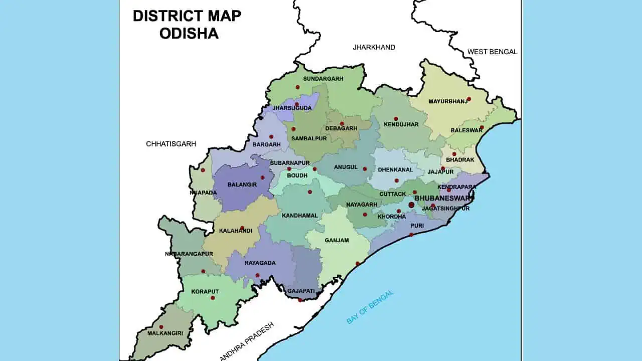 Odisha Map
Odisha is crisscrossed by rivers like the Mahanadi, Brahmani, and Baitarani, great for water sports and fishing. The state’s road and rail networks are well-developed. The Odisha map shows major and state highways, plus rail lines, aiding in travel planning.
Air travelers can find airport details on the map, including Biju Patnaik International Airport in Bhubaneswar and Jharsuguda Airport. The map also details Odisha’s parliamentary and assembly constituencies, interesting for those keen on its political scene.
The tourist map of Odisha is a comprehensive guide to the state’s major attractions, including its famous beaches, temples, wildlife sanctuaries, and national parks. The Odisha map will help you plan your itinerary and explore the best of what Odisha has to offer.
Consider reading – 20 Must Visit Best Tourist Places in Odisha
Exploring the 30 Districts on the Odisha Map
Odisha is a mosaic of 30 districts, each with a distinct soul. When you look at the Odisha map, you’ll see the coastal belt shimmering with potential, the central heartland pulsing with industry, and the western highlands whispering ancient tribal secrets. I’ve spent years traveling through these regions, and trust me, every district has a story that a simple dot on a map can’t fully capture.
Consider reading: Districts of Odisha
The Spiritual and Cultural Core: Bhubaneswar, Cuttack, and Puri
Bhubaneswar, our “Temple City,” is where my journey often begins. On the map, it’s a major node where the NH-16 meets the state’s administrative heart. But on the ground, it’s a place where you can smell the incense from the 10th-century Lingaraj Temple while sipping a coffee at a modern café. In 2026, the city has expanded, but its core remains timeless. For a local tip, don’t just stick to the main map; explore the old town lanes—they’re a labyrinth of history and small, forgotten shrines.
If you’re visiting the capital, you’ll want to check out the 11 best tourist places to visit in Bhubaneswar to make the most of your trip.
Cuttack, the “Silver City,” sits just a short hop away, nestled at the fork of the Mahanadi and Kathajodi rivers. Looking at the map, you can see how Cuttack’s island-like geography shaped its 1,000-year history. I always love visiting during Bali Jatra—the sheer scale of the fair along the riverbank is something you have to see to believe. The silver filigree work here, known as Tarakasi, is some of the finest in the world.
Puri is the crown jewel of the coastal map. Known globally for the Jagannath Temple, it’s a place of deep spiritual gravity. In 2026, the map of Puri has evolved significantly with the Heritage Corridor project, making the area around the temple much more accessible and beautiful. There’s a certain peace in watching the sunrise at the Blue Flag beach—the first in Asia—that no travel guide can quite put into words.
The Industrial and Natural Heartland: Angul and Sambalpur
Moving inland on the map, you hit Angul. Often seen as an industrial powerhouse with its coal mines and power plants, Angul District also hides some of Odisha’s best-kept secrets. The Satkosia Gorge, where the Mahanadi cuts through the Eastern Ghats, is a breathtaking sight. It’s a fascinating contrast—massive power plants on one side and the wild, untamed river flowing through deep canyons on the other.
Sambalpur is the gateway to Western Odisha. On the map, it’s defined by the massive Hirakud Dam, one of the longest in the world. But ask any local, and they’ll tell you about the intricate weave of a Sambalpuri Saree or the divine aura of the Samaleswari Temple. The rhythm of the Sambalpuri folk dance, the Dalkhai, is the heartbeat of this region, especially during the Nuakhai festival.
The Hidden Treasures: From Balangir to Koraput
Other districts on the map offer equally compelling reasons to visit:
- Balangir: Famous for the Harishankar Temple and the twin temples of Ranipur Jharial.
- Koraput: This is where the map starts to get hilly and green. Home to Deomali, the highest peak in the state, it’s a paradise for hikers and culture enthusiasts. The tribal markets here are a window into a way of life that has remained unchanged for centuries.
- Mayurbhanj: Look to the North-East on your map for the vast Similipal National Park. It’s a UNESCO Biosphere Reserve where you might just spot a melanistic tiger—a sight found nowhere else on Earth.
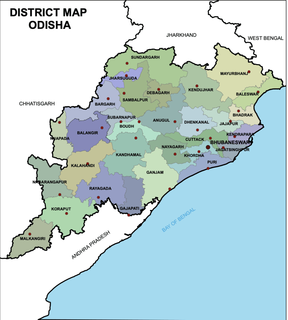 Odisha Map
The map also includes Bargarh, Boudh, Deogarh, Gajapati, Ganjam, Jagatsinghpur, Jajpur, Kalahandi, Kandhamal, Kendrapara, Khordha, Malkangiri, Nabarangpur, Nayagarh, Nuapada, Rayagada, and Subarnapur. Each of these districts is a world of its own, waiting to be explored.
Geographical and Demographic Profile of Odisha
When you look at a geographical map of Odisha, you’ll notice it’s predominantly hilly, with the Eastern Ghats acting as the state’s backbone. Covering 155,707 square kilometers, Odisha is India’s ninth-largest state, and its landscape is as diverse as its people.
The Landscape: Hills, Coasts, and Canyons
The Eastern Ghats run through the state, reaching their highest point at Deomali Hill in Koraput. If you’re a nature lover, the map of Odisha is a playground. The coastal region is a fertile plain, home to the sprawling Chilika Lake—the largest brackish water lagoon in Asia.
The state has a tropical climate. Our summers (April to June) can be intense, with temperatures ranging from 30°C to 45°C. But the monsoon, starting in June, turns the entire map into a lush, vibrant green. The winters, from October to February, are simply beautiful, with cool breezes and clear skies—the perfect time for a road trip.
The People: A Tapestry of Culture and Resilience
As of 2026, Odisha’s population has grown beyond the 41.9 million recorded in the 2011 census. While Hinduism is the primary religion (about 90%), the state is a melting pot of cultures, including significant Muslim, Christian, and Buddhist communities.
The official language is Odia, a language with a classical status and a rich literary history. You’ll also hear Hindi and English widely spoken in urban areas. What I find most inspiring about Odisha is the resilience of its people. Whether it’s facing cyclones or building world-class infrastructure, there’s a spirit of “Jai Jagannath” that unites everyone.
Agriculture remains the backbone of our economy, but the 2026 map shows a state rapidly industrializing. We’re not just the “Soul of Incredible India” because of our past; we’re a state building a bright future with new ports, tech hubs, and a booming tourism sector.
Navigating the Road Network on the Odisha Map
Odisha’s road network has seen a massive upgrade. As of 2026, we’re no longer just talking about connectivity; we’re talking about high-speed corridors that make a weekend trip from Bhubaneswar to the far reaches of the state a breeze. The state boasts over 78,000 kilometers of roads, and the map is now highlighted with several “Greenfield” projects.
Major High-Speed Corridors
The Bhubaneswar-Puri 8-lane Highway is a game-changer for pilgrims and tourists. I remember when this used to be a two-lane struggle; now, it’s a smooth 45-minute drive. Another critical artery on the 2026 map is the Capital Region Ring Road, which helps bypass the heavy traffic of Bhubaneswar and Cuttack, connecting the industrial hubs of Khordha and Choudwar.
Key National Highways include:
- NH-16 (formerly NH-5): The lifeline of the coast, connecting Chennai to Kolkata.
- NH-326: A vital link through the southern tribal belt, recently widened to improve access to Malkangiri.
- Bhubaneswar-Paradip High Speed Corridor: A brand new addition to the map that facilitates rapid freight and passenger movement.
The provided Odisha Map illustrates this extensive road network, connecting major towns and cities.
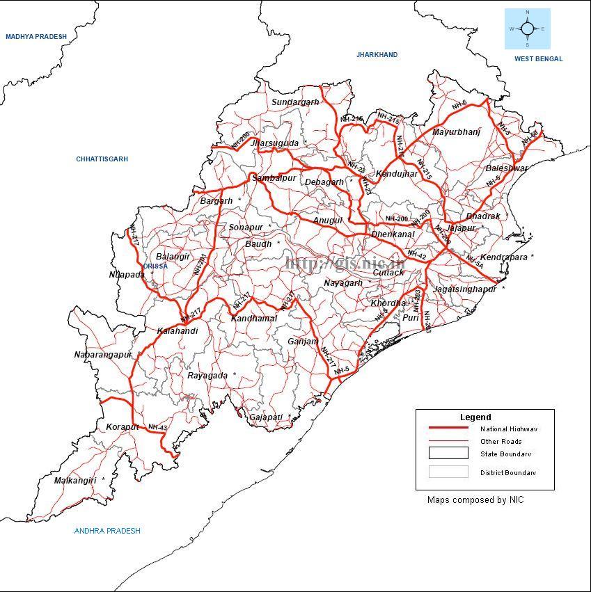 Road network map Odisha
For real-time road conditions and official updates, you can visit the Odisha Works Department website.
Riding the Rails: The 2026 Train Network
If you ask me, there’s no better way to see Odisha’s landscape than from the window of a train. The train network on the Odisha map has expanded into regions that were once considered unreachable. The East Coast Railway (ECoR), headquartered in Bhubaneswar, is now one of the most efficient zones in India.
New Lines and Modern Stations
The most exciting update on the 2026 rail map is the Puri-Konark New Rail Line. This 32-kilometer stretch finally connects the two wheels of spiritual Odisha—the Jagannath Temple and the Sun Temple. No more bumpy bus rides; you can now take a heritage shuttle between these two iconic sites.
Other major rail developments include:
- Amrit Bharat Stations: Over 50 stations, including Bhubaneswar, Cuttack, and Sambalpur, have been redeveloped into world-class travel hubs with airport-like amenities.
- Khurda Road-Balangir Line: A project that’s been in the works for decades is finally nearing full completion, bridging the gap between coastal and western Odisha.
- Vande Bharat Express: We now have multiple Vande Bharat routes connecting Bhubaneswar to Rourkela, Visakhapatnam, and Howrah.
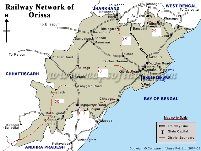 Rail Network Map Odisha
You can check the latest schedules and book tickets via the official IRCTC website.
The Lifeblood of the Land: Major Rivers on the Map
The rivers of Odisha aren’t just blue lines on a map; they are the soul of our civilization. When you see the massive delta formed by the Mahanadi, you’re looking at the reason why Odisha has been a land of prosperity for centuries.
The Mighty Mahanadi
The Mahanadi is our “Great River.” Originating in Chhattisgarh, it flows for 860 kilometers before emptying into the Bay of Bengal. On the map, it defines the geography of Sambalpur, Angul, and Cuttack. I highly recommend visiting the Hirakud Dam near Sambalpur—standing on the edge and looking at the vast expanse of water is a humbling experience.
The Sacred Brahmani and Baitarani
The Brahmani is formed by the confluence of the Sankh and South Koel rivers at Ved Vyasa near Rourkela. It’s a site steeped in mythology, believed to be the birthplace of Sage Vyasa. The Baitarani, another sacred river, marks the boundary of the ancient Kalinga empire.
Other notable rivers include:
- Rushikulya: Famous for the mass nesting of Olive Ridley sea turtles at its mouth.
- Subarnarekha: The “Golden River,” which flows through the northern part of the state near Baleswar.
 Odisha Rivers Map
For hydrological data and river management, the Department of Water Resources, Odisha is the official source.
Gateways to the Sky: Major Airports in 2026
The 2026 Odisha map shows a state that’s truly taking flight. Gone are the days when Bhubaneswar was the only entry point. We now have a decentralized aviation network that brings the world to every corner of Odisha.
Shree Jagannath International Airport, Puri
The biggest news in 2026 is the full operation of the Shree Jagannath International Airport in Puri. This world-class facility allows international pilgrims to land directly in the holy city, bypassing the 60-kilometer drive from Bhubaneswar. It’s a stunning piece of architecture that incorporates Odia motifs and stone carvings.
Reaching the Hinterlands
- Biju Patnaik International Airport (BBI): Still the primary hub, but now with a massive Terminal 3 to handle increased international traffic.
- Veer Surendra Sai Airport, Jharsuguda: The gateway to Western Odisha’s industrial and mining heartland.
- Malkangiri and Jeypore Airports: These new additions on the map have revolutionized travel to South Odisha, turning what was once a 15-hour road journey into a 60-minute flight.
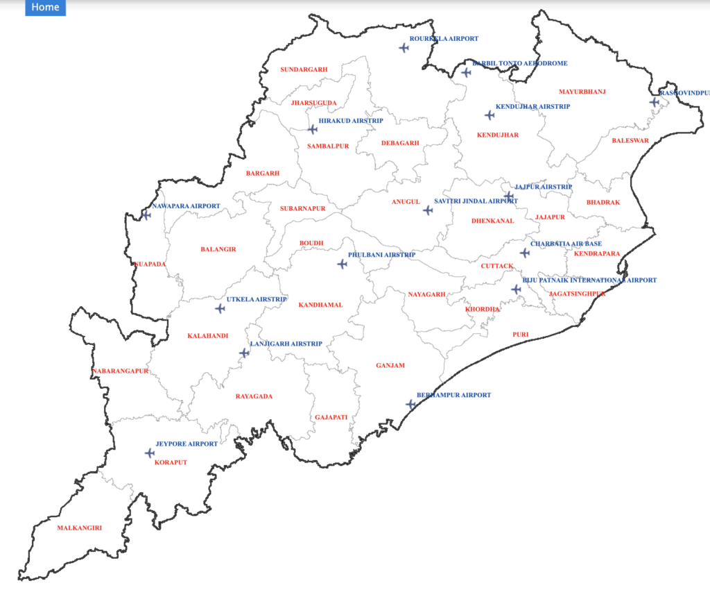 Odisha Airports map
For flight information and official updates, check the Airports Authority of India (AAI) website.
Crafting Your Journey: The Odisha Tourist Map 2026
If you’re like me, you probably love the feeling of tracing a route on a map before you even set foot out the door. The Odisha tourist map is more than just a list of locations; it’s a menu of experiences. In 2026, the map has been reorganized to highlight specific “circuits” that make travel more logical and rewarding.
The Golden Triangle: Spiritual and Architectural Splendor
The most famous circuit on any Odisha map is the Golden Triangle, connecting Bhubaneswar, Puri, and Konark. This route is the heart of Odia culture.
- Bhubaneswar: Start with the Lingaraj Temple and the Udayagiri and Khandagiri Caves.
- Puri: Head south to witness the grandeur of the Jagannath Temple.
- Konark: Don’t miss the UNESCO World Heritage Sun Temple.
The Buddhist Diamond Triangle
To the North-East of Bhubaneswar, you’ll find the Diamond Triangle—Ratnagiri, Lalitgiri, and Udayagiri. These sites are home to ancient Buddhist monasteries and stupas that once hosted scholars from across the globe.
The Wildlife and Nature Circuit
If you’re a nature lover, your map should be marked with:
- Similipal National Park: In Mayurbhanj, for tigers and elephants.
- Bhitarkanika: In Kendrapara, for the world’s largest saltwater crocodiles and stunning mangroves.
- Chilika Lake: The pride of the Ganjam and Khordha districts, perfect for birdwatching and dolphin spotting.
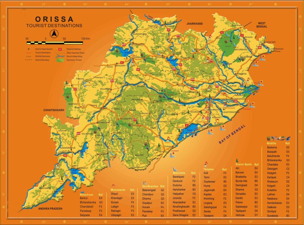 Odisha Tourist Map
For more inspiration, explore the 20 must-visit best tourist places in Odisha to find your next adventure.
Planning Your Itinerary Using the 2026 Odisha Map
Based on my years of exploring the state, here are three ways to use the map to plan your 2026 trip:
- The Coastal Explorer (7 Days): Bhubaneswar (2 days) → Puri (2 days) → Konark (1 day) → Chilika/Gopalpur (2 days). This uses the high-speed NH-16 and the new Puri rail line.
- The Tribal Heart (10 Days): Fly into Jeypore → Koraput (3 days) → Malkangiri (2 days) → Rayagada (2 days) → Balangir (3 days). This is now possible thanks to the Malkangiri airport and improved southern road networks.
- The Heritage & Nature Trail (8 Days): Bhubaneswar (2 days) → Diamond Triangle (2 days) → Bhitarkanika (2 days) → Similipal (2 days). This covers the rich history and ecology of North Odisha.
Odisha Map: From Blocks to Urban Centers
When you zoom in on the Odisha map, you start to see the 314 blocks that form the backbone of the state’s administration. Each block is a unique administrative unit, often centered around a major town or village.
In 2026, these blocks have become more than just lines on an administrative map. They are centers of local governance and the starting points for rural tourism. For instance, the blocks in the Ganjam district are known for their vibrant folk arts, while the blocks in Mayurbhanj are centers of traditional Dokra craft.
Urban Centers and Smart Cities
Our map also highlights the “Smart Cities” like Bhubaneswar and Rourkela, which have undergone a digital and infrastructure revolution. These urban centers serve as the perfect base for exploring the surrounding rural blocks.
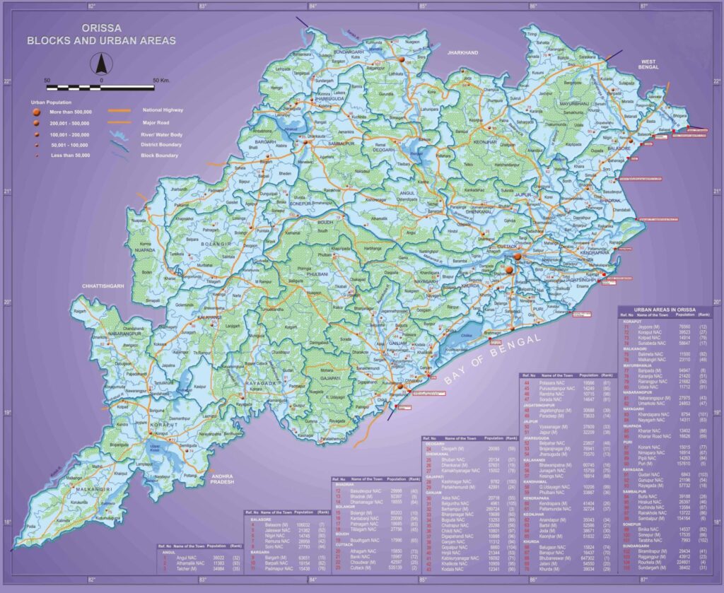 Odisha map covering blocks and Urban areas
The Political Geography: Parliament and Assembly Maps
When we talk about the Odisha map, we can’t ignore its political heartbeat. Odisha is divided into 21 Parliamentary constituencies and 147 Assembly constituencies. For those of us living here, these lines represent our voice in the democracy of India.
Understanding the 21 Parliamentary Constituencies
On the map, the 21 Parliamentary seats are distributed to ensure that even the most remote parts of the state have representation in the Lok Sabha. For example, the Koraput constituency covers a vast area of the southern highlands, while the Bhubaneswar and Cuttack seats are more compact but represent a massive urban population.
Key constituencies on the map include:
- Puri: A seat of high spiritual and political importance.
- Sambalpur: Representing the voice of Western Odisha.
- Mayurbhanj: A key seat for the tribal communities of the North-East.
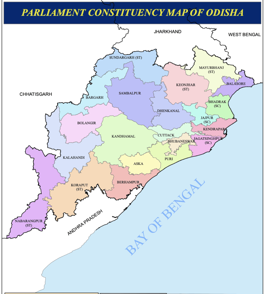 Parliament Constituency Map Of Odisha
The 147 Assembly Constituencies: Local Governance
The 147 Assembly seats on the map are where local issues come to the forefront. These constituencies are the building blocks of the Odisha Legislative Assembly in Bhubaneswar. Every time an election comes around, the political map of Odisha becomes the most-watched document in the state, with analysts tracing every shift in the “mood of the people.”
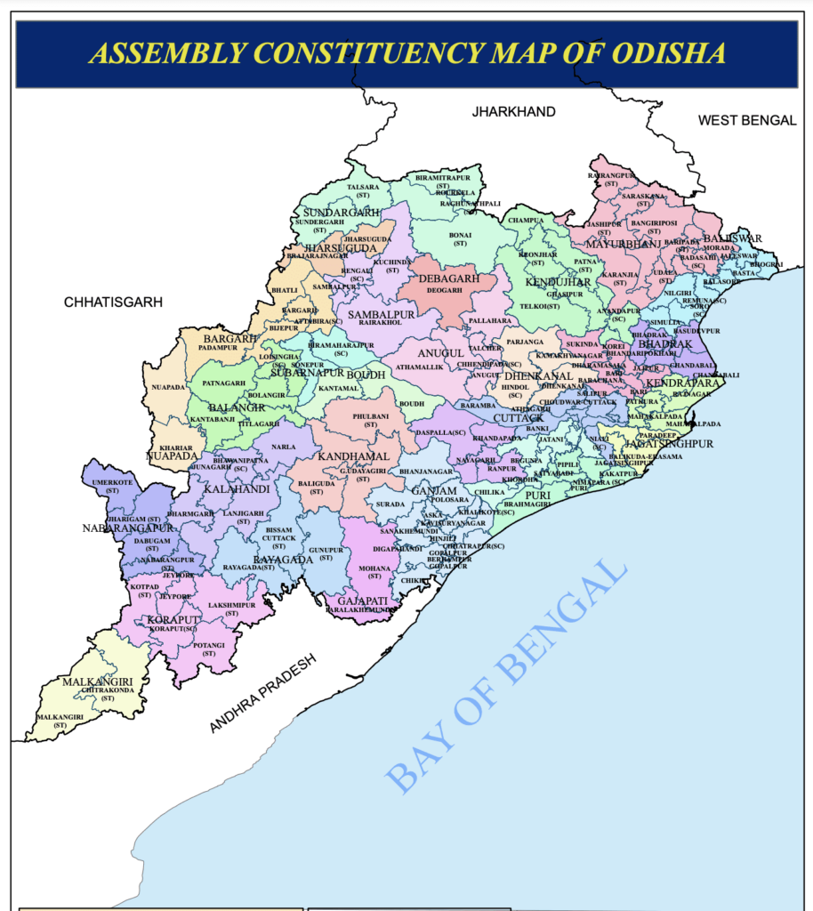 Assembly constituency map of Odisha
For official electoral maps and details, the Chief Electoral Officer, Odisha website is the authoritative source.
A Journey Through Time: The 1936 Odisha Map
Looking at a modern map of Odisha is one thing, but looking at the 1936 Odisha Map is like looking at the birth certificate of our state. On April 1, 1936, Odisha became the first state in India to be formed on a linguistic basis. This was the result of decades of struggle by legends like Madhusudan Das, Gopabandhu Das, and Maharaja Krushna Chandra Gajapati.
The Original Six Districts
If you look at the 1936 map below, you’ll notice that Odisha only had 6 districts back then. It’s fascinating to see how the borders have evolved:
- Koraput: A massive district that covered much of what is now South Odisha.
- Ganjam: The southern gateway.
- Puri: The spiritual heart.
- Cuttack: The historical capital.
- Balasore: The northern coastal hub.
- Angul (then written as Anugul): The gateway to the central forests.
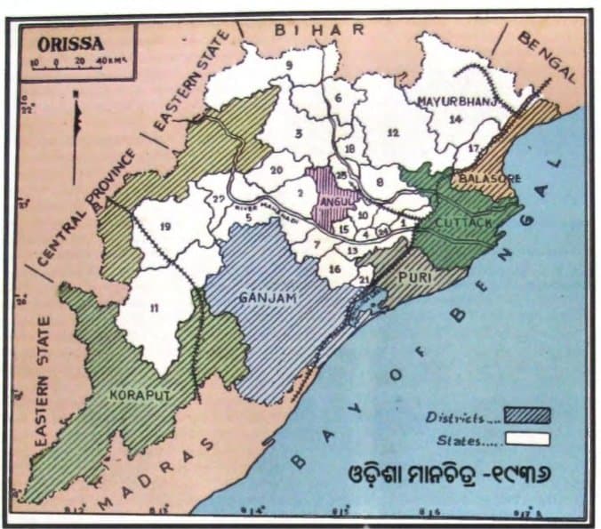 1936 Odisha Map
The journey from these 6 districts to the 30 districts we see on the map today tells the story of Odisha’s administrative growth and its commitment to bringing governance closer to every citizen. I often find myself staring at this old map, thinking about the pioneers who dreamed of a unified land for Odia speakers. It’s a reminder that every line on our map was drawn with purpose and pride.
The Soul of the Land: A Cultural Map of Odisha
Beyond the roads and rivers, there’s a “Cultural Map” of Odisha that you won’t find in an atlas, but you’ll feel in every town. It’s a map of colors, rhythms, and flavors.
Mapping Art and Craft
- Raghurajpur (Puri): The heart of Pattachitra painting. Almost every house here is an art gallery.
- Pipli (Puri): Famous for its vibrant Appliqué work. You can see the colorful lanterns and umbrellas from miles away on the NH-16.
- Sonepur & Bargarh: The hub of the world-famous Sambalpuri handloom.
Mapping the Tastes of Odisha
If you’re a foodie, your map of Odisha should include:
- Cuttack for Dahi Bara Aloo Dum.
- Pahala (on the Bhubaneswar-Cuttack road) for the legendary Rasagola.
- Puri for the sacred Mahaprasad of Lord Jagannath.
- Baripada for Mudhi Mansa (puffed rice and mutton).
Expert Tips for Using the Odisha Map to Plan Your Trip
After years of traversing these roads, here are a few local secrets to help you navigate:
- Trust the Locals, Not Just GPS: While Google Maps is great, it can sometimes lead you down narrow “shortcut” forest roads in districts like Kandhamal. Always verify with locals if you’re heading into remote areas.
- The “Golden Hour” of Travel: Most of our state highways are beautiful at dawn. If you’re driving from Bhubaneswar to Puri or Konark, start early to catch the sunrise over the paddy fields—it’s a sight you’ll never forget.
- Language is the Best Map: Learning a few Odia phrases like “Eita kete dura?” (How far is this?) or “Namaskar” will open doors and hearts in any block you visit.
- Carry a Physical Map in the Ghats: In the deep valleys of Koraput or Rayagada, mobile signals can be patchy. Having a physical copy or an offline map of Odisha is a lifesaver.
Frequently Asked Questions (FAQs) on the Odisha Map
What is the best way to travel from Bhubaneswar to the new Puri International Airport in 2026?
The best way is via the newly expanded 8-lane Bhubaneswar-Puri Highway (NH-316). It’s a smooth 45-minute drive. You can also take the heritage rail shuttle if you’re coming from the Puri city center.
Which is the highest point on the Odisha map for trekking?
Deomali Hill in the Koraput district is the highest peak in Odisha, standing at 1,672 meters. It’s a popular spot for trekking and offers breathtaking views of the Eastern Ghats.
How can I find the best time to visit Chilika Lake on the map?
Chilika Lake is best visited between November and February when migratory birds from Siberia and the Caspian Sea arrive. On the map, you should focus on the Mangalajodi and Nalabana Bird Sanctuary areas.
What are the major rivers shown on the Odisha map for water sports?
The Mahanadi (near Cuttack and Sambalpur) and the Brahmani (near Rourkela) are the major rivers for water sports. Tampara Lake in Ganjam is another excellent spot for kayaking and boating.
How many airports are currently operational in Odisha as of 2026?
As of 2026, Odisha has several operational airports, including Biju Patnaik International Airport (Bhubaneswar), Shree Jagannath International Airport (Puri), Veer Surendra Sai Airport (Jharsuguda), Utkela (Bhawanipatna), Jeypore, and Malkangiri.
Where can I find a map of the Buddhist Diamond Triangle in Odisha?
The Diamond Triangle, consisting of Ratnagiri, Lalitgiri, and Udayagiri, is located in the Jajpur and Cuttack districts. Most tourist maps of Odisha clearly mark these sites as they are just a 2-hour drive from Bhubaneswar.
What is the historical significance of the 1936 Odisha Map?
The 1936 map represents the formation of Odisha as the first linguistic state in India on April 1, 1936. It originally had only six districts: Cuttack, Puri, Baleswar, Ganjam, Koraput, and Sambalpur (with Angul being part of the administrative setup).
Final Thoughts: More Than Just Lines and Dots
As I fold my map of Odisha at the end of another journey, I’m reminded that these lines are more than just boundaries—they are the threads of a vibrant tapestry. Whether you’re following the flow of the Mahanadi or tracing the new high-speed rail lines, you’re engaging with a land that is as resilient as it is beautiful.
The 2026 Odisha Map is a testament to our growth, but the spirit of the land remains rooted in our ancient temples, our sacred rivers, and the warm smiles of our people. So, don’t just look at the map—get out there and experience the soul of Incredible Odisha. Jai Jagannath!