Angul District Guide 2026: Map, Blocks, Places & History
Comprehensive guide to Angul district in Odisha. Explore 8 administrative blocks, subdivisions, Satkosia Gorge, Saila Srikhetra, industries, and travel routes.
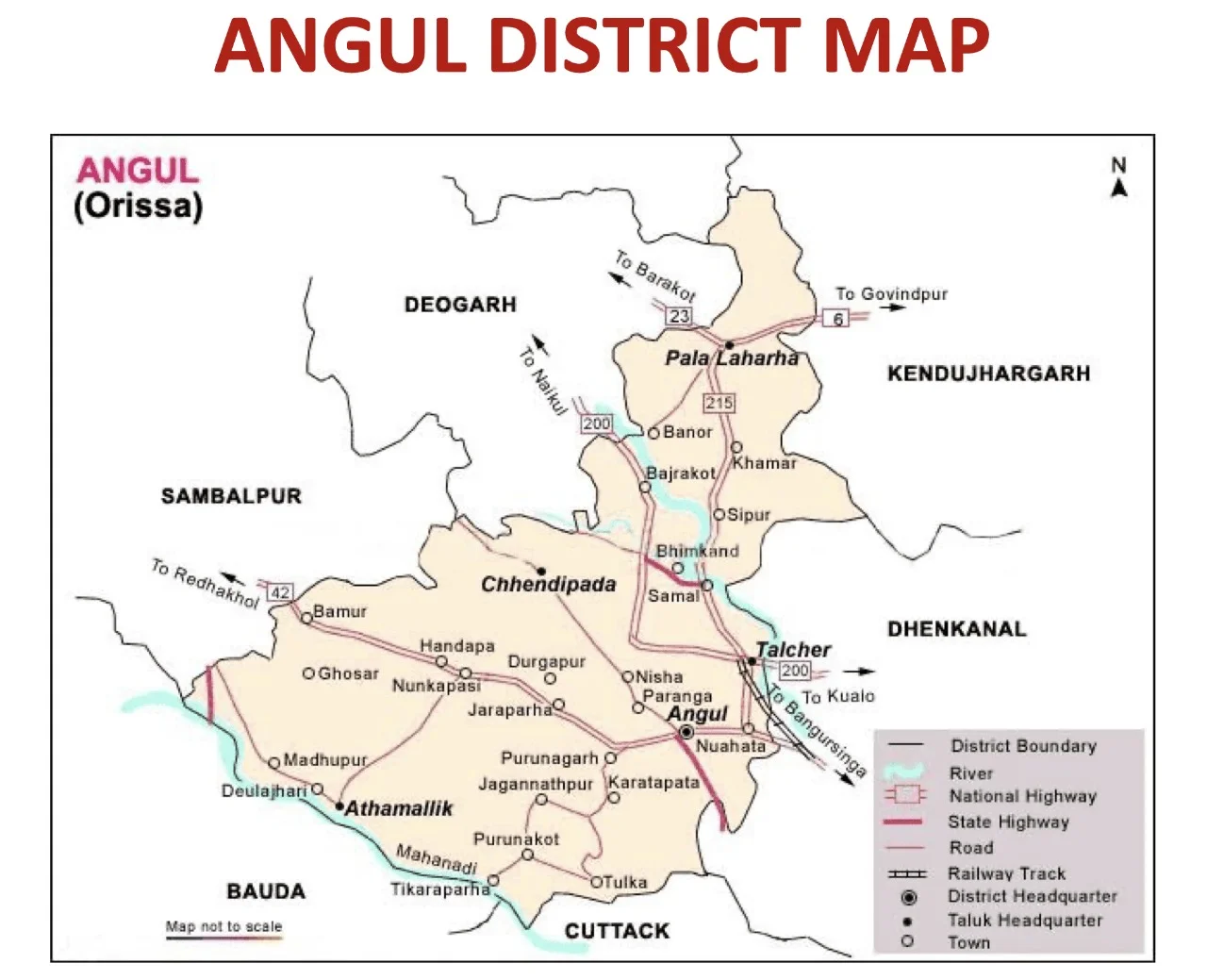
Angul district forms the central geographic heartland of Odisha, connecting the coastal plains of Cuttack to the western highlands of Sambalpur. It spans 6,375 square kilometers of rolling river basins, sal forests, and mineral-rich hills across central Odisha.
Formed as an independent district on April 1, 1993, following the reorganisation of undivided Dhenkanal, Angul represents a convergence of heavy industry and wildlife biodiversity. The territory hosts the colossal coal seams of Talcher alongside the deep waters of the Mahanadi River slicing through the Eastern Ghats.
Few regions in eastern India balance large-scale industry and untamed nature quite like Angul. Within an hour’s drive, heavy machinery operates along active coal pits near Talcher while river terns and mugger crocodiles rest peacefully along the secluded sandbars of Satkosia Gorge.
Key Takeaways
- Angul district is divided into 4 subdivisions (Angul, Athmallik, Talcher, and Pallahara) and exactly 8 community development blocks.
- The district spans 6,375 square kilometers across central Odisha, bordered by Dhenkanal, Cuttack, Nayagarh, Boudh, Subarnapur, Sambalpur, Deogarh, and Kendujhar.
- Major natural attractions include Satkosia Gorge Tiger Reserve, Tikarpada gharial research center, Bhimkund rock-cut Vishnu sculpture, and Rengali Dam.
- Angul serves as the industrial energy capital of Odisha, hosting Mahanadi Coalfields Limited (MCL), NALCO aluminium smelter, NTPC Kaniha, and Jindal Steel and Power.
- The ideal travel window spans October through March, offering cool daytime temperatures suitable for wildlife safaris and temple tours.
At-a-Glance: Angul District Demographic and Geographic Profile
Angul district occupies the transition zone between the coastal deltaic system and the Garhjat hills of northwestern Odisha. The landscape is defined by two major perennial rivers: the Mahanadi flowing along its southern flank and the Brahmani coursing through its northern and eastern valleys. Forest canopy covers more than 43 percent of the district, creating continuous wildlife corridors between central Indian forests and the Similipal biosphere.
According to the official 2011 Census of India, Angul registered a total population of 1,273,821 residents across 1,911 revenue villages. The district maintains a healthy literacy rate of 77.53 percent, which places it significantly above the national rural average. Urban centers cluster around Angul municipality and Talcher coal mining complexes, while rural settlements dominate Athmallik and Pallahara.
For wider spatial orientation across state borders, consult the comprehensive Odisha district map and rail routes to observe how Angul connects with adjoining territorial divisions.
| Demographic and Geographic Indicator | Statistical Figure and Official Detail |
|---|---|
| District Area | 6,375 square kilometers (ranks 11th in Odisha) |
| District Headquarters | Angul Town (Civic and Administrative Collectorate) |
| Total Population (Census 2011) | 1,273,821 residents |
| Male Population | 655,718 |
| Female Population | 618,103 |
| Sex Ratio | 943 females per 1,000 males |
| Population Density | 200 persons per square kilometer |
| Overall Literacy Rate | 77.53 percent |
| Male Literacy Rate | 85.98 percent |
| Female Literacy Rate | 68.64 percent |
| Administrative Subdivisions | 4 (Angul, Athmallik, Talcher, Pallahara) |
| Community Development Blocks | 8 administrative blocks |
| Revenue Tehsils | 8 tehsils |
| Gram Panchayats | 225 Gram Panchayats |
| Inhabited Revenue Villages | 1,911 villages |
| Regional Transport Office (RTO) Code | OD-19 (Angul) |
| Primary River Systems | Mahanadi, Brahmani, Tikira, Samakoi, Singdajhor |
| Bordering Districts | Dhenkanal (east), Cuttack & Nayagarh (south), Boudh & Subarnapur (west), Sambalpur & Deogarh (northwest), Kendujhar (north) |
Landmark Directory: Key Attractions Located in Angul District
Travelers and researchers often need to confirm whether specific regional landmarks fall within Angul or neighbouring districts like Dhenkanal and Cuttack. The table below clarifies the exact administrative blocks, distances from Angul town, and key features for each destination.
| Landmark Name | Classification | Exact Block / Location | Distance from Angul Town | Notable Strategic Feature |
|---|---|---|---|---|
| Satkosia Gorge Sanctuary | Wildlife & River Canyon | Angul / Athmallik borders | 60 km south | 22 km river canyon carved by Mahanadi with Gharial conservation |
| Tikarpada Eco-Camp | Eco-Tourism Hub | Angul Block (Mahanadi Riverbank) | 58 km south | Sandbar tented camping, crocodile breeding center, and river rafting |
| Saila Srikhetra | Spiritual Shrine | Angul Town (Sunasagad Hill) | 2 km from railway station | Hilltop Jagannath temple with grand stone carvings and annual Rath Yatra |
| Bhimkund Rock-Cut Vishnu | Ancient Monolithic Site | Kaniha Block (Brahmani Riverbank) | 82 km north | 42-foot reclining Ananta Sayana Vishnu carved in 8th-century stone |
| Rengali Dam & Reservoir | Multipurpose Hydel Dam | Rengali (Pallahara / Talcher) | 85 km north | 70-meter masonry dam on Brahmani River with winter migratory birding |
| Deulajhari Hot Springs | Geothermal & Pilgrimage | Athmallik Block | 90 km west | Natural sulfur hot springs with healing properties and ancient Shiva shrines |
| Maa Hingula Temple | Shakti Pitha Shrine | Gopalprasad (Talcher Block) | 28 km northeast | Sacred natural subterranean flame worship with annual Hingula Yatra |
| Binikei Peetha | Riverside Scenic Shrine | Athmallik Block (Mahanadi Riverbank) | 88 km west | Riverbank temple situated amidst rocky gorges and dense sal woodland |
| Malayagiri Mountain Peak | Trekking & Hill Peak | Pallahara Block | 105 km north | Highest elevation in Angul (1,187 meters) with seasonal natural waterfalls |
| Talcher Palace (Rajbati) | Royal Maratha-Era Estate | Talcher Town | 24 km northeast | Historic seat of the Talcher royal dynasty overlooking Brahmani River |
Administrative Setup: How Many Blocks and Subdivisions in Angul District?
Angul operates under a four-tier revenue administrative structure structured to deliver governance across diverse industrial valleys and rural forest belts. The district collectorate sits at Angul town, coordinating civic governance, disaster response, and industrial welfare. The territory is officially split into 4 revenue subdivisions: Angul Sadar, Athmallik, Talcher, and Pallahara.
Each subdivision is headed by a Sub-Collector who oversees land administration, law enforcement, and developmental schemes. Below the subdivisional level, the district functions through 8 Community Development (CD) blocks and 8 corresponding revenue tehsils. These blocks supervise 225 Gram Panchayats, managing public distribution systems, rural road networks, and rural employment programs across central Odisha.
The northern subdivisions of Talcher and Pallahara manage mineral extraction leases and tribal welfare administration. Meanwhile, Athmallik subdivision administers the heavily forested western frontier along the Mahanadi corridor, where community-based forest protection committees partner with the state forest department.
Complete Directory of the 8 Administrative Blocks in Angul
The 8 administrative blocks of Angul district reflect diverse local livelihoods, ranging from opencast coal mining in Talcher to rural agro-forestry in Kishorenagar. Each block operates its own panchayat network, block development office, and community infrastructure.
| Community Block | Revenue Subdivision | Block Headquarters | Gram Panchayats | Inhabited Villages | Dominant Economic and Geographic Focus |
|---|---|---|---|---|---|
| Angul | Angul Sadar | Angul Town | 32 | 212 | Civic governance, commerce, engineering services, and gateway to Satkosia |
| Athmallik | Athmallik | Athmallik NAC | 25 | 246 | Forest produce gathering, paddy farming, river fishery, and religious pilgrimage |
| Banarpal | Angul Sadar | Banarpal | 27 | 138 | Large-scale aluminium smelting (NALCO), ancillary fabrication, and NH-55 transit |
| Chhendipada | Angul Sadar | Chhendipada | 36 | 134 | Coal exploration reserves, medium-scale agriculture, and traditional brassware |
| Kaniha | Talcher | Kaniha | 27 | 192 | Super thermal power generation (NTPC), Brahmani river farming, and Bhimkund |
| Kishorenagar | Athmallik | Kishorenagar | 23 | 218 | Rainfed agriculture, pulse production, timber harvesting, and minor forest produce |
| Pallahara | Pallahara | Pallahara NAC | 27 | 268 | Upland farming, iron-ore border transit, Malayagiri ecotourism, and forestry |
| Talcher | Talcher | Talcher Town | 28 | 153 | Opencast coal mining (MCL), heavy machinery logistics, and thermal power |
Rural development schemes across these blocks are implemented through the District Rural Development Agency (DRDA). Water harvesting structures, check dams along mountain streams, and self-help group federations provide primary livelihood support in non-mining agrarian blocks like Kishorenagar and Athmallik.
Vidhan Sabha and Parliamentary Constituencies in Angul
Angul district encompasses 5 Legislative Assembly (Vidhan Sabha) constituencies, each represented in the Odisha Legislative Assembly. The territorial delimitation aligns local geographic boundaries with demographic concentrations, balancing industrial belts and agricultural constituencies.
Under the parliamentary framework governed by the Election Commission of India Delimitation Directory, Angul district is divided between two separate Lok Sabha parliamentary seats. This dual-constituency arrangement links northern Angul to the coal-power belt of Dhenkanal, while connecting western blocks to the Sambalpur upland valley.
| Constituency Number & Name | Category | Administrative Blocks Included | Corresponding Lok Sabha (Parliamentary) Seat |
|---|---|---|---|
| AC 59: Pallahara | General | Pallahara block and surrounding forest belt | PC 09: Dhenkanal Parliamentary Constituency |
| AC 60: Talcher | General | Talcher block, Talcher municipality, and mining areas | PC 09: Dhenkanal Parliamentary Constituency |
| AC 61: Angul | General | Angul municipality, Angul block, and Banarpal part | PC 09: Dhenkanal Parliamentary Constituency |
| AC 62: Chhendipada | Scheduled Caste (SC) | Chhendipada block and adjoining rural sectors | PC 03: Sambalpur Parliamentary Constituency |
| AC 63: Athmallik | General | Athmallik NAC, Athmallik block, and Kishorenagar block | PC 03: Sambalpur Parliamentary Constituency |
This parliamentary division ensures that Athmallik and Chhendipada maintain strong representation tied to the western Odisha development corridor. Meanwhile, Angul, Talcher, and Pallahara collaborate closely with Dhenkanal on industrial infrastructure planning, rail line expansions, and highway maintenance.
Historical Heritage, Princely Feudatories, and Prajamandal Struggles
The documented history of Angul spans more than a millennium, rooted in ancient kingdoms that flourished along the Brahmani and Mahanadi river valleys. Early stone inscriptions reveal that the region formed part of the Kodālaka Mandala during the 8th and 9th centuries under the Shulki rulers. Subsequent administrative control shifted through the Bhauma-Kara sovereigns, Somavamshi monarchs, and the Imperial Gangas, who erected stone temples and monolithic rock shrines.
Prior to British intervention, the territory comprised separate princely feudatories known as Garhjats, notably Talcher, Pallahara, and Athmallik. Angul itself was a feudatory state governed by the Rajas of Angul until 1847.
In 1847, Raja Somnath Singh Jagadev rebelled against British colonial authority by defying revenue demands and aiding tribal insurgents in neighboring Boudh. The British East India Company confiscated Angul, exiling the ruler and placing the territory under direct colonial administration as an Exempted District under Regulation I of 1874.
The Prajamandal movement gained intense momentum across the Angul and Talcher region during the late 1930s. Oppressed peasants and mine laborers revolted against the autocratic feudal rule and exorbitant taxes imposed by the princely rulers of Talcher and Dhenkanal. Thousands of satyagrahis launched non-violent protests, facing police firings and exile.
Following India’s independence in 1947, the princely states of Talcher, Pallahara, and Athmallik merged with the Indian Union in January 1948. These regions were initially amalgamated into undivided Dhenkanal district for administrative convenience. Recognizing the rapid economic expansion of the mining belt, the Government of Odisha reorganized the territory on April 1, 1993, creating modern Angul as a separate district.
Notable Personalities and Freedom Fighters of Angul
Angul has nurtured outstanding statesmen, social reformers, and grassroots freedom fighters who made foundational contributions to Odisha’s modern history. Their legacy continues to shape the cultural and educational landscape of central Odisha.
Nabakrushna Choudhury, one of Odisha’s most respected Chief Ministers, made Angul his operational base for social reconstruction. A steadfast Gandhian and freedom fighter, he spearheaded land reforms and promoted decentralized rural governance across the state. Along with his wife Malati Choudhury, he established the Bajirout Chhatravas at Angul in 1946, an egalitarian residential school dedicated to educating children of freedom fighters and marginalized tribal communities.
Malati Choudhury, affectionately remembered as “Toophan” by Mahatma Gandhi for her relentless energy, was a fearless warrior in the Salt Satyagraha and Prajamandal struggles. She championed the rights of bonded laborers, forest-dwelling communities, and tribal youth throughout Angul and Athmallik. Her ashram at Baji Rout Chhatravas remains an active center of Gandhian social philosophy and women’s empowerment.
Pabitra Mohan Pradhan stood as the legendary supreme commander of the Talcher Prajamandal movement and the underground Mukti Bahini. Escaping royal custody multiple times, he mobilized tens of thousands of rural citizens against royal tyranny. Post-independence, Pradhan served as the Deputy Chief Minister of Odisha, authoring foundational historical accounts of the freedom struggle in the Garhjat hills.
Industrial Capital of Odisha: Thermal Power, Coalfields, and Metallurgy
Angul district functions as the industrial powerhouse of eastern India, generating substantial shares of Odisha’s commercial electricity and mined energy resources. The district owes its economic prominence to the Talcher Coalfield, discovered in the mid-19th century. Managed by Mahanadi Coalfields Limited (MCL), a subsidiary of Coal India Limited, Talcher holds estimated coal reserves exceeding 50 billion metric tons across extensive opencast quarries.
Thermal power production represents the district’s primary economic output. NTPC operates the Talcher Super Thermal Power Station at Kaniha with an installed capacity of 3,000 MW, transmitting electrical energy to several states across eastern and southern India. Additionally, NTPC oversees the historic Talcher Thermal Power Station (TTPS), which is undergoing substantial modernization into advanced supercritical generation units.
Metallurgical manufacturing forms the second pillar of Angul’s industrial ecosystem. The National Aluminium Company Limited (NALCO) operates a globally recognized aluminium smelter plant at Banarpal, producing high-purity ingots, wire rods, and billets. Supported by its 1,200 MW captive power plant, NALCO drives a thriving downstream ecosystem of aluminium fabrication units across the district.
Private steel production also maintains a major presence at Nisha, where Jindal Steel and Power Limited (JSPL) operates a massive integrated steel complex. As detailed by the Incredible India Official Odisha Tourism Portal, district administrators actively work to reconcile intense core industrial production with environmental safeguards and wildlife corridor protection.
Major Educational Institutions and Healthcare Infrastructure
Angul has developed a solid educational network that balances technical training, university degrees, and industrial apprenticeships. The presence of major public sector undertakings has fostered world-class schools alongside regional colleges.
Higher educational institutions include Angul Autonomous College, established in 1957, which provides undergraduate and postgraduate degree programs in arts, science, and commerce. It serves as the primary regional center for higher academic learning in the district.
Technical education is supported by state technical colleges like the Indira Gandhi Institute of Technology (IGIT) at Sarang, located just across the Brahmani River near Talcher. These engineering academies supply skilled talent to power stations and mining corporations across the industrial corridor.
Primary and secondary education benefits from established residential institutions, including Kendriya Vidyalayas at Angul, Talcher, and Kaniha, alongside private industrial schools managed by NALCO, NTPC, and JSPL. The historic Bajirout Chhatravas continues to offer value-based residential schooling for tribal and rural students from remote forest blocks.
Healthcare services are anchored by the District Headquarter Hospital (DHH) in Angul town, which provides multi-specialty inpatient care, emergency trauma units, and maternal welfare facilities. Specialized industrial hospitals operated by NALCO at Banarpal and NTPC at Kaniha deliver advanced medical attention for plant personnel and neighboring rural populations. Community Health Centers (CHCs) operate across all 8 block headquarters to provide primary healthcare delivery.
Iconic Gastronomy: What to Eat Across Angul District
The culinary identity of Angul reflects a delicious harmony of central Odia culinary traditions, riverine freshwater harvests, and rural forest ingredients. Fresh vegetables, mustard pastes, and seasonal forest produce form the everyday diet across local households.
Freshwater river fish from the Mahanadi and Brahmani river systems is highly celebrated across Angul and Athmallik. Local eateries prepare traditional Machha Besara, featuring fresh Rohu or Katla cooked in an aromatic ground mustard and dried mango (Ambula) gravy. In Athmallik and Kishorenagar, tribal communities gather wild mushrooms and bamboo shoots (Karadi) during the monsoon to create flavorful stir-fries and slow-cooked curries.
Visitors exploring authentic regional meals should review our guide to famous authentic foods of Odisha to discover traditional classics like Dalma, Pakhala Bhata, and Chenna Poda. In Angul town, local sweet stalls craft soft Chenna Jhili and fresh Chenna Gaja, offering an irresistible sweet treat after savoring a spicy Odia thali.
Street food culture centers around hot Bara Ghuguni and crispy Piaji served with zesty mint chutney outside Angul railway station and bus terminals. During the winter harvest, rural families prepare varieties of steamed Pitha, such as Enduri Pitha flavored with fragrant turmeric leaves and stuffed with sweet coconut jaggery.
Top Tourist Attractions and Wildlife Circuit in Angul
Angul offers an extraordinary travel circuit combining wild river canyons, wildlife sanctuaries, and monumental archaeological wonders. Whether tracking wild elephants or examining thousand-year-old rock carvings, travelers find captivating experiences throughout the district.
1. Satkosia Gorge Tiger Reserve and River Ecosystem
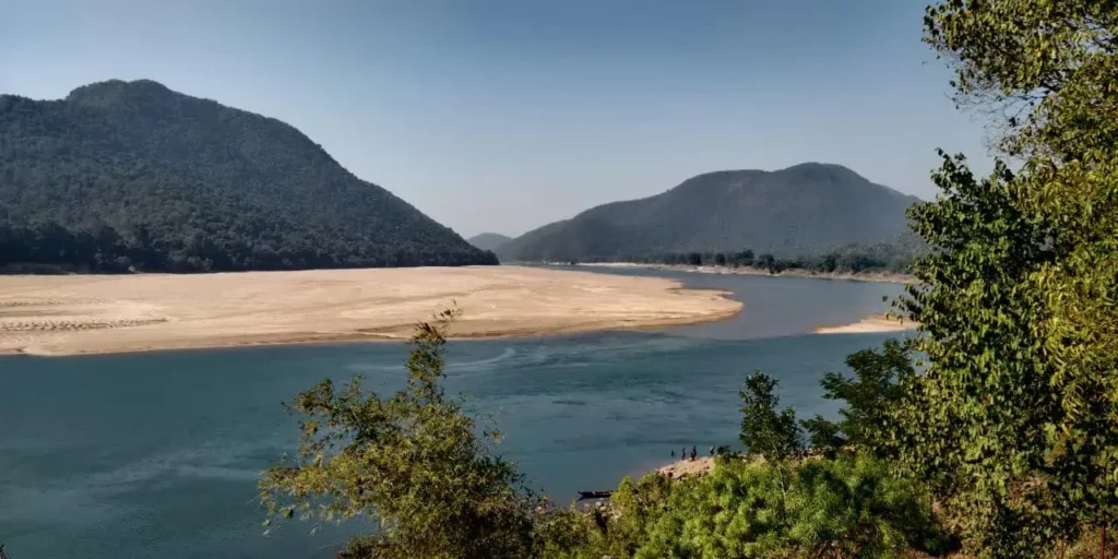
Satkosia represents one of the most stunning river gorge landscapes in peninsular India. The Mahanadi River cuts through the Eastern Ghats for 22 continuous kilometers, creating a deep canyon flanked by dense sal, teak, and bamboo forests. The reserve shelters Bengal tigers, leopards, wild dogs, Indian gaur, and large herds of Asian elephants.
Travelers can consult our detailed Satkosia Tiger Reserve and Gorge guide to plan riverboat cruises, tented campsite stays, and guided wildlife walking trails.
2. Tikarpada Wildlife Sanctuary and Gharial Research Center
Tikarpada sits directly on the banks of the Mahanadi, 58 km south of Angul town. It earned global renown in 1975 when the Government of Odisha established a specialized captive breeding and conservation research project for the critically endangered Gharial crocodile. Visitors can observe adult gharials basking on river sandbars and tour the research hatchery.
The riverside location also serves as the main base for regulated community boating excursions and seasonal whitewater river rafting through the gorge waters.
3. Bhimkund Monolithic Rock-Cut Vishnu Image
Situated near Kaniha on the right bank of the Brahmani River, Bhimkund is an astonishing 8th-century archaeological treasure. The site features a colossal open-air sculpture of Lord Vishnu reclining on the coils of Ananta Shesha, measuring an impressive 42 feet in length carved directly into the living river bedrock.
Maintained under the regulatory framework of the Archaeological Survey of India Protected Heritage Directory, this Bhauma-Kara masterpiece depicts the sleeping deity with composed facial contours and sacred emblems, mirroring similar rock-cut sculptures found at Sarang.
4. Rengali Dam and Multipurpose Reservoir
Located 85 km north of Angul town on the Brahmani River, Rengali Dam is an imposing masonry engineering structure standing 70 meters high. The vast reservoir inundates hundreds of square kilometers, forming an expansive aquatic landscape surrounded by forested hills.
During the winter months from November to February, the reservoir attracts thousands of migratory water birds, including whistling ducks, bar-headed geese, and painted storks, making it an exceptional destination for nature photographers.
Sacred Shrines and Spiritual Heritage of Angul
Angul district preserves deep spiritual landmarks that reflect indigenous temple architecture, tribal Shakti worship, and traditional Odia festivals. Devotees from across the state visit these shrines during annual religious celebrations.
Saila Srikhetra stands as the spiritual crown of Angul town, erected atop the elevated Sunasagad hillock. Constructed out of dressed red sandstone and granite, the temple resembles the sacred architectural plan of the Puri Jagannath Temple. The complex houses deities of Lord Jagannath, Balabhadra, and Devi Subhadra, pulling thousands of pilgrims during the annual Rath Yatra festival.
Another revered pilgrimage center is the Maa Hingula Temple at Gopalprasad, situated near Talcher. Dedicated to Goddess Hingula, the shrine features ancient traditions where the divine presence is worshipped in the form of a perpetual natural flame emerging spontaneously from coal-bearing fissures in the ground. The annual Hingula Yatra during the month of Chaitra attracts massive congregations of devotees.
For visitors interested in tracing related sacred architecture across the state, our overview of famous heritage temples of Odisha highlights connected Shaivite and Vaishnavite shrines. Further west in Athmallik block, Deulajhari features ancient Shiva shrines standing amidst natural sulfur springs, while Binikei temple overlooks the swirling currents of the Mahanadi.
Regional Sightseeing Circuits and Neighbouring Getaways
Because of its central location on the national highway network, Angul functions as a natural gateway for exploring adjacent cultural and natural destinations across central Odisha. Travel itineraries frequently link Angul with neighboring historic towns.
Heading east along National Highway 55 brings travelers to Dhenkanal, renowned for its Dokra metal craft, bell-metal casting, and the revered Kapilash temple atop sacred hilltops. Exploring adjoining Dhenkanal district tourist attractions makes a rewarding 2-day combined road trip that unites the wildlife of Satkosia with the spiritual hermitages of Mahima Dharma at Joranda.
To the west, travelers can continue along NH-55 past Kishorenagar toward Sambalpur to tour the majestic Hirakud Dam, visit the Maa Samaleswari temple, and shop for genuine Sambalpuri handloom sarees. To the north, highway routes lead through Pallahara toward Deogarh’s Pradhanpat waterfall and Keonjhar’s lush mountain valleys.
Where to Stay: Eco Retreats, Nature Camps, and Town Lodges
Angul offers diverse accommodation options ranging from riverside glamping to functional town lodges catering to business professionals and weekend travelers.
For eco-tourists and nature enthusiasts, the primary accommodations are community-operated wilderness retreats. Satkosia Sands Resort at Badmul and the Tikarpada Nature Camp provide well-maintained luxury tents and permanent cottages overlooking river sandbars. Travelers can consult the statewide nature camp network to view amenities, jungle safari packages, and environmental guidelines across these destinations.
Bookings for these government-sanctioned eco-camps are managed exclusively through the Eco Tour Odisha Community Reservation System, ensuring that tourism revenues directly support local forest protection committees.
Travelers visiting Angul town for business, institutional visits, or transit can select from comfortable hotels located along National Highway 55 and Gandhi Marg. Standard properties provide air-conditioned rooms, multi-cuisine restaurants, and car rental services for day excursions to Tikarpada, Bhimkund, and Rengali Dam.
Month-by-Month Climate and Best Season to Visit
Angul district experiences a tropical climate with three distinct seasonal phases: a mild winter, an intensely hot summer, and a humid monsoon. Planning your itinerary around seasonal conditions ensures an enjoyable visit.
The winter season from October to March represents the optimal travel window across the district. Daytime temperatures range comfortably between 16°C and 28°C with crisp breezes and clear skies, providing ideal conditions for jungle safaris at Satkosia, riverboat excursions at Tikarpada, and archaeological exploration at Bhimkund.
The summer period between April and June brings extreme heat, particularly across the coal mining and industrial belts of Talcher and Banarpal. Daytime temperatures frequently cross 42°C, and industrial dust levels rise significantly. Tourists are strongly advised to avoid outdoor touring during midday summer hours and schedule forest safaris strictly during early morning dawn.
The southwest monsoon arrives in July and extends through September, delivering heavy rainfall that replenishes the Mahanadi and Brahmani river basins. While heavy rains can temporarily restrict boat safaris through Satkosia Gorge, the monsoon revitalizes surrounding deciduous hills, turning the landscapes into lush green forest belts and filling the Rengali Reservoir.
How to Reach Angul by Train, Road, and Air
Angul enjoys excellent transport connectivity, serving as a critical road and railway junction that connects coastal Odisha to the western districts and Chhattisgarh.
Angul Railway Station (station code: ANGL) is a major stop on the East Coast Railway’s Cuttack-Sambalpur mainline. Multiple daily superfast and express trains link Angul directly to Bhubaneswar, Cuttack, Puri, Sambalpur, Rourkela, Kolkata, New Delhi, and Mumbai. The railway station features modern waiting halls, computerized ticketing, and round-the-clock taxi stands.
By road, National Highway 55 (NH-55) runs straight through Angul, connecting Cuttack to Sambalpur. Both Odisha State Road Transport Corporation (OSRTC) buses and private luxury coaches operate frequent services along this route. Additionally, National Highway 149 (NH-149) links Banarpal to Pallahara and onward to Keonjhar, providing smooth transit into northern mining districts.
The closest commercial airport is Biju Patnaik International Airport (BBI) in Bhubaneswar, located roughly 135 km south of Angul. Travelers arriving by air can hire private airport taxis or take direct intercity trains from Bhubaneswar railway station, combining their itinerary with capital city attractions in Bhubaneswar.
Inter-City Road Distance and Driving Time Matrix
To facilitate road trip planning, the matrix below details driving distances, standard highway routes, and average travel durations from Angul town to major regional centers across Odisha.
| Destination City | Highway Route | Road Distance | Typical Driving Duration |
|---|---|---|---|
| Bhubaneswar | NH-55 via Dhenkanal and Cuttack bypass | 135 km | 3.0 to 3.5 hours |
| Cuttack | NH-55 direct via Choudwar bypass | 120 km | 2.5 to 3.0 hours |
| Dhenkanal | NH-55 direct | 60 km | 1.2 to 1.5 hours |
| Sambalpur | NH-55 via Redhakhol | 155 km | 3.5 to 4.0 hours |
| Rourkela | NH-149 and NH-143 via Barkote | 215 km | 5.0 to 5.5 hours |
| Puri | NH-55 and NH-316 via Bhubaneswar | 195 km | 4.5 to 5.0 hours |
| Balasore | NH-55 and NH-16 via Panikoili | 280 km | 6.0 to 6.5 hours |
| Keonjhar | NH-149 via Pallahara | 160 km | 3.8 to 4.2 hours |
Postal PIN Codes, Transport RTO, and Civic Helplines
Having access to local postal codes, transport registration markers, and emergency contact numbers is essential for travelers, dispatchers, and residents across Angul district.
| Administrative Post Office | Postal PIN Code | Covering Block / Jurisdiction |
|---|---|---|
| Angul Head Post Office (HPO) | 759122 | Angul Town, Collectorate, and Sadar villages |
| Talcher Sub Post Office | 759100 | Talcher town, mining offices, and Brahmani valley |
| Banarpal Post Office | 759128 | NALCO township, industrial estate, and smelter area |
| Chhendipada Post Office | 759124 | Chhendipada block rural areas |
| Athmallik Post Office | 759125 | Athmallik NAC and rural forest belt |
| Pallahara Post Office | 759119 | Pallahara NAC and northern foothill villages |
| Kaniha Post Office | 759117 | NTPC Kaniha plant township and Bhimkund zone |
| Kishorenagar Post Office | 759126 | Kishorenagar agricultural block |
Motor vehicles registered within Angul district bear the Regional Transport Office designation OD-19. For civic assistance, emergencies, or administrative inquiries, travelers can utilize the official helplines below.
| Emergency and Civic Service | Contact Number and Channel |
|---|---|
| District Emergency Operations Centre (DEOC) | 06764-230333 |
| Police Control Room (Angul) | 112 / 06764-230100 |
| District Headquarter Hospital (DHH) Ambulance | 108 / 06764-230433 |
| Fire and Rescue Emergency | 101 |
| District Collectorate Control Room | 06764-230401 |
| Satkosia Wildlife Division (DFO Office) | 06764-230214 |
Frequently Asked Questions About Angul District
How many blocks and subdivisions are there in Angul district?
Angul district comprises 4 administrative subdivisions (Angul Sadar, Athmallik, Talcher, and Pallahara) and exactly 8 community development blocks: Angul, Athmallik, Banarpal, Chhendipada, Kaniha, Kishorenagar, Pallahara, and Talcher. These blocks supervise 225 Gram Panchayats and 1,911 revenue villages across central Odisha.
What is Angul district famous for?
Angul is widely famous as the industrial energy capital of Odisha due to its massive coal reserves, thermal power plants, and NALCO aluminium smelter. It is equally renowned for protected ecotourism destinations, including the Satkosia Gorge Tiger Reserve and the 8th-century monolithic rock-cut Vishnu sculpture at Bhimkund.
Which wildlife sanctuary is located in Angul district?
Satkosia Gorge Sanctuary and the Tikarpada Gharial Sanctuary represent the principal wildlife conservation reserves located within Angul district along the Mahanadi River. The sanctuary protects Bengal tigers, Asian elephants, and critically endangered gharial crocodiles along a spectacular 22-kilometer river canyon.
What is the road distance from Bhubaneswar to Angul?
The road distance from Bhubaneswar to Angul is approximately 135 kilometers via National Highway 55 passing through Cuttack and Dhenkanal. The road journey typically takes between 3 to 3.5 hours by personal car or direct express bus.
Which RTO registration code belongs to Angul district?
The Regional Transport Office (RTO) vehicle registration code for Angul district is OD-19. All private, commercial, and transport vehicles registered in Angul bear this code on their official license plates.