Khordha District: Heritage, Administration, Capital Hub & Complete Guide
Discover Khordha district in Odisha. Explore state capital Bhubaneswar, Ekamra Kshetra temples, Barunei Hill fort, Paika Bidroha history, and Nandankanan.
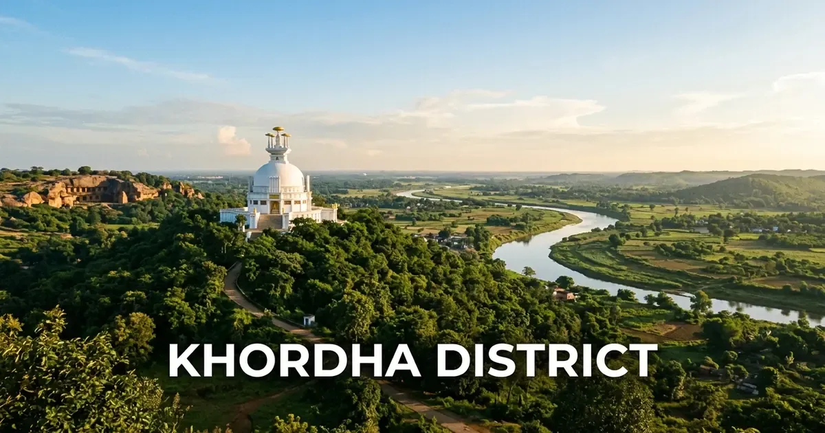
Khordha district occupies a commanding position as the administrative, cultural, and political nerve center of Odisha. Situated along the coastal plains of eastern India, the district houses the state capital Bhubaneswar while preserving an unbroken heritage that spans ancient rock edicts, medieval stone architecture, and colonial resistance.
From the quiet banks of the sacred Daya River where Emperor Ashoka embraced nonviolence to the historic ramparts of Barunei Hill where the Paika warriors ignited India’s earliest organized rebellion against British rule, Khordha embodies the sovereign spirit of the Odia nation.
Today, Khordha bridges deep historical roots with rapid modern progress. It functions as eastern India’s primary educational, healthcare, and information technology corridor while welcoming millions of cultural pilgrims, nature lovers, and heritage enthusiasts every year.
Key Takeaways
- Khordha district spans 2,813 square kilometers across two subdivisions, ten community development blocks, and ten tehsils.
- The district recorded a population of 2,251,673 in Census 2011, with an 86.88 percent literacy rate and Odisha’s highest density at 800 persons per square kilometer.
- Bhubaneswar serves as the state capital and “Temple City of India”, preserving hundreds of ancient Kalinga stone temples across Ekamra Kshetra.
- Barunei Hill in Khordha was the military headquarters of the historic 1817 Paika Rebellion led by Bakshi Jagabandhu against British rule.
- Key attractions include Lingaraj Temple, Dhauli Peace Pagoda, Khandagiri and Udayagiri caves, and Nandankanan Zoological Park.
Introduction to Khordha: The Administrative Core & Sovereign Heartland of Odisha
Khordha district was formally constituted on April 1, 1993, following the administrative reorganisation of the erstwhile undivided Puri district. Despite its relatively recent establishment as an independent administrative unit, Khordha possesses an ancient identity as the last sovereign bastion of independent Odia monarchs.
Geographically, the district extends between 19°40’ N to 20°25’ N latitude and 84°55’ E to 86°05’ E longitude, spanning a total geographical territory of 2,813 square kilometers. It is bounded by Cuttack district to the north and northeast, Puri district to the south and southeast, Ganjam district to the southwest, and Nayagarh district to the west.
The district exhibits unique dual administrative character. While Khordha town serves as the formal district headquarters housing the collectorate, the Smart City of Bhubaneswar serves as the legislative, executive, and judicial capital of Odisha.
| Geographic Metric | Canonical Statistic | Regional Context |
|---|---|---|
| Total Geographical Area | 2,813 sq km | 1.81% of Odisha’s total landmass |
| District Headquarters | Khordha Town (Khurda) | Situated along NH-16, 25 km west of Bhubaneswar |
| State Capital | Bhubaneswar | City of Temples; Smart City administrative capital |
| Revenue Division | Central Division | Headquartered in historic Cuttack |
| Geographic Coordinates | 19°40’ N – 20°25’ N, 84°55’ E – 86°05’ E | Coastal deltaic plain with western lateritic ridges |
| Average Elevation | 45 meters (148 feet) above sea level | Ranging from coastal lagoons to elevated hillocks |
| Forest Cover | 618.67 sq km | Approximately 22% of total district geography |
| Motor Vehicle Registration (RTO) | OD-02 / OD-33 | RTO Bhubaneswar-I (OD-02), RTO-II (OD-33), Khordha |
The climate of Khordha district is tropical, characterized by hot and humid summers, moderate monsoons, and pleasant winter seasons. Annual precipitation averages 1,408 millimeters, with over 75 percent delivered between June and September by the southwest monsoon currents.
Geographical Landscape, Climate & Natural Ecology
The topography of Khordha district presents a dynamic transition between the fertile alluvial deltas of coastal Odisha and the undulating forest ridges of the Eastern Ghats foothills. The eastern tracts consist of fertile riverine floodplains created by distributaries of the Mahanadi system, supporting extensive paddy cultivation and freshwater wetlands.
Toward the west and southwest, the terrain rises into rocky laterite plateaus and isolated granite ridges. Prominent elevations include Barunei Hill near Khordha town, Dhauli Hill along the Daya River, and the twin historic hills of Khandagiri and Udayagiri on the western edge of Bhubaneswar.
The hydrological network of Khordha is anchored by vital river systems:
- Daya River: A prominent distributary of the Kuakhai River that flows southward toward Chilika Lake, forever linked with the Kalinga War of 261 BCE.
- Kuakhai River: A primary branch of the Mahanadi that marks the boundary between Khordha and Cuttack districts before feeding multiple coastal channels.
- Bhargavi River: Branches from the Kuakhai and flows through the southeastern agricultural plains toward Puri district.
- Malaguni River: Originates in the western upland forests, flowing through Khordha block into Chilika Lake.
- Kusabhadra River: Originates near Balianta, flowing southeastward toward the Bay of Bengal coastline.
In the extreme southwestern corner of the district, Khordha borders the northern waters of Chilika Lake around Balugaon and Barkul. This sector features brackish bays, migratory avian feeding grounds, and freshwater wetlands like Mangalajodi, which hosts one of Asia’s largest seasonal waterfowl congregations.
The district’s forest ecology belongs to the North Dry Mixed Deciduous and Tropical Semi-Evergreen forest types. The Chandaka-Dampara Wildlife Sanctuary, located on the northwestern periphery, serves as a vital elephant corridor, while the Barunei Reserve Forest preserves sal, teak, and medicinal plant varieties.
Historical Evolution: From Kalinga War to the Paika Rebellion of 1817
Khordha holds a storied position in Indian history, serving as the stage for epochal transformations in governance, religion, and military resistance across more than two millennia.
The earliest documented chapter unfolded in 261 BCE along the Daya River at Dhauli. Here, Maurya Emperor Ashoka fought the devastating Kalinga War. The immense carnage moved Ashoka toward deep remorse, prompting him to renounce military conquest, adopt Buddhism, and proclaim his philosophy of Dhamma through monumental rock edicts that remain visible on Dhauli Hill today.
During the first century BCE, the Mahameghavahana dynasty rose to prominence under Emperor Kharavela. Rule from Kalinganagara saw extensive patronage of Jain ascetics, commemorated through eighteen rock-cut residential caves on Udayagiri and fifteen caves on Khandagiri hills. Kharavela’s celebrated Hathigumpha inscription, engraved in deep Brahmi script, documents his extensive military expeditions, canal constructions, and public welfare works.
Between the seventh and thirteenth centuries CE, the region blossomed under the Somavamshi and Eastern Ganga dynasties. Bhubaneswar evolved into Ekamra Kshetra, a vast sacred metropolis where royal patrons erected hundreds of monumental sandstone temples dedicated to Lord Shiva, culminating in the 11th-century Lingaraj Temple.
Following the collapse of the Gajapati Empire in 1568 CE, King Ramachandra Deva I established the independent Kingdom of Khordha in 1572 CE. He built a formidable fortress at the base of Barunei Hill and took custody of Lord Jagannath’s worship, earning the title of Dwitiya Indradyumna (Second Indradyumna). For over two centuries, Khordha served as the guardian fortress protecting Jagannath culture from external desecration.
The British East India Company captured Khordha Fort in November 1804 after fierce fighting, deposing King Mukunda Deva II. Colonial policies, oppressive land revenue settlements, and the resumption of rent-free estates generated widespread anger among the traditional martial landed militia, known as the Paikas.
In March 1817, commander Bakshi Jagabandhu Bidyadhar Mohapatra launched the historic Paika Bidroha (Paika Rebellion) from Barunei Hill. Joined by tribal Kondh warriors and local zamindars, the Paikas burned British police stations and seized colonial treasuries.
Colonial garrisons were initially driven completely out of Banapur and Khordha. Although suppressed by late 1818, the Paika Rebellion is celebrated as India’s earliest organized armed uprising against British rule, preceding 1857 by four decades.
Administrative Framework: Subdivisions, Blocks, Tehsils & Constituencies
Administratively, Khordha district operates under a structured governance hierarchy designed to manage both densely populated metropolitan zones and extensive rural agricultural blocks. The district is governed by the Collector and District Magistrate headquartered at Khordha town.
The district is organized into two administrative subdivisions:
- Bhubaneswar Subdivision: Administers the state capital, high-growth technology parks, higher educational institutions, and peripheral suburban gram panchayats.
- Khordha Subdivision: Covers Khordha municipality, rural agricultural blocks, historic forts, and southern towns extending to Chilika Lake.
The ten Community Development (CD) blocks deliver localized rural infrastructure, agricultural extension programs, and primary healthcare across 156 Gram Panchayats.
| Block Name | Headquarters | Tehsils Included | Key Economic & Geographic Focus |
|---|---|---|---|
| Bhubaneswar | Bhubaneswar | Bhubaneswar | Urban development, educational centers, IT corridors |
| Balianta | Balianta | Balianta | Riverine paddy cultivation, dairy farming, vegetable supply |
| Balipatna | Balipatna | Balipatna | Traditional agriculture, bell metal crafts, rural markets |
| Jatni | Jatni (Khurda Road) | Jatni | Railway junction transit hub, IIT Bhubaneswar, trade |
| Khordha | Khordha | Khordha | Administrative offices, industrial estates, Barunei tourism |
| Begunia | Begunia | Begunia | Agricultural trade, pulses cultivation, rural schooling |
| Bolagarh | Bolagarh | Bolagarh | Forestry buffer, agro-processing, rural cottage crafts |
| Tangi | Tangi | Tangi | Highway trade corridor, cashew processing, stone quarries |
| Chilika | Barkul | Chilika | Lake fishery, eco-tourism resorts, water sports navigation |
| Banapur | Banapur | Banapur | Pilgrim tourism (Maa Bhagabati), brass metalworks, betel leaf trade |
In the democratic sphere, Khordha district holds substantial legislative weight in the Odisha Legislative Assembly, electing eight Members of Legislative Assembly (MLAs).
The eight Assembly Constituencies include:
- AC-111 Jayadev (SC): Covers eastern rural blocks including Balianta and Balipatna.
- AC-112 Bhubaneswar Central (Madhya): Encompasses the heart of the capital city, including commercial markets and historic temples.
- AC-113 Bhubaneswar North (Uttar): Covers high-growth technology parks, residential townships, and educational institutions.
- AC-114 Ekamra Bhubaneswar: Includes the heritage Old Town precinct, Lingaraj Temple, and southern suburban wards.
- AC-115 Jatani: Centered around the railway junction city of Jatni and major educational institutes.
- AC-116 Begunia: Covers rural agricultural communities across Begunia and Bolagarh blocks.
- AC-117 Khurda: Encompasses Khordha municipality, Barunei foothill villages, and surrounding rural panchayats.
- AC-118 Chilika: Covers coastal wetlands, fishing communities, and pilgrim towns across Tangi, Chilika, and Banapur blocks.
For national parliamentary elections, the majority of the district forms the Bhubaneswar Parliamentary Constituency (PC-18) in the Lok Sabha.
Official civic administration across the capital is managed by the Bhubaneswar Municipal Corporation, while primary district administration records are cataloged in the Khordha District Administration Portal.
Demographic Profile & Human Capital: Census 2011 Analysis
According to the 2011 Census of India, Khordha district recorded a total population of 2,251,673 residents, making it the second most populous district in Odisha after Ganjam.
The demographic distribution reveals a slight male majority, with 1,167,114 males and 1,084,559 females. This yields an overall sex ratio of 929 females per 1,000 males, slightly below the state average, driven primarily by inward migration of working professionals and students into Bhubaneswar.
Khordha holds the distinction of being the most densely populated district in Odisha, with a population density of 800 persons per square kilometer, far exceeding the state average of 270.
| Demographic Parameter | Census 2011 Value | Percentage / Proportion |
|---|---|---|
| Total Population | 2,251,673 | 100.0% of district populace |
| Male Population | 1,167,114 | 51.8% |
| Female Population | 1,084,559 | 48.2% |
| Urban Population | 1,083,724 | 48.13% |
| Rural Population | 1,167,949 | 51.87% |
| Literacy Rate | 86.88% | Highest among coastal districts |
| Male Literacy | 91.78% | Top tier in eastern India |
| Female Literacy | 81.61% | Significantly above national average |
The district stands out for its high level of human capital and educational attainment. Khordha records an overall literacy rate of 86.88 percent, placing it among the top educational performers in eastern India. Male literacy reaches 91.78 percent, while female literacy stands at 81.61 percent.
Urbanization is exceptionally pronounced compared to neighboring districts. Nearly 48.13 percent of Khordha’s population resides in planned urban centers, driven by the sustained expansion of Bhubaneswar, Jatni, and Khordha municipalities.
The social composition includes Scheduled Castes representing 13.2 percent of the populace, while Scheduled Tribes account for 5.18 percent, concentrated largely in the forested fringe villages of Bolagarh, Begunia, and Banapur.
Ekamra Kshetra & Bhubaneswar: The Ancient Temple Capital
Bhubaneswar, the cultural heartbeat of Khordha district, is widely celebrated as the “Temple City of India.” Known in antiquity as Ekamra Kshetra (the sacred mango grove sanctuary), the city once housed over two thousand stone shrines surrounding the sacred Bindusagar Lake, of which approximately five hundred survive today.
The spiritual and architectural anchor of Ekamra Kshetra is the monumental 11th-century Lingaraj Temple, soaring 180 feet (55 meters) above the historic Old Town skyline. Constructed by the Somavamshi kings and elaborated by the Eastern Gangas, the temple represents the pinnacle of mature Kalinga architecture.
Inside the sanctum sanctorum sits the unique Swayambhu (self-manifested) Lingam, revered as Harihara, representing the harmonious synthesis of Lord Vishnu (Hari) and Lord Shiva (Hara). Devotees can read our in-depth architectural and ritual exploration of the sacred Lingaraj Temple in Bhubaneswar. Architectural archives are documented in the Lingaraj Temple Monograph.
| Historical Period | Temple Landmark | Architectural Significance |
|---|---|---|
| 7th Century CE | Parasurameswar Temple | Early Kalinga style with intricate stone lattice windows |
| 8th Century CE | Vaital Deula | Khakhara style sanctum dedicated to Goddess Chamunda |
| 10th Century CE | Mukteswar Temple | Regarded as the gem of Odishan architecture with torana archway |
| 11th Century CE | Lingaraj Temple | Soaring 180-foot deula, Harihara worship, mature Pancharatha style |
| 11th-12th Century CE | Rajarani Temple | Yellowish sand-stone with finely carved miniature spires |
| 13th Century CE | Ananta Basudeva Temple | Sole ancient Vishnu shrine in Old Town, daily Mahaprasad |
Beyond Lingaraj, the temple quarter features several world-renowned monuments that trace the evolution of Odishan stone craftsmanship:
- Mukteswar Temple: Built in the late 10th century, Mukteswar is often hailed as a jewel of regional art. It is renowned for its arched torana gateway showing Buddhist influence, elegant female figures, and detailed ceiling carvings.
- Rajarani Temple: Dating from the 11th century, Rajarani is famous for its warm yellowish sandstone (Rajaraniya stone) and absence of a reigning presiding deity. Its exterior walls feature masterfully sculpted Alasa Kanyas (indolent maidens), musicians, and floral motifs.
- Parasurameswar Temple: Constructed in the 7th century, it is one of the oldest surviving stone temples in Bhubaneswar, featuring a squat triratha deula, carved reliefs of Ganesha and Kartikeya, and pierced stone window grilles.
- Ananta Basudeva Temple: Erected in 1278 CE along the eastern bank of Bindusagar, this is the only major temple in Bhubaneswar dedicated to Lord Krishna and Balarama. Its kitchen prepares sacred daily Mahaprasad comparable to Puri’s temple culinary traditions.
The sacred water reservoir of Bindusagar Lake sits at the geographical center of Ekamra Kshetra. Spiritual tradition holds that the lake contains droplets gathered from every holy river and tank in India, drawing thousands of devotees for ritual ablutions during the annual Ashokashtami festival.
Historic Monuments: Dhauli Peace Pagoda & Udayagiri-Khandagiri Caves
On the southern outskirts of Bhubaneswar along the bank of the Daya River rises Dhauli Hill, an internationally revered site of peace and historical reconciliation.
It was here that Emperor Ashoka waged the brutal Kalinga War in 261 BCE. Distressed by the catastrophic loss of human life, Ashoka underwent an emotional and spiritual conversion on these plains, renouncing armed conquest in favor of universal peace and spiritual victory (Dharmavijaya).
At the base of the hill rests the celebrated Ashokan Rock Edict, incised into a polished granite boulder. Surmounted by the carved forepart of an elephant emerging from the living rock, this sculpture represents one of India’s oldest continuous stone art monuments. The inscription outlines Ashoka’s compassionate administrative tenets, addressing his provincial judicial officers with the famous declaration: “All men are my children.”
Crowning the summit of Dhauli is the dazzling white Dhauli Shanti Stupa (Peace Pagoda), constructed in 1972 as a collaborative initiative between the Kalinga Nippon Buddha Sangha and the Government of Odisha under the guidance of venerable Japanese monk Nichidatsu Fujii. Travelers can explore complete visiting tips in our historic Dhauli Peace Pagoda guide. Detailed historical context is cataloged in the Dhauli Monument Survey.
On the western horizon of Bhubaneswar stand the twin sandstone ridges of Udayagiri and Khandagiri Caves. Excavated during the 1st century BCE under the patronage of King Kharavela of the Mahameghavahana dynasty, these hills contain thirty-three rock-cut cave complexes serving as monsoon retreats (Lenas) for Jain ascetics.
Udayagiri (Sunrise Hill) contains eighteen caves, led by the double-storied Rani Gumpha (Queen’s Cave), known for its sculpted friezes depicting royal processions, wild animal hunts, and theatrical performances. The famous Hathigumpha (Elephant Cave) houses the seventeen-line Brahmi inscription of Kharavela, detailing year-by-year military conquests, treasury distributions, and public works.
Khandagiri (Broken Hill) contains fifteen caves, notable for the Navamuni Gumpha with relief sculptures of Jain Tirthankaras and the hilltop Digambara Jain Temple built in the 18th century, offering panoramic sunset views across the forested outskirts of Bhubaneswar.
Fortress of Valor: Barunei Hill & the Legacy of Paika Bidroha
Rising prominently behind Khordha town, approximately 25 kilometers west of Bhubaneswar, Barunei Hill stands as the historic spiritual guardian and military stronghold of the Kingdom of Khordha.
The hill derives its sacred name from the twin guardian goddesses, Maa Barunei and Maa Karunei, enshrined in an ancient stone temple located halfway up the forested slope. A perennial freshwater mountain spring known as Swarna Ganga flows past the temple threshold, providing crystal-clear water to pilgrims throughout the year.
Beyond its religious veneration, Barunei Hill is revered across India as the cradle of organized armed resistance against colonial rule. In 1817, the hill served as the strategic military headquarters for the Paika Rebellion (Paika Bidroha) led by Bakshi Jagabandhu.
The rugged granite ravines and dense sal forests of Barunei provided natural fortifications, enabling the peasant-warriors to conduct effective guerrilla skirmishes against British military columns. Historical archives of this movement are preserved in the Paika Rebellion Historical Survey.
At the base of the hill, the Government of Odisha has developed the Paika Memorial & Heritage Park, honoring the sacrifice of leaders such as Buxi Jagabandhu, Krushna Chandra Bhramarabar Ray, and Dinabandhu Samantasinghar.
The site is also a favored retreat for nature enthusiasts. Visitors can hike scenic forest trails leading to the upper plateau, visit the historic caves once used by ascetic hermits, and enjoy picnic grounds beside natural stone pools.
Wildlife & Eco-Tourism: Nandankanan Zoo & Chandaka Sanctuary Buffer
Khordha district contains exceptional biodiversity reserves located in close proximity to its urban centers, balancing rapid modern development with natural conservation.
Located 15 kilometers north of Bhubaneswar near Kanjia Lake, Nandankanan Zoological Park is one of India’s most celebrated wildlife conservation institutions. Established in 1960 and opened to the public in 1969, Nandankanan spans 437 hectares, encompassing a major zoo and a State Botanical Garden.
Nandankanan gained international fame as the first zoo in the world to breed white tigers from normal-colored parents in 1980. The park currently houses over 150 species of animals, birds, and reptiles in open-air, moated enclosures that simulate natural jungle habitats.
Key conservation attractions inside the park include:
- White Tiger Safari & Lion Safari: Guided open-vehicle safaris through natural forested habitats where tigers and Asiatic lions roam freely.
- Kanjia Lake Eco-Zone: A 66-hectare natural wetland designated as a Wetland of National Importance, offering pedal boating and shelter for native water birds.
- Reptile Park & Nocturnal Animal House: Featuring India’s largest captive collection of Indian rock pythons, king cobras, and saltwater crocodiles.
- Aerial Ropeway & Toy Train: Providing eco-friendly transit over Kanjia Lake and through the botanical reserve grounds.
Plan your wildlife excursion with our acclaimed Nandankanan Zoological Park guide. Detailed conservation schedules can be reviewed directly on the Nandankanan Zoological Park Archive.
Adjacent to western Bhubaneswar lies the buffer zone of the Chandaka-Dampara Wildlife Sanctuary. Spanning 193 square kilometers, Chandaka was established in 1982 as an elephant sanctuary to protect roaming herds displaced by urban growth.
The sanctuary features scenic eco-tourism spots including Deras Dam and Jhumka Dam, where visitors can book eco-cottages, walk canopy paths, observe wild elephant towers, and view migratory birds resting along forest reservoirs.
Lakes, Springs & Scenic Getaways: Chilika Barkul, Atri & Deras Dam
Khordha district offers a diverse array of hydrological wonders and scenic recreational retreats, ranging from vast tidal lagoons to therapeutic mineral springs.
In the southwestern corner of the district along National Highway 16, Barkul serves as the primary gateway to the northern waters of Chilika Lake, Asia’s largest brackish lagoon. Barkul houses the main water sports complex operated by the Odisha Tourism Development Corporation (OTDC).
From the jetty at Barkul, motor launches take visitors across the open waters to Kalijai Island, home to the revered Maa Kalijai Temple. The island is steeped in regional folklore and attracts hundreds of thousands of pilgrims during the annual Makar Mela in January.
Other lake highlights accessible from Khordha include Mangalajodi, a community-conserved freshwater marsh where local fishermen guide wooden country boats through reed channels to observe over 150 species of migratory waterfowl. Find itinerary ideas in our scenic Chilika Lake guide.
Situated 42 kilometers west of Bhubaneswar near Baghamari, Atri Hot Sulfur Spring is a unique geological phenomenon. The spring water maintains a consistent year-round temperature of approximately 57°C (135°F) and contains dissolved sulfur compounds known for therapeutic benefits in alleviating skin disorders.
The bathing complex features bathing cubicles constructed around the natural spring, adjacent to the ancient Lord Hatakeswar Temple. During the annual Makar Sankranti festival, thousands gather here to take sacred dips and participate in rural fairs.
For peaceful countryside day trips, the dual reservoirs of Deras Dam and Jhumka Dam, located 20 kilometers west of Bhubaneswar, provide peaceful settings surrounded by sal forests, scenic walking paths, and quiet waters.
Rural Shrines & Cultural Landmarks: Banapur Bhagabati & Sisupalgarh
Beyond the high-profile monuments of Bhubaneswar, rural Khordha harbors ancient religious sanctuaries and archaeological ruins of immense historical value.
In the southern sector of the district near Chilika Lake lies the historic pilgrimage town of Banapur, renowned for the Maa Bhagabati Temple. Built during the 9th century under Somavamshi patronage, the temple enshrines Goddess Bhagabati, revered as an ancient Shakti Peetha.
The temple architecture displays classical Kalinga style, featuring a majestic sanctum and intricately carved torana pillars. Nearby stands the Dakshya Prajapati Temple, celebrated for stone sculptures depicting episodes from the Shiva Purana and fine temple craftsmanship.
On the southeastern outskirts of Bhubaneswar lies Sisupalgarh, one of the best-preserved early historic fortified cities in South Asia. Excavated initially by legendary archaeologist B.B. Lal in 1948, Sisupalgarh dates back to the 3rd century BCE, contemporary with the Kalinga War.
The archaeological site preserves monumental earthen ramparts with square brick defensive gateways, drainage systems, and stone pillar colonnades (The Sixteen Pillars). Scholars identify Sisupalgarh with the ancient metropolis of Tosali or Kalinganagara, providing rare physical evidence of planned urban engineering in ancient Odisha.
In the rural blocks of Balianta and Balipatna, traditional village craftsmanship thrives, producing brass and bell metal utensils, decorative lamps, and stone idols continuing centuries-old family craft lineages.
Economic Landscape: IT Corridors, Industrial Estates & Trade
Khordha district serves as the primary engine of Odisha’s modern economic transformation, combining state administrative functions, high-technology services, heavy manufacturing, and educational infrastructure.
The capital city of Bhubaneswar is recognized as eastern India’s primary Information Technology (IT) and electronic systems hub. Major software technology parks, including Infocity-I at Chandrasekharpur and the expansive Infovalue / Infocity-II at Gaudakasipur, house development centers for multinational technology firms:
- Global IT Anchors: Tata Consultancy Services (TCS), Infosys, Wipro, Tech Mahindra, Mindtree, and Cognizant maintain major campuses employing tens of thousands of software engineers.
- Startup & Innovation Hubs: Initiatives like O-Hub and the KIIT Technology Business Incubator support hundreds of tech startups, artificial intelligence laboratories, and fintech ventures.
Educational services represent another key economic driver. Khordha hosts esteemed national institutes including IIT Bhubaneswar at Jatni, AIIMS Bhubaneswar, NISER (National Institute of Science Education and Research), Utkal University (established in 1943), and extensive private universities like KIIT and SOA.
On the manufacturing front, the Khordha Industrial Estate and Mancheswar Industrial Area support food processing units, plastic manufacturers, pharmaceutical formulation plants, and engineering workshops. The strategic location along National Highway 16 and the major railway junction at Jatni (Khurda Road) facilitates swift freight movement across eastern and southern India.
Culinary Heritage: Pahala Rasgulla, Temple Mahaprasad & Street Food
The culinary culture of Khordha district represents a rich synthesis of ancient temple gastronomy, celebrated highway sweet traditions, and dynamic coastal Odia street cuisine.
The most famous culinary destination in the district is Pahala, an iconic highway sweet hamlet situated along National Highway 16 between Bhubaneswar and Cuttack. For over six decades, a continuous cluster of more than fifty roadside sweet shops has prepared traditional dairy sweets using fresh local cow milk chhena.
Pahala’s signature confection is the world-renowned Pahala Rasgulla. Unlike spongy, white commercial versions, Pahala Rasgulla is soft, lightly brown, and served warm directly from large brass boiling cauldrons. The sweet melts effortlessly in the mouth, carrying the delicate aroma of cardamom and caramelized sugar syrup.
Accompanying Rasgulla at Pahala are two other regional sweet delicacies:
- Chhena Gaja: Dense blocks of kneaded cottage cheese and semolina, fried slowly until golden and coated in a thin crystallized sugar shell.
- Chhena Poda: The celebrated baked cottage cheese cake of Odisha, baked over sal leaves until caramelized with crunchy roasted outer edges.
Within the heritage quarters of Old Town, culinary life centers on Temple Mahaprasad. At the 13th-century Ananta Basudeva Temple, hundreds of earthen pots prepare daily Abhada over wood-fired hearths. The sacred meal features aromatic Ghee Anna, Mitha Dalma (lentils cooked with raw papaya, pumpkin, and roasted cumin), Besara (mustard vegetable curry), and slow-cooked Kheer.
Street food in Bhubaneswar is anchored by the ubiquitous Dahibara Aloodum, consisting of soaked urad dal dumplings bathed in spiced yogurt water (dahi pani), topped with spicy potato-pea curry (aloodum), and finished with chopped onions, fresh coriander, and crispy sev.
Along the lakeside eateries at Barkul and Balugaon, travelers savor freshly caught Chilika Lake Seafood, especially spiced mud crab curry, fried freshwater prawns, and pomfret prepared with home-ground mustard and red chilies.
Transportation & Transit Logistics: Reaching and Navigating Khordha
Khordha district enjoys world-class transportation connectivity, serving as the central transit junction for air, rail, and road travel across Odisha and eastern India.
[!NOTE] Key Transit Hubs of Khordha District:
- Airport: Biju Patnaik International Airport (BBI), Bhubaneswar, offering domestic links to New Delhi, Mumbai, Bengaluru, Kolkata, and direct international flights.
- Rail Terminals: Bhubaneswar Railway Station (BBS) and Khurda Road Junction (KUR), operating round-the-clock express, Rajdhani, and Vande Bharat routes.
- Highway Arteries: National Highway 16 (Chennai-Kolkata corridor), NH-316 (Bhubaneswar-Puri Expressway), and NH-57 (western Odisha link).
The transit overview below highlights key travel links, distances, and modes from regional capitals to Khordha district.
| Origin / Route | Mode | Route Specifications | Distance | Typical Travel Time |
|---|---|---|---|---|
| Kolkata (Howrah) | Air / Rail | Direct flight / Vande Bharat Express | 440 km | 1 hr (Air) / 4 hrs 30 min (Rail) |
| New Delhi | Air / Rail | Direct daily flights / Bhubaneswar Rajdhani | 1,600 km | 2 hrs 15 min (Air) / 21 hrs (Rail) |
| Cuttack | Road / Rail | NH-16 six-lane expressway / Local EMU | 28 km | 40 minutes |
| Puri | Road / Rail | Direct NH-316 four-lane expressway | 60 km | 1 hour 15 minutes |
| Berhampur (Ganjam) | Road / Rail | NH-16 south / Vande Bharat Express | 165 km | 2 hours 45 minutes |
| Sambalpur | Road / Rail | NH-55 / Intercity Superfast Express | 280 km | 5 hours 30 minutes |
Urban commuting within Bhubaneswar is managed by the Mo Bus public bus transit network operated by CRUT (Capital Region Urban Transport), offering clean, air-conditioned city connectivity linking the airport, railway terminals, IT parks, and heritage temple zones.
For regional exploration, state-run OSRTC buses and private luxury coaches operate frequent departures from the Baramunda Inter-State Bus Terminal (ISBT). Regional itineraries can easily connect with the neighboring historic Cuttack district to the north or continue southward along the coast to Puri.
Seasonal Weather & Optimal Travel Timings
Planning a visit to Khordha district requires understanding regional seasonal variations, particularly because outdoor stone temple exploration and wildlife safaris are heavily influenced by temperature and humidity.
The seasonal climate guide below provides month-by-month travel characteristics.
| Season | Calendar Months | Temperature Range | Weather Patterns | Travel Recommendations |
|---|---|---|---|---|
| Winter | October to February | 15°C – 28°C | Mild sunny afternoons, pleasant cool evenings | Peak Travel Window: Optimal for temple walks, Nandankanan safaris, and Chilika birding |
| Summer | March to June | 27°C – 42°C | High heat, dry inland winds, elevated humidity | Limit sightseeing to early mornings; visit museums and air-conditioned complexes |
| Monsoon | July to September | 25°C – 33°C | Heavy tropical downpours, overcast skies | Good for lush rural landscapes and waterfalls; carry rain gear |
The optimal period to explore Khordha district is between October and February. During these winter months, comfortable temperatures make walking through open-air sandstone temple complexes like Lingaraj, Mukteswar, and Khandagiri enjoyable, while cool mornings are ideal for open-jeep safaris at Nandankanan.
This winter window also coincides with major cultural celebrations, including the Toshali National Crafts Mela at Janata Maidan, the Mukteswar Dance Festival in January, and the Rajarani Music Festival.
Accommodation, Local Etiquette & Practical Travel Advice
Khordha district, especially Bhubaneswar, features the most extensive and diverse hospitality infrastructure in Odisha, offering accommodations suitable for every traveler profile.
Upscale business and leisure travelers will find luxury five-star hotels and boutique resorts located along Janpath, Jayadev Vihar, and Nayapalli. Mid-range corporate travelers and families have plentiful options near Bhubaneswar Railway Station, Cuttack Road, and Master Canteen Square.
Budget travelers and pilgrims visiting Ekamra Kshetra can choose from numerous lodges, guest houses, and religious dharamsalas situated around the Old Town and Bindusagar Lake area. Near Chilika Lake at Barkul, the OTDC Panthanivas provides comfortable lakeside lodging with direct access to tourist boat jetties.
To ensure a smooth, respectful, and fulfilling visit, consider these practical recommendations:
- Temple Etiquette at Srimandir and Lingaraj: Non-Hindus are not permitted inside the sanctum sanctorum of Lingaraj Temple. However, visitors of all backgrounds can view the temple complex and architecture from an elevated stone viewing platform erected outside the northern perimeter wall during the British era.
- Dress Code for Religious Sites: Wear modest clothing covering shoulders and knees when visiting living places of worship across Ekamra Kshetra. Remove leather footwear, belts, and wallets before entering sanctum courtyards.
- Wildlife Sanctuary Guidelines: When visiting Nandankanan Zoo or Chandaka Sanctuary, do not feed animals, play loud music, or discard plastic wrappers. Stick strictly to marked walking avenues and guided safari routes.
- Pahala Sweet Purchases: When buying Pahala Rasgulla or Chhena Poda to carry home, request earthen clay pots (handi) or vacuum-sealed food containers to keep the sweets fresh during transit.
Frequently Asked Questions (FAQ) About Khordha District
What is Khordha district famous for?
Khordha district is famous as the sovereign heartland of Odisha, housing the state capital Bhubaneswar with its historic Ekamra Kshetra temples, the ancient Dhauli Peace Pagoda, the 1st-century BCE rock-cut caves of Khandagiri and Udayagiri, the world-renowned white tiger reserve at Nandankanan Zoological Park, and the historic Barunei Hill where the Paika Rebellion of 1817 began.
Which city serves as the district headquarters of Khordha?
Khordha town (Khurda) serves as the official administrative headquarters of the district, housing the Collectorate and district administrative courts. However, the state capital of Odisha, Bhubaneswar, also lies within Khordha district and functions as the state’s legislative and commercial capital.
Why is Lingaraj Temple architecturally significant?
Lingaraj Temple, built during the 11th century by the Somavamshi and Eastern Ganga dynasties, represents the mature pinnacle of classical Kalinga architectural style. Rising 180 feet tall, the temple is unique because its presiding deity is worshipped as Harihara, an auspicious combined manifestation of Lord Vishnu and Lord Shiva.
What was the historic significance of the Paika Rebellion of 1817?
The Paika Rebellion of 1817 was an organized armed uprising led by Bakshi Jagabandhu against the oppressive land policies and rule of the British East India Company at Barunei Hill in Khordha. It predated the 1857 Sepoy Mutiny by forty years and is celebrated across Odisha as India’s earliest organized war of independence.
What is the best time of the year to visit Khordha district?
The optimal time to visit Khordha district is between October and February, when winter temperatures range comfortably between 15°C and 28°C. This season offers pleasant conditions for touring the outdoor sandstone temples of Bhubaneswar, exploring the rock-cut caves, visiting Nandankanan Zoo, and taking boat cruises on Chilika Lake.