Sisupalgarh Fort Bhubaneswar: History, Pillars & Visitor Guide
Explore Sisupalgarh Fort in Bhubaneswar, Odisha. Discover the ancient 3rd century BCE city, Sixteen Pillars, B.B. Lal excavations, timings, and routes.
Sisupalgarh Fort in Bhubaneswar in Khordha district represents one of the largest and earliest preserved early historic fortified cities in South Asia. Dating from the third century BCE to the fourth century CE, this urban complex predates the classical temples of Old Town by over a thousand years.
Laid out in a symmetrical square covering roughly 1.4 square kilometers, the ancient metropolis featured massive earthen ramparts revetted with laterite stone, a defensive water moat fed by the Gangua stream, and eight monumental gateway towers.
Scholars widely identify the site with Kalinganagara, the legendary capital of Emperor Kharavela of the Mahameghavahana dynasty, or the regional administrative center of Tosali established during the Mauryan Empire. Conserved as a monument of national importance under the Archaeological Survey of India, Sisupalgarh offers a profound look into the engineering genius of ancient Kalinga. Official regional travel circuits are also documented through the Odisha Tourism Development Corporation.
Key Takeaways
- Location & Topography: Situated five kilometers southeast of Bhubaneswar Railway Station, near Samantarapur along the Daya River floodplain.
- Urban Scale: Planned square grid of 1.2 by 1.2 kilometers enclosed by defensive ramparts reaching original heights of over nine meters.
- Signature Monument: The Sixteen Pillars, known locally as Shola Khamba, preserves monolithic laterite columns from an ancient royal assembly hall.
- Archaeological Pioneering: Excavated in 1948 by legendary archaeologist B.B. Lal, establishing that the city housed over twenty thousand citizens.
- Access & Hours: Open-air site accessible daily during daylight hours from 6:00 AM to 6:00 PM without any admission charges.
Sisupalgarh at a Glance: Quick Timings & Site Highlights
Sisupalgarh stands apart from the gated medieval temples of Bhubaneswar. Because the ancient defensive ramparts and structural ruins are distributed across open fields, farmland, and rural hamlets, visitors can walk freely among surviving masonry towers and stone columns. The site provides a rare tactile connection to the urban civilization that flourished during the centuries immediately following the Kalinga War.
The table below outlines fundamental visitor logistics, operating parameters, and geographical markers to help you organize a safe and rewarding heritage excursion:
| Metric / Parameter | Visitor Information |
|---|---|
| Site Name | Sisupalgarh Ancient Fortified Settlement |
| District & City | Bhubaneswar, Khordha District, Odisha |
| Nearest Transit Hub | Bhubaneswar Railway Station (5 km) / Airport (7 km) |
| Recommended Visiting Hours | 6:00 AM – 6:00 PM (Daylight exploration) |
| Admission Fee | Free (₹0 for all domestic and foreign visitors) |
| Historical Period | Early Historic (c. 3rd century BCE – 4th century CE) |
| Primary Surviving Feature | Sixteen Pillars (Shola Khamba) & Gateway 4 |
| Suggested Time Needed | 1.5 to 2.5 hours for walking and photography |
Visiting Hours, Admission Rules and Open-Air Access
Sisupalgarh operates without ticket booths or turnstiles. The monuments sit on open elevated ground that remains accessible every day of the week from sunrise to sunset. To avoid intense tropical sun exposure, plan your arrival between 6:30 AM and 9:00 AM, or in the late afternoon between 4:00 PM and 5:30 PM.
Because the site contains exposed archaeological masonry, climbing upon the weathered laterite columns or dislodging stone blocks is strictly prohibited under national conservation laws. Handheld personal smartphone and digital camera photography is freely allowed, but commercial videography requires advance permits from the ASI circle headquarters.
Key Archaeological Remains Visible Across the Site
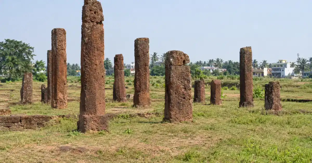
Visitors walking across the fortified perimeter will observe several major structural components surviving above ground level. The most prominent is the central pillared area, known as Area D, where the majestic monolithic pillars stand upright against the sky.
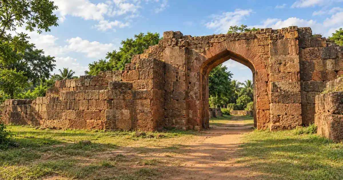
Along the perimeter walls, careful observers can trace the earthen defensive embankments, the sunken contour of the ancient moat, and the stone-paved passageway of Western Gateway 4, which reveals the heavy stone thresholds through which chariots, cavalry, and merchant carts once entered the capital.
Ancient Urban Engineering: The Square Fort, Ramparts & Eight Gateways
The urban design of Sisupalgarh reflects sophisticated mathematical planning and advanced military engineering. The fort was constructed in a near-perfect square, with each rampart wall measuring approximately 1.2 kilometers in length. This geometric precision demonstrates that early Kalingan civil engineers used standardized measurement systems and surveying techniques centuries before the Common Era.
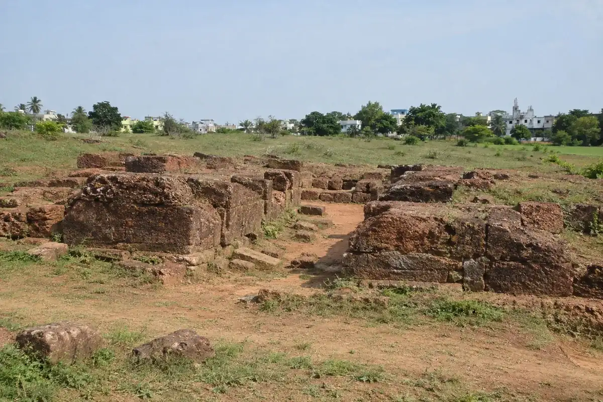
The defenses consisted of composite ramparts made from compacted clay and silt, faced on both sides with neatly dressed laterite stone blocks to prevent erosion during monsoon floods.
[!NOTE] Defensive Fortification Dimensions
- Total Perimeter: 4.8 kilometers forming a square defensive shield.
- Rampart Height: Originally rose between 9 and 12 meters above surrounding plains.
- Defensive Moat: Broad water channel fed by the perennial Gangua stream encircling all four quadrants.
- Gateways: Exactly eight grand entrance bastions, positioned symmetrically with two gates on each wall.
1.2-Kilometer Symmetrical Ramparts and the Gangua Moat
The external defensive network was reinforced by the Gangua stream, known historically as the Gandhavati River, which was deliberately diverted into an artificial moat surrounding the ramparts. This water barrier provided dual benefits: it repelled invading infantry and siege engines, while supplying clean water for drinking, sanitation, and municipal gardens.
The sheer volume of earth moved to erect the embankments implies an organized labor force and a powerful centralized state administration capable of coordinating massive public works.
The Eight Gateways and Laterite Stone Passages
The perimeter wall was pierced by eight monumental stone gates, arranged symmetrically so that two gates guarded each cardinal face. Excavations of Gateway 4 on the western wall revealed that these were not simple doors, but massive defensive architectural complexes.
Each gatehouse featured a long stone passageway flanked by raised guardrooms, a high watchtower, and double-leaf timber doors secured with heavy horizontal crossbars. A narrow side doorway allowed pedestrians to pass through after the main gates were locked for the night.
The Sixteen Pillars (Shola Khamba): The Central Pillared Hall
Near the geographical center of the fortified square stands the most recognizable landmark of Sisupalgarh: a cluster of tall, monolithic laterite pillars known locally as Shola Khamba, or the Sixteen Pillars. These heavy columns once supported the timber superstructure of a grand monumental building.
Archaeologists interpret this complex as a royal audience hall, administrative council chamber, or reception pavilion for visiting ambassadors and merchant delegations.
| Architectural Feature | Specification & Archaeological Detail |
|---|---|
| Local Name | Shola Khamba (Sixteen Pillars) |
| Material | Locally quarried, roughly hewn laterite stone |
| Pillar Height | Approximately 4 to 5 meters above modern ground level |
| Base & Shaft Profile | Square lower bases transitioning to multi-faceted octagonal shafts |
| Capital Features | Squared top tenons designed to receive horizontal wooden tie-beams |
| Functional Context | Central administrative assembly hall or palace reception pavilion |
Monolithic Laterite Columns and Architectural Faceting
Each pillar was quarried as a single massive stone block from regional laterite quarries. The lower portions are squarish and robust to anchor the weight in the foundation soil, while the upper shafts are carefully cut into eight faceted sides.
Near the tops of the pillars, ancient stonemasons carved mortises and tenons designed to interlock with large horizontal beams of timber or stone. This hybrid stone-and-timber construction style is directly comparable to the architecture seen in early Buddhist sites such as Bharhut, Sanchi, and the cave monasteries of Udayagiri.
Royal Audience Chamber or Administrative Assembly Hall
Excavations around Area D revealed that the pillars stood upon a broad elevated platform. The absence of heavy stone walling suggests that the hall featured open sides with wooden lattice screens or rich fabric curtains, allowing cool breezes to circulate during the humid coastal summers.
In this central hall, regional rulers, whether Mauryan governors or Mahameghavahana monarchs, held public court, managed tax revenues, and received foreign emissaries trading along the Bay of Bengal coastline.
Excavation History: B.B. Lal’s 1948 Discovery & Modern Discoveries
Sisupalgarh holds an honored position in modern Indian archaeology. In 1948, shortly after Indian independence, renowned archaeologist Braj Basi Lal of the Archaeological Survey of India initiated the first systematic modern excavation at the site.
Lal’s pioneering work established modern stratigraphic methods in Indian archaeology, providing the first reliable chronological anchor for early historical civilizations in eastern India.
[!NOTE] Excavation Chronology at Sisupalgarh
- 1948–1949 (B.B. Lal, ASI): Excavated Gateway 4 and defensive ramparts, establishing occupational antiquity from the 3rd century BCE.
- 1966 (ASI Surveys): Documented extensive domestic pottery, punch-marked coins, and structural brick foundations.
- 2005–2008 (Deccan College & UCLA): Joint geophysical mapping and excavations by R.K. Mohanty and Monica L. Smith detailing urban street grids and residential density.
B.B. Lal’s Groundbreaking 1948 Excavation Campaign
B.B. Lal excavated the western gateway, cutting deep stratigraphic trenches across the northern rampart. His team uncovered multiple occupational phases, demonstrating continuous human habitation from approximately the third century BCE to the fourth century CE.
Among the critical artifacts recovered were distinctive Northern Black Polished Ware, Mediterranean rouletted pottery demonstrating maritime trade with the Roman world, punch-marked silver coins, and glass beads. Lal’s findings proved that Sisupalgarh was an affluent commercial metropolis long before the rise of the early medieval dynasties.
Deccan College and UCLA Findings on Urban Density
Between 2005 and 2008, a joint expedition directed by R.K. Mohanty of Deccan College, Pune, and Monica L. Smith of the University of California, Los Angeles, resumed excavations using modern geomagnetic surveying and satellite mapping.
Their research revealed dense residential quarters, stone drainage canals, household pottery kilns, and gold ornaments. Their demographic analysis estimated that Sisupalgarh accommodated between twenty and twenty-five thousand residents at its peak, making it one of the largest populated cities in South Asia during the early centuries of the Common Era.
Sisupalgarh in Kalinga History: Kharavela’s Capital & Tosali Connections
The historical identity of Sisupalgarh remains one of the most compelling subjects in Indian epigraphy. Most modern historians agree that Sisupalgarh represents Kalinganagara, the majestic fortified capital city described in the celebrated Hathigumpha inscription of Emperor Kharavela at the nearby Udayagiri caves.
The inscription describes how Kharavela repaired the gateways, fortifications, and water reservoirs of his capital after they were damaged by a fierce cyclonic storm in the first century BCE.
Epigraphical Synchronism: Kalinganagara and Tosali
- The Hathigumpha Evidence: Kharavela records spending hundreds of thousands of coins restoring the storm-damaged defenses of Kalinganagara, matching the laterite repairs identified by B.B. Lal at Gateway 4.
- The Ashokan Connection: Situated barely three kilometers south of Sisupalgarh lies Dhauli Hill, where Emperor Ashoka engraved his Special Kalinga Edicts addressed to the royal judicial officers of Tosali.
King Kharavela and the Splendor of Kalinganagara
Under Kharavela’s rule, Kalinga expanded into a dominant military power whose influence stretched across northern, central, and southern India. The wealth gained from royal campaigns and maritime spice trade flowed directly into Kalinganagara, funding paved stone avenues, palace gardens, and monastic halls.
The monumental scale of Sisupalgarh’s eight gateways reflects the military prestige of an emperor who took pride in rebuilding his capital to withstand both natural disasters and foreign sieges.
Proximity to Dhauli Hills and Ashoka’s Tosali Edicts
The close geographic relationship between Sisupalgarh and Dhauli Hill provides crucial insight into the Mauryan administrative network. The rock edicts at Dhauli make specific reference to the royal city of Tosali, ordering royal officials to administer justice impartially.
Given that Sisupalgarh is the only fortified metropolis of that antiquity within the surrounding river basin, many archaeologists conclude that Tosali and Kalinganagara occupied the same fortified footprint under successive imperial dynasties.
Sisupalgarh vs Barabati Fort: Ancient Bastion vs Medieval Fortress
Odisha is home to two celebrated fortresses separated by fifteen centuries of architectural evolution: Sisupalgarh in Bhubaneswar and Barabati Fort in Cuttack. Comparing these two sites illuminates the dramatic changes that reshaped military defense, materials, and municipal planning across Odisha’s history.
The table below contrasts the distinct epochs, architectural materials, and functions of these twin monuments:
| Comparison Attribute | Sisupalgarh Fort (Bhubaneswar) | Barabati Fort (Cuttack) |
|---|---|---|
| Historical Period | Early Historic (c. 3rd century BCE – 4th century CE) | Medieval (c. 14th – 18th century CE) |
| Patron Dynasties | Mauryan, Mahameghavahana (Kharavela) | Eastern Ganga, Suryavamsi Gajapati |
| Primary Materials | Compacted earth, red brick, and laterite stone | Khondalite stone, laterite, and medieval lime |
| Urban Function | Planned residential metropolis of 25,000 citizens | Royal royal palace citadel and garrison fort |
| Water Defense | Natural Gangua river moat around a square plan | Wide rectangular stone moat fed by Mahanadi |
| Visible Monument | Monolithic Sixteen Pillars (Shola Khamba) | Nine-story palace mound and arched gateway |
Chronological Divide: 3rd Century BCE vs 14th Century CE
Sisupalgarh was built during the dawn of urban civilization in eastern India, when military builders relied on massive earthen ramparts revetted with laterite stone. Its purpose was to defend an entire civilian population and merchant guild community inside a self-contained square metropolis.
Barabati Fort was constructed during the high medieval period under the Ganga kings, designed as a compact military fortress and royal residence with a nine-story palace tower. It guarded the strategic river confluence between the Mahanadi and Kathajodi rivers.
Urban Design: Civil Metropolis vs Royal Defensive Citadel
At Sisupalgarh, residential streets, craft workshops, and private houses were arranged in an open grid inside the ramparts. In contrast, Barabati functioned primarily as an aristocratic military bastion surrounded by deep water moats to protect the royal family and high military commanders.
Heritage travelers exploring defense architecture can visit our comprehensive profile of Barabati Fort in Cuttack to understand medieval fortification, as well as our broader guide to Khordha district attractions.
How to Reach Sisupalgarh, Heritage Route & Practical Visitor Tips
Sisupalgarh is located on the southeastern boundary of modern Bhubaneswar, making it exceptionally easy to visit from anywhere in the capital city. The ruins sit just off the main Puri bypass road, reachable in less than twenty minutes from the central commercial district.
The transit table below provides convenient route information, travel distances, and estimated drive times from key hubs:
| Origin / Departure Point | Driving Route & Main Roads | Distance | Travel Duration |
|---|---|---|---|
| Bhubaneswar Railway Station | Via Rajmahal, Kalpana Square & Samantarapur | 5 km | 15 minutes |
| Biju Patnaik Airport (BBI) | Via Airport Road, Forest Park & Samantarapur | 7 km | 20 minutes |
| Old Town (Lingaraj Temple) | Via Bindusagar East Road & Daya Canal | 4 km | 12 minutes |
| Dhauli Shanti Stupa | Direct connection via Daya River bridge | 3 km | 8 minutes |
| Cuttack City Center | NH-16 southbound via Rasulgarh & Puri bypass | 32 km | 45 minutes |
Route Directions from Master Canteen and Old Town
From Master Canteen or Bhubaneswar Railway Station, drive south through Rajmahal Square and proceed past Kalpana Square toward the historic Old Town suburb of Samantarapur. At Samantarapur Junction, turn eastward onto the road leading toward Sisupalgarh village.
Local auto-rickshaws and app-based taxis (Ola and Uber) operate regularly across this route. When hiring an auto-rickshaw, request the driver to take you specifically to the “Shola Khamba” or the “Puruna Killa” of Sisupalgarh, as these names are familiar to local residents.
Ideal Half-Day Heritage Circuit with Dhauli Shanti Stupa
Because Sisupalgarh requires about an hour to explore on foot, it pairs smoothly with other ancient landmarks along the Daya River corridor:
- 7:00 AM – 8:30 AM: Arrive early at Sisupalgarh; walk along the ancient western gateway, photograph the Sixteen Pillars, and trace the laterite ramparts under morning light.
- 8:30 AM – 9:00 AM: Drive three kilometers southward across the Daya River floodplains to Dhauli Hill.
- 9:00 AM – 10:30 AM: Inspect the Ashokan Rock Edicts and ascend the hilltop to visit the peace pagoda at Dhauli Giri Hills Shanti Stupa.
- 10:30 AM – 12:00 PM: Continue into Old Town to explore 7th-century Kalinga temple architecture at Parasurameswara and Mukteswara.
- 12:00 PM onwards: Conclude your morning with an authentic Odia vegetarian lunch in the capital.
For broader travel inspiration spanning ancient warfare, royal dynasties, and cultural monuments, explore our definitive analysis of the Kalinga War history and the complete history of Odisha.
Frequently Asked Questions About Sisupalgarh Fort
What is the historical significance of Sisupalgarh Fort?
Sisupalgarh is an ancient fortified metropolis dating from the third century BCE to the fourth century CE, recognized as one of the earliest planned urban centers in South Asia. Historians identify it as the royal capital Kalinganagara of King Kharavela or the Mauryan administrative center of Tosali.
Who excavated Sisupalgarh Fort in Bhubaneswar?
Renowned archaeologist B.B. Lal conducted the first systematic modern excavation at Sisupalgarh in 1948 for the Archaeological Survey of India. Decades later, between 2005 and 2008, joint expeditions by Deccan College, Pune, and UCLA mapped residential areas and street layouts.
What are the Sixteen Pillars or Shola Khamba at Sisupalgarh?
The Sixteen Pillars are monolithic laterite stone columns standing in the central Area D of the fort, featuring square bases and octagonal faceted shafts. Archaeologists interpret these pillars as the structural remains of a grand royal assembly hall or reception pavilion.
What are the visiting hours and entry fees for Sisupalgarh?
Sisupalgarh is an open-air archaeological landscape with free entry for all domestic and international visitors. The site is best explored during daylight hours between 6:00 AM and 6:00 PM when natural light illuminates the ancient stone carvings and ramparts.
Was Sisupalgarh the ancient capital of King Kharavela?
Yes, prominent historians identify Sisupalgarh with Kalinganagara, the capital described in Emperor Kharavela’s first-century BCE Hathigumpha inscription. The inscription notes that Kharavela restored the gateways and storm-damaged ramparts of his capital city with enormous royal expenditures.
How far is Sisupalgarh Fort from Dhauli Hills?
Sisupalgarh is located approximately three kilometers north of Dhauli Hill, reachable in about eight minutes by road across the Daya River floodplain. Travelers can easily combine both destinations in a single morning heritage tour from central Bhubaneswar.