Malkangiri District: Balimela Dam, Bonda Hills & Travel Guide
Comprehensive guide to Malkangiri district in Odisha. Discover Balimela reservoir, Gurupriya Bridge, Bonda hills, Satiguda Dam, and southern travel routes.
Malkangiri district forms the southernmost frontier of Odisha, extending between Chhattisgarh and Andhra Pradesh. Spanning 5,791 square kilometers across the Eastern Ghats, the territory is celebrated for its tribal cultures and hydroelectric reservoirs. Established on October 2, 1992 from undivided Koraput, the district links the Deccan tableland with coastal plains.
The district possesses ancient cultural resonance as part of the legendary Dandakaranya forest described in classical Indian epics. In addition to its expansive Balimela reservoir and the landmark Gurupriya Bridge, Malkangiri preserves the ancestral highland home of the Bonda tribe across the remote Bonda Hills.
Key Takeaways
- Malkangiri spans 5,791 square kilometers across seven community development blocks and seven revenue tehsils in southernmost Odisha.
- The district recorded a population of 613,192 in Census 2011, with a sex ratio of 1,020 females per 1,000 males and over 57 percent tribal population.
- Home to the engineering marvel of Balimela Dam and the historic 910-meter Gurupriya Bridge connecting Swabhiman Anchal.
- Anchors the highland homeland of the indigenous Bonda (Remo) Particularly Vulnerable Tribal Group across the Bonda Hills.
- Preserves sacred cultural landmarks including Manyamkonda (center of the biennial Bada Jatra), Satiguda Dam, and Motu river confluence.
Introduction and Geographic Setting
Malkangiri district occupies the southernmost tip of Odisha, extending between 17°45’ N and 18°40’ N latitude and 81°10’ E and 82°00’ E longitude. The administrative headquarters is situated at Malkangiri town, located in the central valley basin of the Potteru River.
The district borders Koraput District northern parent territory to the north and northeast. It adjoins Chhattisgarh to the west and Andhra Pradesh to the south and east. Elevations range from 45 meters at Motu to over 1,200 meters across the high ridges of the Bonda Hills.
The hydrological network of Malkangiri is anchored by the perennial Sabari and Sileru river systems, both major tributaries of the Godavari River. The Sileru River feeds the vast Balimela hydroelectric reservoir, while the Sabari River forms the international border with Chhattisgarh. Smaller tributary streams, including the Potteru, Gurupriya, and Kolab rivers, drain fertile crop basins across the central and southern tehsils.
Protected forests cover more than forty-five percent of the total district geography. Dense stands of teak, sal, bamboo, and medicinal flora mantle mountain ridges, forming essential corridors for wildlife. Travelers crossing Malkangiri experience rolling river basins, mist-clad mountain passes, blue reservoirs, and lively weekly tribal markets.
At a Glance: District Profile and Key Metrics
A review of fundamental geographic, demographic, and civic indicators demonstrates Malkangiri’s identity as a resource-rich frontier district undergoing transformative infrastructure growth. Baseline figures from Census 2011 and official state records provide a reliable factual overview.
The district functions under the administrative jurisdiction of the Revenue Divisional Commissioner based in Ganjam District southern division coastal center at Berhampur.
| Administrative Parameter | Official Metric | Governing Authority / Source |
|---|---|---|
| District Headquarters | Malkangiri Town | Government of Odisha |
| Establishment Date | October 2, 1992 | Revenue and Disaster Management Department |
| Total Geographic Area | 5,791 sq km | Malkangiri District Demographic Monograph |
| Population (2011 Census) | 613,192 | Registrar General and Census Commissioner |
| Population Density | 106 persons / sq km | Directorate of Census Operations, Odisha |
| Sex Ratio | 1,020 females per 1,000 males | Census of India 2011 |
| Literacy Rate | 48.54% (Male: 59.07%, Female: 38.28%) | State Literacy Mission Authority |
| Tribal Population (ST) | 57.4% (Bonda, Koya, Didayi, Dharua) | Scheduled Castes & Scheduled Tribes Research Institute |
| Administrative Subdivisions | 1 (Malkangiri) | District Collectorate Administration |
| Community Development Blocks | 7 Blocks | Panchayati Raj Department, Odisha |
| Revenue Tehsils | 7 Tehsils | Board of Revenue, Odisha |
| Urban Local Bodies | Malkangiri Municipality, Balimela NAC | Housing and Urban Development Department |
| Vehicle Registration Code | OD-30 | State Transport Authority, Odisha |
| Assembly Constituencies (MLA) | 2 Seats (Malkangiri ST, Chitrakonda ST) | Election Commission of India |
| Parliamentary Constituency (MP) | Nabarangpur Lok Sabha (Seat 12 - ST) | Election Commission of India |
| Major Hydroelectric Reservoir | Balimela Reservoir (Sileru River) | Odisha Power Generation Corporation |
| Major River Systems | Sabari, Sileru, Potteru, Kolab | Department of Water Resources, Odisha |
With a positive sex ratio of 1,020 females per thousand males, Malkangiri reflects strong gender equity rooted in egalitarian tribal traditions. Official government notifications and visitor advice are published on the Odisha Tourism Official Portal and district records. Crop farming, minor forest produce gathering, and inland fisheries sustain most households.
Historical Evolution: Ancient Dandakaranya, Tribal Kingdoms and Freedom Struggle
The history of Malkangiri reaches back into early antiquity, where local traditions identify its dense forests with the Dandakaranya of the Ramayana epic. According to regional folklore, Lord Rama, Mata Sita, and Lakshmana traversed these wild woodlands during their fourteen-year exile.
In the medieval period, the territory was ruled by local tribal chieftains and feudatory rajas under the suzerainty of the Gajapatis of Odisha and later the kings of Jeypore. The dense terrain and formidable hill fortresses allowed indigenous communities like the Koyas and Bondas to preserve their sovereign customs and self-governing village councils largely undisturbed by outside empires.
During the nineteenth century, Malkangiri became an active center of tribal resistance against British colonial oppression. In 1880, the legendary Koya leader Tama Dora launched an armed rebellion against exploitative forest laws and forced labor. Leading guerilla bands across the Sabari valley, Tama Dora liberated vast forest tracts before falling heroically in battle against colonial troops.
During the Quit India Movement in 1942, another tribal hero, Laxman Nayak of the neighboring Koraput-Malkangiri forest tract, led peaceful peasant marches against British authorities. Nayak was subsequently executed by colonial rulers at Berhampur jail in August 1943, immortalizing his name in India’s struggle for independence. The territory merged with independent Odisha in 1948 as part of undivided Koraput.
Administrative Framework: Subdivisions, 7 Blocks and Governance
Administrative governance in Malkangiri operates under a single revenue subdivision headquartered at Malkangiri town. The Collector and District Magistrate oversees administrative coordination, public distribution services, highway expansion, and tribal development schemes.
Rural administration is organized across seven community development blocks and seven matching revenue tehsils: Malkangiri, Kalimela, Korukonda, Mathili, Khairaput, Chitrakonda, and Kudumulugumma. The district shares parliamentary representation with Nabarangpur District parliamentary partner under the Nabarangpur Lok Sabha constituency.
The table below outlines the seven community development blocks along with their administrative and economic profiles.
| Block Name | Headquarters | Gram Panchayats | Inhabited Villages | Dominant Economic Base |
|---|---|---|---|---|
| Malkangiri | Malkangiri Town | 25 | 114 | Commercial Services, Retail Trade, Irrigated Paddy |
| Kalimela | Kalimela | 24 | 128 | Potteru Valley Agriculture, Groundnut, Pulse Crops |
| Korukonda | Korukonda | 21 | 142 | Paddy Farming, Livestock, Rural Haat Commerce |
| Mathili | Mathili | 22 | 136 | Maize Cultivation, Forest Produce, Cashew Orchards |
| Khairaput | Khairaput | 18 | 98 | Bonda Highland Forestry, Millets, Spices |
| Chitrakonda | Chitrakonda | 18 | 152 | Hydroelectric Power, Reservoir Fisheries, Eco-Tourism |
| Kudumulugumma | Kudumulugumma | 19 | 118 | Alluvial Paddy, Vegetable Farming, Dairy |
Urban civic services are provided by the Malkangiri Municipality and the Balimela Notified Area Council (NAC). Two legislative assembly constituencies, Malkangiri (Seat 146 - ST) and Chitrakonda (Seat 147 - ST), represent the district within the Odisha Vidhan Sabha.
Top Tourist Attractions: Balimela Dam, Gurupriya Bridge and Satiguda
Malkangiri preserves a remarkable collection of natural wonders, engineering feats, and religious landmarks that attract travelers seeking offbeat destinations. Visitors can explore azure lake reservoirs, modern bridge spans, and historic cave temples.
Balimela Dam and Reservoir
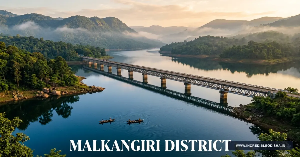
Located at Chitrakonda on the Sileru River, the Balimela Dam represents one of eastern India’s major hydroelectric projects. The massive masonry dam impounds an enormous freshwater reservoir covering over 180 square kilometers, surrounded by the emerald folds of the Eastern Ghats.
The reservoir generates substantial hydroelectric power through underground powerhouses while feeding extensive irrigation canals across the Potteru river valley. Travelers can enjoy commanding panoramas of the azure water from hilltop viewpoints, watch speedboats glide across the lake, and take peaceful evening walks along the landscaped lakeside promenade.
Gurupriya Bridge and Swabhiman Anchal
Inaugurated in July 2018, the landmark 910-meter Gurupriya Bridge spans the Balimela reservoir, connecting the mainland with 151 formerly cut-off tribal villages known as Swabhiman Anchal. For nearly five decades following the construction of the Balimela dam, residents of this area were accessible only by slow wooden motor launches.
The bridge stands as a symbol of human perseverance and engineering excellence, constructed through challenging terrain and deep water channels. Crossing the bridge offers magnificent panoramic views of the water expanse and surrounding wooded hills. The bridge has facilitated new roads, electricity lines, rural clinics, and community eco-tourism across the peninsula.
Satiguda Dam and Eco-Park
Situated just eight kilometers from Malkangiri town, Satiguda Dam forms an attractive earth reservoir on the Satiguda stream. Ringed by wooded hill slopes, the reservoir provides irrigation and municipal drinking water to the district headquarters.
The site features a landscaped eco-park, boating facilities, and a deer park maintained by the state forest department. A prominent natural attraction within the complex is an ancient cave temple dedicated to Lord Shiva, carved inside huge granite boulders where natural water drips continuously over the sacred linga.
Motu Tri-Junction and River Confluence
Located ninety-six kilometers south of Malkangiri town, Motu marks the southernmost tip of Odisha. Here, the Sabari and Sileru rivers merge in a sacred confluence before flowing into the Godavari River.
Motu forms an exceptional geographic tri-junction where the state borders of Odisha, Andhra Pradesh, and Chhattisgarh meet. Travelers visit to stand at the geographic extremity of the state, visit the historic Jagannath temple in Motu, and observe wooden river ferries transporting trade goods across interstate channels.
Ammakunda Natural Rock Pool
Located in Khairaput block along the Sileru River, Ammakunda forms a scenic natural gorge where water cascades into deep stone pools. The natural rock pools are inhabited by large, friendly mahseer fish that swim close to visitors.
According to local tribal beliefs, these fish are sacred and protected from harm. Visitors routinely feed puffed rice and grams to the fish, which gather in large schools near the water’s surface. Shaded by dense riverbank trees, Ammakunda provides a peaceful retreat for nature lovers.
Manyamkonda Hill Shrine
Situated ninety kilometers from Malkangiri near Kalimela, Manyamkonda is a sacred hilltop shrine revered as the divine seat of Lord Kanhamaraju, Lord Bima, and Goddess Nilendri. Worshipped primarily by the Koya tribal community, the deities represent divine guardians of forest life and agricultural prosperity.
The hill shrine hosts the celebrated biennial Bada Jatra festival, drawing hundreds of thousands of pilgrims from Odisha, Andhra Pradesh, and Chhattisgarh for traditional sword processions and sacred dances.
| Attraction Name | Distance from HQ | Primary Feature / Significance | Recommended Season |
|---|---|---|---|
| Balimela Dam | 35 km (Chitrakonda) | Hydroelectric reservoir, Mountain viewpoints | October to March |
| Gurupriya Bridge | 42 km (Chitrakonda) | 910m bridge span, Swabhiman Anchal gateway | October to February |
| Satiguda Dam & Caves | 8 km | Reservoir lake, Boating, Shiva cave temple | October to March |
| Motu Tri-Junction | 96 km | Sabari-Sileru river confluence, Southernmost point | November to February |
| Ammakunda | 50 km (Khairaput) | Natural stone pools, Tame sacred mahseer fish | October to March |
| Manyamkonda Shrine | 90 km (Kalimela) | Sacred Koya shrine, Biennial Bada Jatra | November to March |
| Bonda Hills Foothills | 60 km (Mudulipada) | Indigenous tribal highlands, Scenic vistas | October to February |
Wild Frontiers and Highland Wonders: The Bonda Hills and River Gorges
Malkangiri preserves some of the most remote and ecologically intact forest ranges in eastern India. The high plateau of the Bonda Hills, rising above 1,000 meters in Khairaput block, forms an extraordinary natural sanctuary.
The Bonda people, known autonymously as the Remo, are an ancient Austroasiatic tribal group classified as a Particularly Vulnerable Tribal Group (PVTG). Living in thirty-two highland villages across the Bonda Ghati, they have maintained unique customs, language, and social structures for thousands of years.
The high mountain ridges feature mixed moist deciduous forests, dense bamboo brakes, wild mango trees, and perennial freshwater springs. Temperatures on the plateau remain pleasantly cool throughout the year, with winter nights often dipping to 8°C.
Wildlife surveys in the dense hill tracts document Asian elephants, leopards, sloth bears, Indian gaurs (bison), spotted deer, barking deer, wild boars, and Indian giant squirrels. Birdwatchers can encounter rare forest birds including the Malabar pied hornbill, emerald dove, scarlet minivet, and crested serpent eagle.
The forest department manages strict conservation guidelines to preserve biodiversity and protect indigenous tribal cultures from commercial exploitation. Guided nature walks along approved peripheral buffer zones offer travelers opportunities to appreciate the extraordinary wilderness while respecting tribal autonomy.
Agriculture, River Basins and Forest Economy
The economy of Malkangiri rests on subsistence farming, canal-fed agriculture, and the harvesting of minor forest produce. More than seventy percent of working families depend on agriculture and forest resources for their livelihood.
The construction of the Potteru Irrigation Project has transformed vast tracts of the central and southern valleys into fertile, multi-cropped agricultural land. Water delivered through hundreds of kilometers of main and distributary canals allows farmers to harvest two successful crops annually.
Paddy represents the chief agricultural staple, grown extensively across both monsoon and winter seasons. Farmers cultivate high-yielding rice varieties alongside traditional scented landraces that supply district markets.
In the highland blocks of Khariar, Mathili, and Khairaput, finger millet (mandia or ragi), little millet (suan), and maize form vital food crops. The Odisha Millets Mission has expanded organic millet farming across tribal villages, enhancing nutrition and rural incomes.
Minor forest produce represents an essential economic lifeline for tribal families. Collectors harvest mahua flowers for brewing and food, tendu leaves for beedi rolling, tamarind pods, sal seeds, and medicinal herbs. These forest goods are sold through village cooperatives and weekly rural markets.
Tribal Arts, Bonda Ornaments and Rural Handicrafts
Malkangiri preserves distinctive indigenous craft traditions that reflect the artistic genius of its diverse tribal populations, connecting culturally with the Rayagada District tribal cultural corridor.
Foremost among these traditions is the exquisite personal ornamentation of Bonda women. Bonda craftswomen weave tiny glass and brass beads into dense, colorful necklaces that cover the neck and chest. They hammer brass metal into wide collar rings called Khagla, worn around the neck alongside aluminum armlets.
Bonda women also weave traditional short skirts known as Ringa on simple backstrap waist looms. Crafted from wild plant fibers extracted from the Kerang bark tree and dyed with natural forest roots, the fabric features bright horizontal bands of blue, red, and yellow.
The Koya tribe excels in crafting ceremonial musical instruments and headgear. Koya craftsmen carve long wooden flutes, hollowed wooden drums (dhol), and dramatic buffalo-horn headdresses worn by men during festive dances.
Village artisans across the district produce functional bamboo baskets, grain storage bins, winnowing trays, and hand-carved wooden domestic implements. In forest fringe settlements, women stitch dried sal leaves into sturdy dining plates that supply community gatherings.
| Craft Practice | Indigenous Community / Center | Finished Artifacts | Primary Raw Materials |
|---|---|---|---|
| Bonda Bead Ornaments | Bonda Hills (Khairaput) | Multicolored bead necklaces, Khagla collars | Glass beads, Brass wire, Aluminum |
| Ringa Cloth Weaving | Mudulipada, Bonda Hills | Traditional short skirts, Waist fabrics | Kerang bark fiber, Natural dyes |
| Bison-Horn Headdresses | Koya tribal villages (Kalimela) | Ceremonial dance headdresses, Masks | Wild buffalo horns, Cowrie shells |
| Tribal Musical Flutes | Mathili, Korukonda | Carved bamboo flutes, Mahuri pipes | Seasoned bamboo, Brass mouthpieces |
| Bamboo Utility Crafts | Kudumulugumma, Mathili | Winnowing trays, Storage bins, Mats | Split green bamboo, Wild twine |
| Sal Leaf Utensils | Forest fringe hamlets | Disposable dinner plates, Bowls | Sal leaves, Cotton thread |
Folk Culture, The Biennial Bada Jatra and Koya Traditions
The cultural life of Malkangiri is defined by dynamic folk performances, sacred pilgrimages, and ancient tribal gatherings. Festive rituals celebrate agricultural cycles, seasonal transitions, and forest protection deities.
The Biennial Bada Jatra
The most celebrated festival in Malkangiri is the Bada Jatra, observed every two years during the month of Magha (January–February). Originating at the sacred hill shrine of Manyamkonda, the festival commemorates Lord Kanhamaraju, Lord Bima, and Goddess Nilendri.
During the festival, sacred brass emblems, royal umbrellas, and consecrated swords are carried in a grand walking procession from Manyamkonda through villages to Malkangiri town. Hundreds of thousands of devotees from Odisha, Chhattisgarh, and Andhra Pradesh walk alongside the procession. The pilgrimage features thunderous drum rhythms, traditional bison-horn dances, and continuous community feasts.
Koya Bison-Horn Dance
The Bison-Horn Dance of the Koya tribe ranks among the most visually striking folk dances in India. Performed during marriage ceremonies and harvest celebrations, the dance features male dancers wearing towering headdresses fitted with genuine wild buffalo horns and long feathers.
Carrying heavy brass and iron drums, the men beat energetic rhythmic patterns while stomping in synchronized circles. Koya women, dressed in colorful cotton sarees with brass ankle bells, link arms to form graceful outer rings, chanting traditional folk melodies celebrating nature and community harmony.
Weekly Tribal Haats
Weekly rural haats serve as the social and commercial foundation of community life in Malkangiri. Important haats take place at Mudulipada, Mathili, Kalimela, and Chitrakonda.
At these markets, highland tribes like the Bondas descend from mountain ridges to trade forest honey, millets, ginger, and wild fruits for salt, dried fish, kerosene, and cloth. The market squares provide lively settings where neighbors meet to share community news and celebrate friendships.
Culinary Heritage: Millets, Mahua and Indigenous Forest Flavors
The culinary culture of Malkangiri reflects a deep harmony with the forest and soil. Daily meals emphasize wholesome millets, wild forest produce, and fresh river fish.
Mandia Peja, a nutritious fermented porridge made from finger millet powder cooked with broken rice water, forms the traditional daily breakfast across tribal villages. Cool, easily digestible, and rich in calcium, it sustains farmers through long hours of field labor.
In the valleys, Pakhala remains the preferred meal during warm months. Fermented rice is served with roasted forest tubers, crushed dried fish (Sukhua Bhaja), and stir-fried wild leafy greens collected from stream banks.
Fresh river fish caught from the Balimela reservoir and Sabari River features prominently in local cooking. Fish is often roasted in sal leaves over open wood fires or prepared as a fragrant curry simmered with wild tamarind and green chilies.
During seasonal festivals, households prepare traditional sweets including Kakara Pitha and Arisa Pitha made from fresh rice flour and jaggery. The golden blossoms of the Mahua tree (Madhuca longifolia) are collected in spring, sun-dried, and cooked into sweet breads or brewed into traditional Mahua beverages enjoyed during festive dances.
Transportation Logistics, Southern Corridors and Border Crossings
Malkangiri enjoys improving overland connectivity, transforming from a remote frontier into an accessible regional corridor linking southern Odisha with neighboring states. Modern highway networks and bridge engineering ensure dependable year-round travel.
Highway Corridors
National Highway 326 (NH-326) serves as the primary transportation backbone through Malkangiri district. Originating near Aska and Rayagada, the highway passes through Koraput, Jeypore, Boipariguda, and Mathili before cutting through Malkangiri town and continuing south to Motu. This well-maintained highway allows motorists to travel from Jeypore to Malkangiri town in about three hours.
State Highway 25 provides vital connectivity between Malkangiri, Balimela, and Chitrakonda, connecting the district headquarters with the Gurupriya Bridge and Swabhiman Anchal. The interstate road corridor also links Malkangiri directly with Kalahandi District highway gateway via Jeypore and Borigumma.
Interstate Border Crossings
Malkangiri features major interstate border crossings into Chhattisgarh and Andhra Pradesh. At Motu, modern highway bridges connect Odisha directly with Konta and Sukma in Chhattisgarh, and with Chintoor and Bhadrachalam in Andhra Pradesh.
These bridge crossings have eliminated seasonal river ferry delays, facilitating smooth movement of agricultural goods, medical traffic, and interstate passenger buses across three states.
Bus Transport and Rail Access
The Odisha State Road Transport Corporation (OSRTC) and private transport operators run daily express and luxury sleeper buses connecting Malkangiri town with Bhubaneswar, Cuttack, Visakhapatnam, Berhampur, Jeypore, and Jagdalpur.
While Malkangiri does not yet possess an active passenger railway station within the district town, the nearest major railheads are Jeypore (105 kilometers to the north) and Koraput (130 kilometers away). These stations provide regular express trains to Visakhapatnam, Bhubaneswar, and Rourkela. Ongoing railway surveys continue to plan rail links extending south toward Malkangiri.
The nearest commercial airport is Jeypore Airport, offering regional flights, while Visakhapatnam International Airport (250 kilometers away) provides comprehensive national and international flight services.
Curated Travel Itineraries for Malkangiri
Because Malkangiri combines dramatic reservoir landscapes, landmark bridges, and unique tribal cultures, thoughtful planning ensures a safe and deeply rewarding journey. Below are three curated travel plans designed for different lengths of stay.
1-Day Highlights Circuit: Satiguda and Balimela
- Morning (08:00 AM – 11:30 AM): Begin your day in Malkangiri town with a visit to Satiguda Dam. Stroll through the lakeside eco-park, tour the ancient rock cave Shiva temple, and admire the calm morning water reflections.
- Midday (12:00 PM – 02:00 PM): Enjoy a traditional Odia lunch in Malkangiri town featuring fresh local river fish curry, rice, dalma, and seasonal vegetable preparations.
- Afternoon (02:30 PM – 05:30 PM): Drive thirty-five kilometers to Chitrakonda. Tour the massive Balimela Dam reservoir and continue to the 910-meter Gurupriya Bridge. Walk along the bridge pedestrian path to enjoy sweeping panoramas of blue water channels and forested hills.
- Evening (06:00 PM onwards): Return to Malkangiri town or Chitrakonda for sunset views across the water before dinner.
2-Day Complete Reservoir and Heritage Tour
- Day 1: Modern Engineering and Lake Panoramas
- Morning: Travel from Jeypore or Malkangiri town toward Chitrakonda. Visit the Balimela hydroelectric dam overlook and admire the expansive water reservoir.
- Afternoon: Cross the Gurupriya Bridge into Swabhiman Anchal. Explore lakeside village settlements and photograph the dramatic mountain reflections.
- Evening: Check into your guest house in Chitrakonda or Malkangiri town. Enjoy an evening walk near the municipal gardens.
- Day 2: Cave Temples and Rock Pools
- Morning: Visit Satiguda Dam and the rock cavern Shiva shrine near Malkangiri town.
- Afternoon: Drive toward Khairaput to visit the natural rock pools of Ammakunda on the Sileru River. Watch tame mahseer fish gather near the rocky banks.
- Evening: Tour the local town bazaar in Malkangiri to purchase organic forest honey and millet snacks before departing.
3-Day Southern Frontier and Cultural Expedition
- Day 1: Explore Satiguda Dam, Balimela reservoir, and Gurupriya Bridge, staying overnight in Chitrakonda or Malkangiri town.
- Day 2: Journey south along NH-326 through Kalimela to Manyamkonda hill shrine. Continue to Motu at the southern tip of Odisha to witness the meeting of the Sabari and Sileru rivers at the three-state border.
- Day 3: Visit an authorized weekly tribal haat in Mathili or Khairaput foothills to experience authentic highland village commerce. Sample warm mandia peja and traditional snacks before driving back toward Jeypore.
Accommodation, Guest Houses and Visitor Advisory
Malkangiri offers practical accommodation options suited for nature enthusiasts, official visitors, and adventurous road travelers. While luxury resorts are limited, the district provides clean town hotels, government inspection bungalows, and community resthouses.
In Malkangiri town, several private hotels provide air-conditioned rooms, attached bathrooms, television, and in-house restaurants serving vegetarian and non-vegetarian meals. Properties near the bus stand and Collectorate Road offer convenient transit access.
Government inspection bungalows managed by the Works Department, Water Resources Department, and Forest Department provide well-maintained rooms in Malkangiri town, Balimela, Chitrakonda, and Mathili. Visitors should request official bookings in advance through the District Collectorate or respective divisional engineering offices.
| Accommodation Category | Recommended Properties | Best Suited For | Reservation Method |
|---|---|---|---|
| Town Hotels | Hotel Balimela, Green View Stay, Highway Lodge | Transit Travelers, Business Visitors | Walk-in / Phone Reservation |
| Government Circuit House | Malkangiri Circuit House | Official Travelers, Researchers | District Collectorate Office |
| Irrigation Resthouses | Chitrakonda Dam IB, Balimela IB | Engineers, Excursion Groups | Executive Engineer, Balimela Project |
| Forest Resthouses | Mathili Forest Rest House | Trekkers, Wildlife Researchers | Divisional Forest Officer, Malkangiri |
Seasonal Weather Guide and Travel Tips
The best period to travel through Malkangiri runs from October through March, when dry weather, clear skies, and pleasant temperatures prevail. Daytime temperatures range from 22°C to 29°C, while winter evenings in the hills can drop to 12°C.
Summers from April through mid-June bring intense heat, with daytime temperatures often climbing above 42°C in the low-lying river valleys. If visiting in summer, schedule outdoor activities for early mornings and carry plenty of water.
The southwest monsoon from mid-June to September brings heavy rains that swell rivers and fill the Balimela reservoir. While the rain transforms the countryside into deep green, unpaved forest tracks can become muddy, making high-clearance vehicles advisable on rural roads.
Healthcare, Educational Institutions and Civic Infrastructure
Civic infrastructure in Malkangiri has expanded rapidly over the past decade, ensuring essential public services for resident communities and visiting travelers.
The District Headquarters Hospital in Malkangiri town provides twenty-four-hour emergency medical care, maternity facilities, surgical suites, and diagnostic pathology services. Community Health Centres operate across block centers including Mathili, Kalimela, and Chitrakonda, supported by state ambulance networks accessible via telephone hotlines 108 and 102. Boat ambulances provide vital emergency medical transit across the Balimela reservoir to villages in Swabhiman Anchal.
Malkangiri maintains expanding educational institutions that support rural literacy and vocational skills. Established institutions include Malkangiri College, women’s degree colleges, government polytechnic institutes, and Eklavya Model Residential Schools for tribal youth.
Electric power is supplied reliably through the state grid, while safe drinking water reaches municipal wards and rural village centers through piped water initiatives. High-speed 4G and 5G cellular coverage from major national carriers covers all towns, highway corridors, and key tourist destinations across the district.
Sustainable Eco-Tourism, Swabhiman Anchal Progress and Future Outlook
As Malkangiri steps into an era of unprecedented connectivity and economic opportunity, planners and local communities are focusing on sustainable eco-tourism, tribal empowerment, and forest conservation. The district possesses extraordinary potential to become a leading destination for responsible nature and cultural tourism.
The completion of the Gurupriya Bridge has catalyzed transformative development across Swabhiman Anchal. New roads, solar mini-grids, fish farming cooperatives, and eco-tourism initiatives are improving livelihoods for thousands of tribal families while integrating the area with the state mainstream.
In the wildlife sector, the forest department works closely with community Vana Suraksha Samitis to protect dense forest canopies and preserve wildlife corridors. Controlled eco-tourism camps and trained tribal nature guides help ensure that tourism generates direct local benefits without disturbing delicate forest ecosystems.
Promoting traditional Bonda bead crafts, Koya woodwork, and organic millets supports indigenous artisans and preserves ancient cultural wisdom. By balancing modern infrastructure with environmental and cultural stewardship, Malkangiri demonstrates how a frontier district can build a prosperous and sustainable future.
Frequently Asked Questions About Malkangiri District
What is the historical and infrastructural significance of the Gurupriya Bridge?
Inaugurated in July 2018, the 910-meter-long Gurupriya Bridge spans the Balimela reservoir to reconnect 151 previously isolated cut-off villages known as Swabhiman Anchal with mainland Odisha. The bridge ended nearly five decades of isolation, providing vital road access, emergency medical transit, and public bus connectivity to remote tribal communities.
Who are the Bonda people, and where do they live in Malkangiri?
The Bonda (or Remo) people are an ancient Particularly Vulnerable Tribal Group (PVTG) inhabiting the high, isolated Bonda Hills across Khairaput block. Renowned for their distinct language, elaborate brass neck collars, colorful bead necklaces, and handwoven Ringa bark skirts, they maintain traditional lifestyles centered around shifting agriculture and weekly highland haats.
What is the cultural significance of the Bada Jatra festival at Manyamkonda?
Celebrated biennially at Manyamkonda hill, Bada Jatra is the largest tribal festival of Malkangiri, uniting thousands of Koya, Bonda, and neighboring communities in worship of Lord Kanhamaraju. The holy procession of sacred swords and royal emblems travels from Manyamkonda to Malkangiri town amidst joyous traditional drumming, bison-horn dancing, and communal feasts.
What geographic landmark marks Motu at the southern tip of Odisha?
Motu forms the southernmost geographical point of Odisha, situated at the sacred confluence of the Sabari and Sileru rivers before their combined flow meets the Godavari River. The town serves as a unique tri-junction border where Odisha, Andhra Pradesh, and Chhattisgarh converge.
How can travelers reach Malkangiri by road and public transportation?
Malkangiri is connected by National Highway 326 and State Highway 25, linking the district northward with Jeypore and Koraput, and southward toward Motu and Sukma. Regular express and sleeper bus services operated by OSRTC connect Malkangiri town directly with Bhubaneswar, Cuttack, Visakhapatnam, Berhampur, and Jeypore.
Conclusion and Regional Travel Synthesis
Malkangiri district stands as an extraordinary frontier of wild landscapes, engineering feats, and living tribal heritage. From Balimela Dam and Gurupriya Bridge to the Bonda Hills and Motu, the region offers a deeply rewarding journey. Travelers exploring its river valleys and forested plateaus discover an enduring chapter of southern Odisha.