Cyclone Arnab in Odisha: Live Path, Landfall & District Alerts
Track Cyclone Arnab in Odisha with live IMD bulletins, forecast path, Andhra landfall coordinates, southern district rain alerts, and safety helplines.

Tracking the progression of cyclone arnab in odisha is essential for coastal communities, transport operators, and travelers across the eastern seaboard. Originating as a deep depression over the Bay of Bengal, the storm rapidly intensified into a cyclonic system commanding sustained attention across Andhra Pradesh and Odisha.
Cyclone Arnab Quick Facts & Live Bulletin Summary
- Current Storm Intensity: Severe Cyclonic Storm intensifying over the west-central Bay of Bengal; system named by Bangladesh (meaning ocean in Bengali).
- Projected Landfall Window: Forenoon of October 28, 2026, crossing the northern Andhra Pradesh coast between Bapatla and Visakhapatnam with sustained winds of 115 to 125 km/h gusting to 140 km/h.
- Southern Odisha Weather Alerts: Red Alert in Ganjam and Gajapati (115 mm to 205+ mm rainfall); Orange Alert in Malkangiri, Koraput, and Rayagada.
- Precautionary School Closures: Declared in five southern districts (Ganjam, Gajapati, Rayagada, Koraput, and Malkangiri) on October 28 and 29, 2026.
- Maritime Advisories & Port Signals: Distant Cautionary Signal No. 1 hoisted at Paradip, Dhamra, and Gopalpur ports; total ban on marine fishing operations.
- 24x7 Emergency Helplines: Universal assistance at 112, District Emergency Control at 1077, and State Emergency Operation Centre at 0674-2534177.
Regional meteorological centers continue to deliver hourly updates to guide local administrations and civil defense units.
Cyclone Arnab at a Glance: Current Path, Wind Speeds & Landfall
A technical cyclone arnab update requires understanding how central ocean dynamics translate into peripheral regional hazards. The system gathered strength over exceptionally warm waters in the central and southeastern Bay of Bengal before adopting a steady west-northwestward trajectory.
System Formation & Bangladesh Naming Etymology
The India Meteorological Department classified the initial disturbance as a depression on October 24 before rapid intensification occurred. By October 26, satellite scatterometer data confirmed that deep convective clouds had wrapped tightly around a consolidated center, prompting its official naming as Cyclonic Storm Arnab.
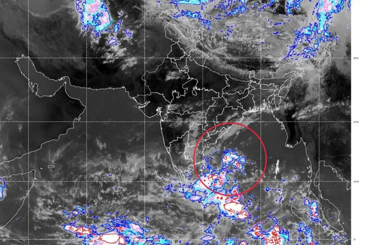
High-resolution cyclone arnab live satellite image bay of bengal feeds confirm convective banding rotating around the core. Advanced S-band Doppler radar tracking in Bhubaneswar calculates storm reflectivity and spiral feeder bands as the system tracks northwestward.
The name was contributed by Bangladesh under the unified tropical cyclone naming roster established by the World Meteorological Organization and ESCAP. In Bengali, the word translates directly to ocean, symbolizing the vast marine expanse that nurtured its cyclogenesis. Hourly bulletins are published directly by the IMD Meteorological Centre Bhubaneswar portal.
Projected Landfall Zone Between Bapatla & Visakhapatnam
Numerical weather prediction models agree on a landfall window around the forenoon of October 28, 2026. The core eyewall is projected to cross the shoreline between Bapatla and Visakhapatnam in northern Andhra Pradesh as a very severe cyclonic storm.
| Parameter | Current Meteorological Specification | Expected Landfall Value |
|---|---|---|
| System Classification | Severe Cyclonic Storm (intensifying) | Very Severe Cyclonic Storm |
| Sustained Core Winds | 90 to 100 km/h | 115 to 125 km/h |
| Peak Gust Velocity | Up to 115 km/h | Up to 140 km/h |
| Central Barometric Pressure | 988 hPa | 974 hPa |
| Present Forward Speed | 14 km/h | 12 to 16 km/h |
| Projected Landfall Corridor | West-central Bay of Bengal | Andhra Coast (Bapatla to Visakhapatnam) |
Official IMD Forecast Track & Chronological Timeline
The Cyclone Warning Division of the India Meteorological Department issued the observed and forecast storm track based on 1800 UTC (23:30 IST) of October 25, 2026, plotting the system coordinates at Latitude 15.3° N and Longitude 89.7° E over the east-central adjoining southeast Bay of Bengal.
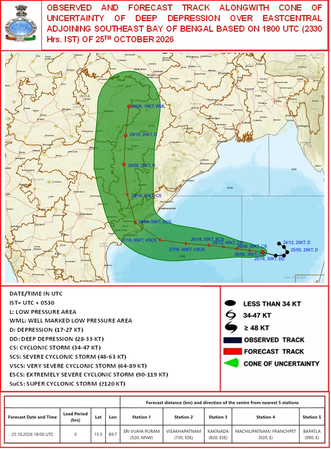
Official track map and cone of uncertainty issued by the India Meteorological Department (IMD) on October 25, 2026, tracking the intensification and forecast landfall of Cyclone Arnab across the Bay of Bengal.
Distance of Cyclone Center from Key Regional Coastal Stations
At the time of the 1800 UTC bulletin on October 25, 2026, the center of the deep depression was positioned at the following radial distances and bearings from key coastal stations:
| Station Name | Radial Distance from Center | Bearing / Direction |
|---|---|---|
| Sri Vijaya Puram (Port Blair) | 520 km | North-Northwest (NNW) |
| Visakhapatnam | 730 km | East-Southeast (ESE) |
| Kakinada | 820 km | East-Southeast (ESE) |
| Machilipatnam / Franchpet | 920 km | East (E) |
| Bapatla | 990 km | East (E) |
Chronological Storm Progression & Intensity Timeline
The official forecast track outlines the meteorological lifecycle of Cyclone Arnab from initial genesis through landfall and overland dissipation:
| Date & Observation Time | Stage Classification | Sustained Wind Speed | Movement & Trajectory Corridor |
|---|---|---|---|
| 24 Oct 2026, 17:30 IST (12:00 UTC) | Depression (D) | 25 knots (45 km/h) | Observed disturbance consolidating in Southeast Bay of Bengal |
| 25 Oct 2026, 05:30 IST (00:00 UTC) | Depression (D) | 25 knots (45 km/h) | West-northwestward drift across east-central waters |
| 25 Oct 2026, 23:30 IST (18:00 UTC) | Deep Depression (DD) | 30 knots (55 km/h) | Deep depression stage reached at 15.3°N, 89.7°E |
| 26 Oct 2026, 05:30 IST (00:00 UTC) | Cyclonic Storm (CS) | 35 knots (65 km/h) | Officially designated Cyclonic Storm Arnab |
| 26 Oct 2026, 11:30 IST (06:00 UTC) | Cyclonic Storm (CS) | 40 knots (75 km/h) | Forward track continuing west-northwestward |
| 26 Oct 2026, 17:30 IST (12:00 UTC) | Cyclonic Storm (CS) | 45 knots (83 km/h) | Rapid moisture feeding across central Bay of Bengal |
| 26 Oct 2026, 23:30 IST (18:00 UTC) | Severe Cyclonic Storm (SCS) | 55 knots (102 km/h) | System intensifies into a Severe Cyclonic Storm |
| 27 Oct 2026, 11:30 IST (06:00 UTC) | Very Severe Cyclonic Storm (VSCS) | 65 knots (120 km/h) | Core wind speeds reach Very Severe threshold |
| 27 Oct 2026, 23:30 IST (18:00 UTC) | Very Severe Cyclonic Storm (VSCS) | 65 knots (120 km/h) | Peak intensity maintained off the central Andhra coastline |
| 28 Oct 2026, 11:30 IST (06:00 UTC) | Severe Cyclonic Storm (SCS) | 55 knots (102 km/h) | Landfall crossing between Bapatla and Kakinada / Rajahmundry |
| 28 Oct 2026, 23:30 IST (18:00 UTC) | Cyclonic Storm (CS) | 35 knots (65 km/h) | Recurving northward overland past Telangana and interior AP |
| 29 Oct 2026, 11:30 IST (06:00 UTC) | Depression (D) | 25 knots (45 km/h) | Weakening near Jagdalpur / Bastar along the southern Odisha border |
| 29 Oct 2026, 23:30 IST (18:00 UTC) | Depression (D) | 20 knots (37 km/h) | System center passes northward across Chhattisgarh |
| 30 Oct 2026, 11:30 IST (06:00 UTC) | Well Marked Low Pressure Area (WML) | 15 knots (28 km/h) | Remnant low pressure dissipating over eastern Madhya Pradesh |
Why the Inland Recurvature Threatens Southern Odisha
A critical insight revealed by the IMD track chart is the system post-landfall direction. Rather than collapsing immediately upon striking coastal Andhra Pradesh on October 28, the storm curves due north across the Deccan plateau.
As the center passes near Rajahmundry and tracks through Jagdalpur in Bastar on October 29, the eastern quadrant of the cyclonic wind field sweeps across Malkangiri, Koraput, and Rayagada. These outer spiraling feeder bands push heavy moisture against the Eastern Ghats escarpment, producing prolonged orographic rainfall across southern Odisha river basins for up to 48 hours after landfall.
Even though the primary eye crosses south of the Odisha border, the cyclonic wind field extends more than 250 kilometers outward. For broad meteorological alert frameworks, consult our guide to live cyclone updates and coastal tracking alerts in Odisha to review color-coded public readiness stages.
Odisha District-Wise Weather Impact: Rainfall Forecast & Squall Alerts
The primary hazard facing Odisha from Cyclone Arnab is intense, continuous precipitation generated by outer feeder bands. Mountainous terrain in southern districts amplifies downpours through orographic uplift, creating rapid river swelling.
Southern Highland Districts: Malkangiri, Koraput & Rayagada
The interior southern highlands represent the most vulnerable topography for secondary disaster impact. Heavy tropical downpours falling over steep catchments drain rapidly into regional rivers like the Sabari, Sileru, Kolab, and Nagavali.
In the remote river basins of Malkangiri district, low-lying causeways near Motu and Kalimela are susceptible to submergence, which can isolate rural villages. District officials have stationed motorized rescue boats and heavy dewatering pumps along vulnerable riverbanks.
Neighboring highland plateaus in the highland plateau of Koraput district face flash flood warnings, particularly along ghat roads connecting Jeypore and Koraput town. Saturated soils on hillside cuts present localized landslide risks.
Further east along the hill slopes of Rayagada district, revenue inspectors monitor railway culverts and rural road bridges. Flash runoff from the Niyamgiri and Kasipur hills can surge into local streams within hours of persistent rain.
Coastal Red & Orange Alert Zones: Ganjam & Gajapati
Odisha’s southern coastal boundary directly borders Andhra Pradesh, placing it within immediate range of strong maritime squalls. District administrations have activated village cyclone shelters and alerted local medical facilities.
| District Name | IMD Alert Stage | Forecast Rainfall (24 Hours) | Key Local Hazards |
|---|---|---|---|
| Ganjam | Red Alert | 115 mm to 205 mm (Isolated >205 mm) | Coastal storm surge, sea wall erosion, urban waterlogging |
| Gajapati | Red Alert | 115 mm to 205 mm (Isolated >205 mm) | Hill slope landslides, flash floods in Mahendragiri valleys |
| Rayagada | Orange Alert | 70 mm to 115 mm | Nagavali river swelling, railway underpass flooding |
| Koraput | Orange Alert | 70 mm to 115 mm | Ghat road blockages, bridge runoff in Kolab basin |
| Malkangiri | Orange Alert | 70 mm to 115 mm | Low-lying causeway inundation, rural culvert overflow |
Coastal blocks across the coastal district of Ganjam face squally winds reaching 50 to 60 km/h, with occasional gusts touching 70 km/h. Saline embankments along coastal estuaries are closely guarded to prevent saltwater breach into agricultural paddies.
State Emergency Mobilization: ODRAF, Evacuations & School Closures
The Government of Odisha maintains a strict zero-casualty governance doctrine during extreme tropical weather events. The Special Relief Commissioner Odisha administration coordinates inter-departmental relief operations from the State Emergency Operation Centre in Bhubaneswar.
Precautionary Holidays for Educational Institutions
To ensure child safety and free up school buildings for emergency sheltering, district collectors exercised statutory powers to declare school holidays. All government, private, and aided schools, colleges, and Anganwadi centers in five southern districts remain closed on October 28 and 29.
Senior administrative ministers have been assigned to camp at district headquarters in Berhampur, Paralakhemundi, and Koraput. These officials supervise inter-agency coordination between revenue officers, block development officers, and medical teams.
Special care is directed toward vulnerable citizens living in thatched or kucha dwellings. Under health department guidelines, proactive pregnant women hospital evacuation procedures ensure expectant mothers reach equipped delivery wards days ahead of peak rainfall.
Deployment of Rescue Units & Cyclone Shelter Activation
Specialized search-and-rescue teams from the Odisha Disaster Rapid Action Force (ODRAF) coordinate with the National Disaster Management Authority across high-risk blocks. Equipped with tree-cutting saws, high-capacity diesel pumps, and satellite phones, these personnel stand ready for immediate deployment.
More than 800 stilted multipurpose cyclone shelters overseen by the Odisha State Disaster Management Authority have been unlocked, cleaned, and stocked with relief supplies. Each facility possesses dedicated solar backup power and independent drinking water supplies.
Community volunteers known as Cyclone Mitras coordinate with local sarpanches to manage voluntary evacuations before nightfall. Dry food rations, baby food packets, and oral rehydration salts are stored inside each shelter to sustain displaced families.
24x7 Emergency Helplines & Disaster Control Rooms
The state administration operates round-the-clock emergency desks to coordinate rescue, medical assistance, power restoration, and district relief operations:
| Agency / Public Utility | Contact Number | Operational Scope & Coverage |
|---|---|---|
| State Emergency Operation Centre (SEOC) | 0674-2534177 / 0674-2534176 | State-level disaster monitoring, Bhubaneswar |
| Universal Police, Fire & Ambulance | 112 (Toll-Free) | Statewide immediate emergency response |
| District Emergency Operations (DEOC) | 1077 (Toll-Free) | District Collectorate control in Ganjam, Gajapati, Koraput, Rayagada, Malkangiri |
| East Coast Railway Passenger Helpdesk | 139 / 0674-2303060 | Live train running status, regulation, and rescheduling |
| Power Disruption Emergency (TPSODL/TPCODL) | 1912 (Toll-Free) | Uprooted electrical poles, fallen live wires, substation outages |
| Odisha Disaster Rapid Action Force (ODRAF) | 0674-2539977 | Specialized search, swift-water rescue, and obstacle clearance |
Maritime Advisories: Port Warning Signals & Fishermen Prohibitions
Maritime operations face severe hazards as cyclonic swells propagate northward across the Bay of Bengal. Visual warning signals and strict administrative bans safeguard marine operators.
Distant Cautionary Signal 1 at Paradip, Dhamra & Gopalpur
Major commercial seaports along the Odisha coast hoisted Distant Cautionary Signal No. 1 following direct directives from the Cyclone Warning Division. This advisory notifies merchant vessels that a cyclonic storm has formed far out at sea.
At the deep-water harbor of Gopalpur, port authorities instructed cargo vessels at outer anchorages to take precautionary sea room. Tugs, pilot launches, and mooring equipment were secured against heavy swell action.
Similar protocols were initiated at Paradip Port in Jagatsinghpur and Dhamra Port in Bhadrak. Harbor masters maintain continuous VHF radio watches to broadcast nautical coordinates and wind vectors to passing merchant shipping.
Total Suspension of Marine Fishing Operations
The Department of Fisheries issued a total prohibition preventing fishermen from venturing into the sea. Coastal police and fisheries officers patrolled fish landing centers to enforce mandatory compliance.
[!WARNING] Trawlers, motorized boats, and traditional country crafts must remain securely berthed inside backwater jetties until the India Meteorological Department releases an all-clear bulletin. Navigating open sea channels during active storm warnings carries extreme life risk.
Fishermen who were already operating in deep offshore waters were contacted via distress alert transmitters and coastal radio stations. All vessels returned safely to designated fish landing quays before wind conditions deteriorated.
Travel Disruptions: Train Rescheduling, Road Routes & Beach Restrictions
Extreme weather advisories require adjustments for travelers moving across southern Odisha. Rail and highway networks enforce precautionary protocols to ensure transit security.
South Eastern & East Coast Railway Precautions
The East Coast Railway activated specialized disaster control desks at division headquarters in Khurda Road and Waltair. Patrolling squads inspect railway tracks, overhead electric wires, and track drainage systems across coastal sections.
To protect passengers during peak squall winds, train speeds are regulated below 60 km/h across vulnerable coastal stretches between Khurda Road, Palasa, and Visakhapatnam. Certain passenger and express trains operating along the Howrah-Chennai coastal corridor may experience rescheduling, regulation, or short-termination based on localized anemometer wind readings.
For passengers checking live train running status, East Coast Railway operates divisional emergency inquiry desks:
- Khurda Road Division Helpdesk: 0674-2490011 / 0674-2490012
- Waltair Division (Visakhapatnam) Helpdesk: 0891-2746330 / 0891-2746340
- Bhubaneswar Railway Station Emergency Desk: 0674-2303060
- Universal Railway Inquiry: Dial 139 or access the Indian Railways National Train Enquiry System (NTES) online.
Refreshment stalls and passenger waiting halls at major junction stations remain fully operational with emergency backup lighting and medical first-aid booths.
Highway Transit Hazards Along National Highway 16
National Highway 16 links Kolkata, Bhubaneswar, Berhampur, and Visakhapatnam, serving as the economic spine of the eastern coastline. Road transport agencies urge motorists to postpone non-essential highway travel between Ganjam and northern Andhra Pradesh.
Heavy crosswinds can destabilize high-sided commercial trucks and two-wheelers on elevated highway bridges. In addition, uprooted roadside trees present collision risks during nighttime travel.
District highway patrol teams remain stationed with tow trucks and crane units near known bottleneck points. Drivers encountering intense cloudbursts should pull safely off the highway onto elevated petrol pump forecourts until visibility improves.
Beach Bans in Puri, Gopalpur & Southern Coasts
Municipal authorities have closed seaside promenades to ensure public safety. High astronomical tides combined with cyclonic swell waves create dangerous surf along sandy beaches.
Lifeguards and local police have hoisted red warning flags along the heritage shoreline of Gopalpur beach, barring tourists from entering seawater. Boating and recreational water sports at the freshwater lagoon of Tampara lake remain suspended until sea conditions normalize.
Similar precautionary measures apply further north. While travelers inquire will cyclone arnab hit puri and bhubaneswar directly, current forecasts show the eyewall passing south, yet visitors traveling to coastal tourist destinations in Puri are prohibited from bathing at Swargadwar and the Blue Flag beach during squally weather alerts.
Comparative Analysis: Cyclone Arnab vs Previous Bay of Bengal Storms
Placing Cyclone Arnab within meteorological history illustrates how storm paths determine regional damage. While every cyclonic event is distinct, historical comparisons highlight Odisha’s refined operational resilience.
Comparing Arnab with Cyclone Dana & Cyclone Phailin
Cyclone Arnab shares seasonal timing with recent tropical systems but presents a contrasting geographical impact corridor. Cyclone Dana struck northern Odisha near Bhitarkanika when recorded in October 2024, focusing its wind field on Kendrapara and Bhadrak.
In contrast, Cyclone Phailin in October 2013 made direct landfall near Gopalpur as a Category 5 equivalent system, packing winds exceeding 220 km/h. Arnab tracks further south toward Andhra Pradesh, sparing southern Odisha from direct eyewall destruction while still delivering heavy peripheral rainfall.
| Tropical Storm | Month & Year | Primary Landfall Point | Peak Wind Speed | Core Impact in Odisha |
|---|---|---|---|---|
| Cyclone Phailin | October 2013 | Gopalpur, Ganjam | 220 km/h | Widespread coastal destruction; 1.15 million evacuated |
| Cyclone Titli | October 2018 | Palasa (Odisha-Andhra border) | 150 km/h | Devastating flash floods and hill landslides in Gajapati |
| Cyclone Dana | Recorded in October 2024 | Bhitarkanika / Dhamra | 110 km/h | Northern coastal storm surge; perfect zero-casualty outcome |
| Cyclone Arnab | Recorded in October 2026 | Bapatla / Visakhapatnam (Andhra) | 125 km/h | Southern highland rain alerts; school closures; rapid response |
Comprehensive historical storm records are cataloged in our chronological history of major cyclones in Odisha, detailing decades of institutional disaster preparedness.
Lessons from Cyclone Titli in Southern Odisha
The trajectory of Cyclone Arnab particularly recalls the operational lessons learned during Cyclone Titli in October 2018. During Titli, the cyclone weakened over land but stalled near the southern hills, dropping historic volumes of rain that triggered devastating valley landslides in Gajapati district.
Having recognized this vulnerability, state disaster managers now treat southern highland rainfall with the same urgency as coastal storm surges. Early deployment of earthmovers and prepositioning of food rations in remote hill villages reflect lessons learned directly from the Titli experience.
Emergency communication centers in the capital city of Bhubaneswar maintain satellite telemetry links with district control rooms, ensuring uninterrupted flow of ground data regardless of power disruptions.
Frequently Asked Questions About Cyclone Arnab in Odisha
What is the latest status of Cyclone Arnab in Odisha?
Cyclone Arnab is an active cyclonic storm over the west-central Bay of Bengal moving toward the northern Andhra Pradesh coastline. Southern Odisha districts face heavy to very heavy rainfall alerts and squally winds reaching 50 to 60 km/h.
When and where is Cyclone Arnab expected to make landfall?
Cyclone Arnab is forecast to cross the Andhra Pradesh coastline between Bapatla and Visakhapatnam around the forenoon of October 28, 2026. Maximum sustained winds during landfall are estimated at 115 to 125 km/h gusting to 140 km/h.
Which districts in Odisha are most affected by Cyclone Arnab?
The five southern districts of Ganjam, Gajapati, Rayagada, Koraput, and Malkangiri face the highest weather alerts due to intense rainfall and squally winds. Local administrations have issued warnings for localized flooding, river swelling, and potential hill slope landslides.
What does the name Arnab mean and who named it?
The name Arnab was contributed by Bangladesh under the international tropical cyclone naming roster overseen by the World Meteorological Organization. In Bengali, the word translates directly to ocean, honoring the marine environment where the storm formed.
Are schools and colleges closed in Odisha due to Cyclone Arnab?
Yes, the Odisha government ordered the precautionary closure of all schools, colleges, and Anganwadi centers in five southern districts on October 28 and 29, 2026. The measure protects students from heavy rain hazards and frees up institutional buildings for emergency shelters.
What are the helpline numbers during Cyclone Arnab in Odisha?
Citizens can dial 112 for universal emergency assistance including police, ambulance, and fire services, or call District Emergency Operation Centres directly at 1077. The State Emergency Operation Centre in Bhubaneswar is operational 24x7 at 0674-2534177.
How fast are the wind speeds expected from Cyclone Arnab?
Peak core winds near the cyclone center are projected to reach 115 to 125 km/h with gusts touching 140 km/h during landfall in Andhra Pradesh. Coastal and southern Odisha districts are forecast to experience squally winds of 50 to 60 km/h gusting to 70 km/h.
Will Cyclone Arnab hit Puri and Bhubaneswar directly?
Current meteorological tracking from the India Meteorological Department indicates that Cyclone Arnab will not make direct landfall in Puri or Bhubaneswar. The central eyewall is projected to cross the coastline south of Odisha between Bapatla and Visakhapatnam. However, central coastal districts including Puri, Khurda, and Cuttack will experience overcast skies, gusty winds reaching 40 to 50 km/h, and sporadic showers from outer cloud bands. Bathers and tourists in Puri are barred from entering the sea while red warning flags remain hoisted.
Are trains cancelled or delayed in Odisha due to Cyclone Arnab?
East Coast Railway has instituted precautionary speed restrictions below 60 km/h for trains operating across coastal routes between Khurda Road, Palasa, and Visakhapatnam. While short-distance local passenger trains in border sectors may experience regulation or rescheduling, long-distance express services along the Howrah-Chennai trunk corridor remain operational under intensified track monitoring. Passengers should check real-time updates via the 139 helpline or the NTES mobile application before journeying.