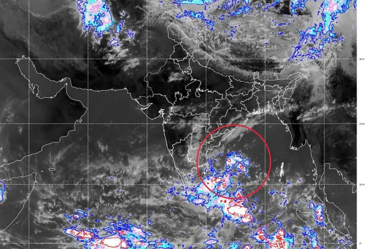
Cyclone Update in Odisha: Live Tracking, Alerts & Safety Guide
Track the latest cyclone update in Odisha with live IMD weather alerts, Bay of Bengal tracking, port signals, emergency helplines, and coastal safety rules.
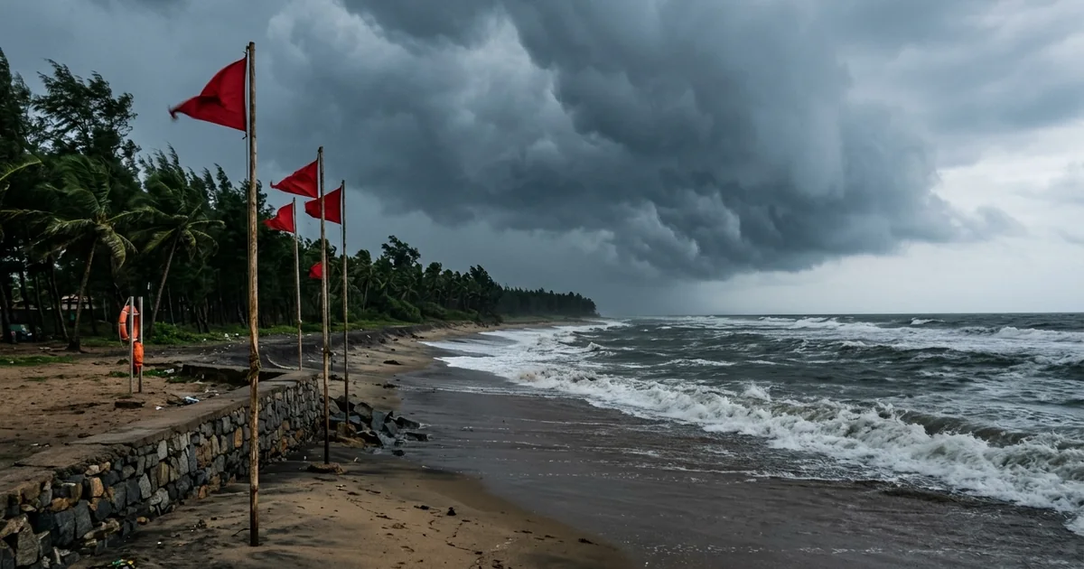
Monitoring an active cyclone update in odisha is vital for coastal residents, fishers, and travelers moving through the eastern seaboard. With a 480-kilometer coastline facing the Bay of Bengal, the state routinely tracks tropical depressions from initial cyclogenesis to eventual coastal landfall.
Key Takeaways
- The India Meteorological Department (IMD) issues real-time tropical cyclone tracking via Doppler weather radar networks and four-stage color alerts.
- Southern districts including Ganjam, Gajapati, Rayagada, Koraput, and Malkangiri frequently face heavy rainfall and squally winds during Bay of Bengal storm systems.
- Standardized port warning signals from Signal 1 to Signal 11 inform merchant shipping, port authorities, and local mechanized fishing vessels of sea conditions.
- Odisha operates over 800 stilted multipurpose cyclone shelters and automated Early Warning Dissemination System (EWDS) siren towers for emergency evacuations.
- Centralized emergency response is reachable at 112, District Emergency Operation Centres at 1077, and electricity disruption assistance at 1912.
Advanced meteorological systems allow coastal communities to prepare days before cyclonic wind fields approach mainland beaches and river deltas.
Odisha Cyclone Status at a Glance: Current Weather & Coastal Alerts
A real-time odisha cyclone update requires understanding both the central low-pressure trajectory over the Bay of Bengal and the peripheral cloud bands delivering localized rainfall. Tropical storms developing in the central or southern Bay of Bengal gather energy from sea surface temperatures exceeding 28 degrees Celsius before steering northwestward.
Bay of Bengal Storm Trajectory & Intensification
The India Meteorological Department tracks cyclonic disturbances through sequential classifications, starting from a low-pressure area and depression to a severe cyclonic storm. As deep depressions gather moisture and rotate around a consolidated low-pressure center, coastal wind fields accelerate across the maritime boundary.
During active systems like Cyclone Arnab, named by Bangladesh to mean ocean, the storm intensifies over the central Bay of Bengal before approaching landfall. Projected to cross the Andhra coast between Bapatla and Visakhapatnam with wind speeds of 115 to 125 km/h, its peripheral rain bands trigger severe weather across southern Odisha. Readers tracking storm mechanics can explore our dedicated Cyclone Arnab landfall and tracking guide for technical meteorological data.
Southern & Coastal Districts Under Active Warning
Regional emergency administrations categorize weather impact by district vulnerability. Southern highland and coastal districts encounter distinct risks ranging from flash floods in hilly river valleys to marine inundation along exposed sea walls.
| District Belt | Key Districts Included | Primary Storm Hazards | Administrative Action Level |
|---|---|---|---|
| South Coastal Belt | Ganjam, Gajapati | Storm surge, beach erosion, squall winds | Orange to Red Alert; shelter activation |
| South Highland Belt | Rayagada, Koraput, Malkangiri | Flash floods, valley runoff, hill landslides | Heavy downpour alert; school closures |
| Central Delta Belt | Puri, Jagatsinghpur, Kendrapara | Tidal ingress, waterlogging, river swelling | Coastal monitoring; boat venture ban |
| North Coastal Belt | Bhadrak, Balasore | Saline embankments, estuary high tides | Distant cautionary alert; port signals |
The North Coastal Belt encompassing Chandipur beach in Balasore and the Dhamra estuary faces saline inundation during equinoctial high tides. During intense storms, southern collectors order school holidays across Ganjam, Gajapati, Rayagada, Koraput, and Malkangiri. More than 300 disaster response personnel stand ready to clear road corridors and manage localized flooding.
IMD Color-Coded Alert Stages & Port Storm Warning Signals Explained
Understanding the official imd bhubaneswar cyclone warning protocol prevents panic and ensures appropriate precautions. The India Meteorological Department communicates public risk through a standardized four-color alert system while issuing numeric port warning signals for maritime operators.
Decoding the 4-Stage IMD Weather Warning Colors
The color code represents both the probability of severe weather and the severity of expected disruptions. Each stage demands specific readiness actions from citizens, transport agencies, and local district authorities.
- Green (No Warning / Normal Routine): Clear weather conditions prevail across coastal and interior districts. No special emergency action is needed by municipal bodies or travelers.
- Yellow (Watch / Be Updated): Severe weather is possible over the next 48 hours. Citizens should verify travel itineraries, monitor weather bulletins, and secure vulnerable rooftop items.
- Orange (Alert / Be Prepared): Damaging weather is highly probable within 24 to 48 hours. Transport operations face potential delays, coastal boats are recalled to jetties, and district shelters open.
- Red (Warning / Take Immediate Action): Dangerous, high-impact weather is imminent or occurring within 24 hours. Compulsory evacuations begin from low-lying huts to pucca shelters, and all non-essential road travel is restricted.
Understanding Indian Port Warning Signals 1 Through 11
Indian commercial harbors and fishing terminals hoist numbered visual signals consisting of geometric shapes by day and colored lanterns by night. These cyclone port warning signals inform ships at anchor and vessels preparing to exit open sea channels.
| Signal Number | Technical Signal Name | Weather Meaning at Harbor | Marine & Vessel Action Directive |
|---|---|---|---|
| Signal 1 | Distant Cautionary | Low pressure or depression far at sea | Harbor unaffected; outgoing vessels alerted |
| Signal 2 | Distant Warning | Cyclonic storm formed far in deep waters | Ships leaving port may face rough open seas |
| Signal 3 | Local Cautionary | Port threatened by squally coastal winds | Port operations continue with heightened caution |
| Signal 4 | Local Warning | Storm approaching; port may experience impact | Small coastal crafts must stay inside harbors |
| Signal 5 | Local Danger (Left) | Moderate cyclone striking to east/left of port | Ships move to safe anchorages; cargo pauses |
| Signal 6 | Local Danger (Right) | Moderate cyclone striking to west/right of port | Berthing suspended; outer harbor clearance |
| Signal 7 | Local Danger (Direct) | Moderate cyclone striking directly over port | Harbor operations shut down; vessels secured |
| Signal 8 | Great Danger (Left) | Severe cyclone striking to east/left of port | Port facilities face severe structural risk |
| Signal 9 | Great Danger (Right) | Severe cyclone striking to west/right of port | Complete shutdown; harbor evacuation underway |
| Signal 10 | Great Danger (Direct) | Severe cyclone striking directly over port | Catastrophic winds and storm surge expected |
| Signal 11 | Communication Failure | Local contact with warning center broken | Port officer assumes extreme cyclone emergency |
When major commercial terminals at Paradip, Dhamra, and Gopalpur hoist Distant Cautionary Signal 1, port captains verify ship mooring cables and broadcast regular nautical advisories across marine VHF channels.
Live Tracking Portals & Early Warning Radar Systems in Odisha
Reliable meteorological data is essential when tracking tropical storm systems. The state relies on multi-layered radar infrastructure, geostationary satellites, and automated coastal telemetry stations to calculate storm coordinates and projected landfall corridors.
Official IMD Doppler Weather Radar & Satellite Imagery
The Meteorological Centre in the capital city of Bhubaneswar operates an advanced S-band Doppler weather radar that monitors atmospheric reflectivity, hydrometeor velocity, and storm structure within a 500-kilometer radius. Radar observations supplement high-resolution INSAT-3D and INSAT-3DR satellite imagery, capturing spiral rain bands as they rotate across the northwestern Bay of Bengal.
Travelers and residents can access verified live tracking data directly through the IMD Meteorological Centre Bhubaneswar portal. The portal provides hourly radar animations, district-level nowcasts updated every three hours, and coastal wind speed vectors.
[!TIP] Rely exclusively on official meteorological bulletins from IMD Bhubaneswar or OSDMA rather than unverified social media storm tracks. Automated weather apps often use raw numerical models that display shifting landfall predictions without expert meteorologist synthesis.
Early Warning Dissemination System (EWDS) Alert Towers
Odisha was the first state in India to commission a dedicated Early Warning Dissemination System along its coastline. The system links State and District Emergency Operation Centres directly to 122 siren alert towers erected within 1.5 kilometers of high-tide coastlines.
During an impending landfall, emergency officers can activate tower sirens with a single command from Bhubaneswar. The towers broadcast loud siren alerts followed by clear voice warnings in Odia, alerting coastal villagers, salt-pan workers, and beachgoers before telecommunication towers suffer wind damage.
Emergency Helplines, District Control Rooms & OSDMA Shelter Network
Institutional coordination ensures that early storm detection translates into immediate community safety. The state emergency apparatus operates through round-the-clock control rooms, specialized rescue teams, and reinforced shelter facilities constructed along coastal river plains.
State Emergency Operation Centre & District 1077 Hotlines
During severe weather warnings, the Special Relief Commissioner Odisha administration coordinates inter-departmental relief operations from the State Emergency Operation Centre in Bhubaneswar. Dedicated control rooms operate across all thirty districts, providing localized assistance and directing field teams to areas experiencing waterlogging or fallen trees.
| Emergency Agency | Contact Channel | Operational Hours | Core Service Function |
|---|---|---|---|
| Centralized Emergency Response | 112 | 24 Hours / 7 Days | Universal dispatch for police, fire, and ambulance |
| State Emergency Operation Centre | 0674-2534177 | 24 Hours / 7 Days | State disaster command and inter-district logistics |
| District Emergency Operation Centre | 1077 | 24 Hours / 7 Days | Local district control room in every district office |
| Odisha Fire & Emergency Services | 101 | 24 Hours / 7 Days | Urban dewatering, tree clearing, and water rescues |
| Power Utility Emergency Helpline | 1912 | 24 Hours / 7 Days | Reporting snapped overhead lines and power cuts |
| Emergency Ambulance Network | 108 | 24 Hours / 7 Days | Patient transport to medical colleges and hospitals |
If landline networks experience congestion during extreme weather, citizens can contact the universal emergency number 112 from any mobile device, which routes distress calls to the nearest available emergency responder. Emergency trauma centres among the top healthcare facilities in Bhubaneswar maintain auxiliary generators and critical medicine reserves during weather alerts.
Multipurpose Cyclone Shelters & Zero Casualty Evacuation
The Odisha State Disaster Management Authority oversees more than 800 stilted multipurpose cyclone shelters located across coastal belts. Engineered to withstand wind speeds exceeding 250 km/h and high tidal surges, these reinforced concrete buildings stand on elevated pillars above historical flood levels.
Each shelter features separate dormitory halls for women, men, and children, sanitary washrooms, backup solar power, and deep borehole water pumps. In peace times, these buildings serve as schools and community halls, remaining integrated into village life.
Rail passenger coordination ensures long-distance routes like the Puri to Howrah Vande Bharat Express operate under regulated speed controls before coastal wind speeds reach critical thresholds.
Tourist Safety Protocols & Coastal Travel Precautions
A tropical storm warning requires travelers visiting coastal Odisha to adjust their sightseeing plans and observe municipal safety guidelines. Beach destinations and coastal transit corridors require prompt, disciplined precautions when warning flags are hoisted.
Beach Safety in Puri, Gopalpur & Chandipur
Ocean conditions change rapidly as cyclonic systems approach coastal waters. Long-period swell waves, unpredictable rip currents, and high tidal surges make swimming dangerous even when onshore rain appears moderate.
Visitors exploring coastal attractions in Puri must observe beach closure notices and lifeguard instructions along the coast. Red warning flags hoisted along the shoreline of Blue Flag certified Puri beach indicate that entering seawater is strictly prohibited by district police.
Similar maritime restrictions apply to southern beaches. Travelers visiting the Gopalpur beach coastline in Ganjam or scenic boat launches around Tampara lake near Chatrapur should avoid shoreline promenades during squally weather.
[!WARNING] Never stand on rocky sea walls, concrete groynes, or beach piers to photograph rough surf during a cyclonic weather alert. Sudden rogue waves generated by distant tropical storms can sweep spectators off coastal barriers into deep waters.
Transit Contingency: Highways, Regional Roads & Flying Precautions
Severe cyclonic systems can disrupt highway and air transportation across eastern India. Understanding transport contingencies helps travelers make safe journey decisions before adverse weather arrives.
- Air Travel Connections: Biju Patnaik International Airport features modern crosswind monitoring and navigational systems. During high-intensity gales, commercial airlines may adjust schedules, reroute inbound flights, or pause ramp handling until wind speeds subside below safe operating limits.
- Highway Road Transit: National Highway 16 serves as the primary coastal transport artery connecting Balasore, Cuttack, Bhubaneswar, Khordha, and Berhampur. Heavy rain can cause localized waterlogging near low underpasses, while falling highway avenue trees present collision hazards for long-distance road trips.
Essential Cyclone Emergency Survival Checklist
Travelers staying in hotels, guesthouses, or homestays during an active cyclonic alert should compile an emergency kit before conditions worsen. Modern hotel buildings in urban hubs generally feature backup diesel power, but localized outages can temporarily interrupt public utilities.
| Kit Item Category | Specific Items to Pack | Practical Traveler Purpose |
|---|---|---|
| Emergency Power | 20,000 mAh power bank, charging cables | Maintain mobile phone charge during power restoration |
| Clean Hydration | 4 to 5 liters of sealed bottled drinking water | Safeguard against municipal water supply interruptions |
| Dry Food Supplies | Biscuits, roasted nuts, chuda (flattened rice), jaggery | Non-perishable nourishment requiring no heating |
| Illumination Tools | LED flashlight, spare batteries, headlamp | Safely navigate hotel rooms during nocturnal outages |
| Personal Medical | Prescription medicines, ORS sachets, antiseptic wipes | Address routine health needs and minor cuts |
| Identity & Documents | Passport, Aadhaar card, tickets inside ziplock pouches | Protect sensitive identity cards from moisture damage |
| Cash Reserves | Small currency notes (₹100, ₹200, ₹500) | Complete transactions if digital payment networks pause |
Odisha Cyclone Vulnerability: Geography, History & Climate Patterns
Odisha’s geographic location along the northwestern curve of the Bay of Bengal makes it an epicenter of North Indian Ocean cyclonic activity. Examining historical weather patterns highlights how community preparedness transformed vulnerability into international disaster resilience.
Pre-Monsoon vs Post-Monsoon Cyclone Windows
Tropical cyclogenesis in the northern Indian Ocean follows a distinct bimodal seasonal pattern dictated by sea surface temperatures and monsoon circulation.
- Pre-Monsoon Season (April to May): Solar heating rapidly warms the upper ocean layers, generating intense localized tropical storms. While pre-monsoon systems are less frequent, they can intensify rapidly and make landfall as severe cyclones, such as Cyclone Fani in May 2019.
- Post-Monsoon Season (October to December): The withdrawal of the southwest monsoon creates low vertical wind shear across the Bay of Bengal, enabling tropical depressions to organize into large cyclonic systems. Statistically, post-monsoon storms account for the majority of intense landfalls along the eastern coastline.
Coastal topography also determines how weather systems interact with the land. Extensive natural mangrove barriers, such as the mangrove eco-buffers of Bhitarkanika National Park, absorb tidal surges and reduce wave energy before winds reach inland hamlets.
How Odisha Evolved from 1999 to Modern Storm Resilience
The devastating Super Cyclone of October 1999 fundamentally altered disaster management across India. The tragic loss of life led to the formation of OSDMA and a complete re-engineering of state emergency protocols.
Over the following decades, the state administration moved from reactive rescue missions to proactive zero-casualty evacuations. In the recorded history of major cyclones in Odisha, modern storms like Phailin (2013), Yaas (2021), and Dana (2024) saw hundreds of thousands of citizens evacuated within forty-eight hours, resulting in minimal casualties.
Specialized search-and-rescue teams from the Odisha Disaster Rapid Action Force (ODRAF) and the National Disaster Response Force (NDRF) are pre-positioned in vulnerable coastal blocks prior to landfall. Equipped with power chain saws, inflatable boats, and mobile communication equipment, these teams clear blocked highways and restore vital utility connections within hours of storm passage.
Frequently Asked Questions About Cyclones in Odisha
What is the current cyclone update for Odisha?
Tropical disturbances over the Bay of Bengal are tracked continuously by the India Meteorological Department through coastal radar systems and satellite updates. Southern and coastal districts receive specialized district weather bulletins whenever squally winds and heavy downpours threaten coastal belts.
Which districts in Odisha are on high alert during a Bay of Bengal cyclone?
Coastal and southern districts including Ganjam, Gajapati, Rayagada, Koraput, Malkangiri, Puri, Jagatsinghpur, Kendrapara, Bhadrak, and Balasore frequently receive priority alerts. The exact alert status depends on the storm’s forecast trajectory, central pressure, and distance from the coastline.
How can travelers track live cyclone updates in Odisha?
Travelers can monitor official live tracking bulletins directly on the India Meteorological Department Bhubaneswar portal and the Odisha State Disaster Management Authority website. Official district collectorate announcements on verified channels provide localized safety advisories and transport guidance.
What is the difference between Yellow, Orange, and Red cyclone alerts?
A Yellow alert serves as an informational watch to monitor weather conditions, while an Orange alert advises residents to prepare for severe disruptions. A Red alert represents the highest warning level, requiring immediate emergency actions and compulsory evacuations from vulnerable areas.
What emergency helpline numbers should residents and tourists call during a cyclone in Odisha?
Citizens can dial centralized emergency response at 112 for police, fire, or ambulance assistance, or contact District Emergency Operation Centres at 1077. The State Emergency Operation Centre in Bhubaneswar is reachable at 0674-2534177, and electricity disruption complaints can be reported to 1912.
Is it safe to visit Puri and Gopalpur beaches during a cyclone warning?
Entering the ocean or walking along open shorelines is strictly prohibited during cyclonic weather alerts due to heavy surf and dangerous storm surges. Visitors should stay inside reinforced hotel buildings and follow lifeguard directives whenever warning flags are hoisted at local beaches.
What should tourists do if stranded in Odisha during a cyclonic storm?
Stranded travelers should remain inside concrete accommodations with backup power, charge all essential electronic devices, and stock bottled water and dry food. Coordinate travel changes through official railway or airline helplines before leaving your hotel room.