Sambalpur District: Hirakud Dam, Samaleswari Temple, Silk & Guide
Discover Sambalpur district in Odisha. Explore Hirakud Dam, Maa Samaleswari Temple, Sambalpuri handloom sarees, Huma leaning temple, and travel logistics.
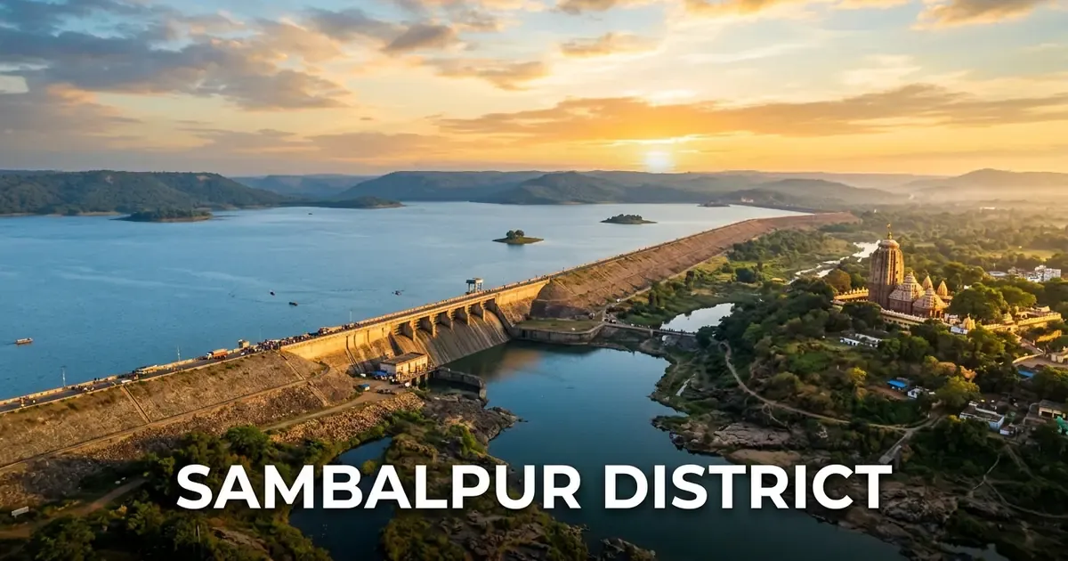
Sambalpur district stands as the indisputable cultural, educational, and commercial capital of Western Odisha. Located along the middle basin of the majestic Mahanadi River, the district blends monumental post-independence engineering achievements with celebrated goddess worship, world-renowned handloom textile artistry, and an enduring legacy of anti-colonial resistance.
From the monumental expanse of the Hirakud Dam, celebrated as the world’s longest earthen dam, to the riverside sanctum of Maa Samaleswari where millions seek blessings during the sacred agrarian festival of Nuakhai, Sambalpur preserves an authentic regional identity rooted in centuries of pride and devotion.
Today, Sambalpur functions as the administrative headquarters of the Northern Revenue Division, leading Western Odisha into a dynamic era of industrial manufacturing, higher academic excellence, and eco-tourism.
Key Takeaways
- Sambalpur district covers 6,657 square kilometers across three subdivisions, nine community development blocks, and nine tehsils.
- The district recorded a population of 1,041,099 in Census 2011, with a literacy rate of 76.22 percent and a population density of 156 persons per square kilometer.
- Hirakud Dam across the Mahanadi River is the longest earthen dam in the world, spanning 25.8 kilometers across main dykes and creating Asia’s largest artificial reservoir.
- Shree Shree Maa Samaleswari Temple on the bank of the Mahanadi serves as the supreme spiritual guardian of Western Odisha.
- Sambalpur is globally celebrated for its GI-tagged Sambalpuri Ikat handloom silk and cotton textiles, woven using traditional tie-and-dye techniques.
Introduction to Sambalpur: The Cultural & Industrial Metropolis of Western Odisha
Sambalpur district is situated in the western quadrant of Odisha, positioned between 20°40’ N to 22°11’ N latitude and 83°39’ E to 84°45’ E longitude. The district is bounded by Jharsuguda and Sundargarh districts to the north, Bargarh district to the west, Subarnapur and Balangir districts to the south, and Deogarh and Angul districts to the east. Travelers interested in the western agricultural belt and the famous open-air theater of Dhanu Yatra can explore our comprehensive Bargarh district guide.
Geographically, Sambalpur spans 6,657 square kilometers, representing 4.28 percent of Odisha’s total land area. The district serves as the seat of the Revenue Divisional Commissioner (RDC) for the Northern Division, overseeing administrative functions across ten western and northern districts.
The urban core forms a conurbation comprising Sambalpur city, the university town of Burla, and the industrial township of Hirakud, unified under the Sambalpur Municipal Corporation.
| Geographic Metric | Canonical Statistic | Regional Context |
|---|---|---|
| Total Geographical Area | 6,657 sq km | 4.28% of Odisha’s total territory |
| District Headquarters | Sambalpur City | Historic river port and administrative center |
| Revenue Division | Northern Division | Regional RDC headquarters located in Sambalpur |
| Geographic Coordinates | 20°40’ N – 22°11’ N, 83°39’ E – 84°45’ E | Middle Mahanadi basin and Barapahad hills |
| Average Elevation | 135 meters (443 feet) above sea level | River valley flanked by forested ridges |
| Forest Cover | 3,248 sq km | Nearly 48.8% of district land area |
| Motor Vehicle Registration (RTO) | OD-15 | Regional Transport Office, Sambalpur |
The climate of Sambalpur is tropical dry sub-humid. Summers are hot and dry from March to June, with daytime mercury frequently crossing 42°C. The monsoon season delivers an annual average of 1,527 millimeters of rain between June and September, transforming the river plains into fertile agricultural zones. Winters from November to February are pleasantly cool and dry, with temperatures averaging 12°C to 26°C.
Official district notices and public records are cataloged on the Sambalpur District Administration Official Portal.
Geographical Landscape, Mahanadi Basin & Natural Ecology
The topography of Sambalpur district is defined by the mighty Mahanadi River, which cuts through the central landscape from northwest to southeast. The river enters the district above Hirakud, widens into the vast artificial reservoir, and continues past Sambalpur city before flowing southward through rocky gorges toward Sonepur.
The terrain features fertile alluvial river plains flanked by undulating plateaus and rugged hill ranges. The prominent Barapahad Range stretches along the western and southwestern margins, rising to elevations exceeding six hundred meters and forming a natural boundary with Bargarh district.
Key rivers and hydrological networks include:
- Mahanadi River: The primary waterway of Odisha, providing irrigation, municipal water supply, hydroelectricity, and fisheries.
- Ib River: Major left-bank tributary that joins the Mahanadi reservoir from the north, draining fertile northern tracts.
- Bheden River: Tributary flowing through southern blocks into the Mahanadi basin.
- Malkhar River: Mountain stream originating in the Bamra hills, feeding local rural agriculture.
The district possesses dense forest cover spanning nearly 48.8 percent of its geographical surface, categorized under Northern Dry Mixed Deciduous and Tropical Moist Deciduous forest types. The dominant timber species include sal (Shorea robusta), teak, bija, asan, and bamboo.
These forested tracts shelter rich wildlife populations, including leopards, sloth bears, Indian bisons (gaur), spotted deer, wild boars, and diverse avifauna. The buffer forests of the Debrigarh Wildlife Sanctuary border the western waters of the Hirakud reservoir, providing an exceptional sanctuary for wildlife and eco-tourism.
Historical Evolution: From Vajrayana Roots to Veer Surendra Sai’s Revolt
Sambalpur possesses a distinguished historical lineage dating back to early classical antiquity, functioning as a crossroads of ancient diamond trade, Tantric philosophy, and armed anti-colonial defiance.
In ancient times, Greek geographer Ptolemy referred to the region as Sambalaka, situated on the banks of the river Manada (Mahanadi), celebrated throughout the Roman Empire for high-quality diamonds gathered from riverbed sands.
During the 8th century CE, Sambalpur emerged as a prominent cradle of Vajrayana Buddhism (Tantric Buddhism). King Indrabhuti of Sambhala ruled from this region and composed the foundational Buddhist philosophical treatise Jnanasiddhi, while his sister Lakshminkara propagated the Sahajayana school of Buddhist thought.
In the mid-16th century, King Balaram Deva founded the independent Chauhan dynasty of Sambalpur in 1570 CE. The Chauhan monarchs built formidable stone fortifications, established the worship of Goddess Samaleswari, and patronized regional literature and handloom weaving for nearly three centuries.
Following the death of Maharaja Sai without a male heir in 1827, the British East India Company intervened in the succession, sparking fierce regional resistance.
The resistance was spearheaded by the legendary freedom fighter Veer Surendra Sai, a direct descendant of the Chauhan royal family born at Khinda near Sambalpur. Surendra Sai rallied local tribal Gond and Binjhal chieftains, waging an armed guerrilla struggle against British colonial garrisons from the rugged caves and ravines of the Barapahad hills.
Captured and sentenced to life imprisonment in 1840, Surendra Sai was freed during the 1857 Mutiny by revolutionary sepoys in Hazaribagh. He returned to Sambalpur to lead an unbroken armed rebellion for another seven years until his betrayal and recapture in 1864. He passed away as an unyielding political prisoner at Asirgarh Fort in 1884, celebrated across India as an early hero of anti-colonial resistance.
In 1905, Sambalpur was transferred from the Central Provinces back to the Odisha Division of Bengal Presidency following the persistent agitation of local intellectuals who successfully preserved the Odia language as the official medium of governance and education.
Administrative Framework: Subdivisions, Blocks, Tehsils & Constituencies
Sambalpur district operates under a systematic administrative hierarchy designed to coordinate dense urban centers alongside extensive rural and tribal blocks. The executive leadership is headed by the Collector and District Magistrate stationed at Sambalpur city.
The district is divided into three administrative subdivisions:
- Sambalpur (Sadar) Subdivision: Administering the municipal corporation, urban IT and medical institutions, and surrounding agricultural panchayats.
- Kuchinda Subdivision: Encompassing the northern plateau, tribal development areas, and rich forest belts.
- Rairakhol Subdivision: Covering the eastern forested basins, historical estates, and agrarian valleys along the border of Angul.
The district contains nine Community Development (CD) blocks delivering primary health, education, and rural development programs across 138 Gram Panchayats.
| Block Name | Headquarters | Tehsils Included | Strategic Geographic & Economic Focus |
|---|---|---|---|
| Dhankauda | Dhankauda | Sambalpur | Peri-urban development, vegetable farming, dairy clusters |
| Maneswar | Maneswar | Maneswar | Religious pilgrimage, traditional brass craft, paddy farming |
| Jujomura | Jujomura | Sambalpur | Forest buffer agriculture, lac collection, rural schooling |
| Rengali | Rengali | Rengali | Heavy industrial plants, steel processing, thermal power |
| Kuchinda | Kuchinda | Kuchinda | Tribal welfare, dry chilli wholesale trading, timber processing |
| Bamra | Bamra | Bamra | Forestry reserves, minor forest produce, rail junction transit |
| Jamankira | Jamankira | Jamankira | Watershed conservation, horticulture, cashew plantations |
| Rairakhol | Rairakhol | Rairakhol | Ancient royal heritage, agricultural trade, handloom weaving |
| Naktideul | Naktideul | Naktideul | Deep forest buffer, medicinal plants, rural infrastructure |
Urban civic services are administered through three dedicated Urban Local Bodies (ULBs):
- Sambalpur Municipal Corporation (SMC): Covering the unified metropolitan region of Sambalpur, Burla, and Hirakud.
- Kuchinda NAC: Governing the commercial center of the northern tribal subdivision.
- Rairakhol NAC: Administering the historic transit town along the national highway.
In the legislative sphere, Sambalpur district elects four Members to the Odisha Legislative Assembly (MLAs):
- AC-15 Kuchinda (ST): Reserved for Scheduled Tribes, covering Kuchinda and Bamra blocks.
- AC-16 Rengali (SC): Reserved for Scheduled Castes, encompassing Rengali industrial zones and Dhankauda.
- AC-17 Sambalpur: The urban constituency covering Sambalpur city and municipal corporation wards.
- AC-18 Rairakhol: Encompassing the rural and forested communities of Rairakhol, Jujomura, and Naktideul blocks.
For national parliamentary elections, the entire district anchors the Sambalpur Parliamentary Constituency (PC-3) in the Lok Sabha.
Demographic Profile & Human Capital: Census 2011 Analysis
According to the 2011 Census of India, Sambalpur district recorded a total population of 1,041,099 residents, reflecting a balanced demographic profile across urban and rural sectors.
The population distribution counted 526,877 males and 514,222 females, yielding a favorable sex ratio of 976 females per 1,000 males. This metric outperforms the national average, demonstrating strong gender balance across Western Odisha communities.
With an area of 6,657 square kilometers, Sambalpur has a moderate population density of 156 persons per square kilometer, which is considerably lower than the coastal plain averages due to vast protected forests and hill tracts.
| Demographic Parameter | Census 2011 Metric | Regional Significance |
|---|---|---|
| Total Population | 1,041,099 | Major population anchor of Western Odisha |
| Male Population | 526,877 | 50.61% of total residents |
| Female Population | 514,222 | 49.39% of total residents |
| Sex Ratio | 976 females / 1,000 males | Significantly higher than the national baseline |
| Population Density | 156 persons / sq km | Moderate density due to extensive forest cover |
| Literacy Rate | 76.22% | Well above state and national literacy baselines |
| Male Literacy | 84.35% | High vocational, technical, and professional baseline |
| Female Literacy | 67.84% | Growing rapidly across rural schooling programs |
| Urban Population Share | 29.67% | Anchored by Sambalpur-Burla-Hirakud urban corridor |
| Rural Population Share | 70.33% | Distributed across 1,237 inhabited villages |
Human capital development is one of Sambalpur’s distinct strengths. The district recorded an overall literacy rate of 76.22 percent in Census 2011. Male literacy reached 84.35 percent, while female literacy stood at 67.84 percent.
The district’s urbanization rate stands at 29.67 percent, which is among the highest in Western Odisha, driven by the expanding industrial, healthcare, and university institutions of Sambalpur, Burla, and Hirakud.
The social composition includes a substantial tribal population. Scheduled Tribes (ST) account for 34.5 percent of the total population, represented by communities such as Gond, Binjhal, Kisan, Munda, and Oraon. Scheduled Castes (SC) account for 18.5 percent, concentrated largely in agricultural and artisan communities.
Engineering Marvel: Hirakud Dam & the Great Reservoir
Located fifteen kilometers north of Sambalpur city, Hirakud Dam stands as one of modern India’s most monumental civil engineering achievements. Built across the mighty Mahanadi River between 1948 and 1957, it was the first major multipurpose river valley project undertaken by independent India, dedicated to the nation by Prime Minister Jawaharlal Nehru on January 13, 1957.
Hirakud Dam holds the world record as the longest earthen dam ever constructed. The main masonry and concrete dam extends 4.8 kilometers, while massive earthen dykes flanking the reservoir bring the total dam length to an astonishing 25.8 kilometers.
The dam forms Asia’s largest artificial reservoir, impounding a water spread area of 743 square kilometers with a shoreline perimeter exceeding 640 kilometers.
Key engineering and visitor highlights of the Hirakud complex include:
- Gandhi Minar: A soaring watchtower perched on the revolving crest of the northern hillock at Burla, offering panoramic views of the vast blue reservoir and lush hill ridges.
- Nehru Minar: A companion observation tower standing on the southern dyke at Hirakud, providing close-up views of the monumental spillway gates and downstream discharge channels.
- Hydroelectric Power Generation: Operates dual powerhouses at Burla and Chiplima with a combined generating capacity exceeding 347 megawatts.
- Irrigation Command: Irrigates over 2.5 lakh hectares of agricultural land across Sambalpur, Bargarh, Subarnapur, and Bolangir districts, transforming Western Odisha into the rice bowl of the state.
During the monsoon season, when floodwaters swell the Mahanadi, the opening of Hirakud’s sixty-four sluice gates and thirty-four crest gates creates a roaring spectacle of water, mist, and rainbows that attracts visitors from across the country.
Travelers can consult our definitive Hirakud Dam visitor guide for entry permits, photography viewpoints, and excursion itineraries. Technical data is cataloged in the Hirakud Dam Engineering Survey.
Sacred Sanctuaries: Maa Samaleswari Temple & SAMALEI Heritage Project
The spiritual heartbeat of Sambalpur and the entire Western Odisha region resides in the sacred precincts of the Shree Shree Maa Samaleswari Temple, affectionately known as Samalei Mandir.
Situated on the bank of the Mahanadi River in Sambalpur city, the temple enshrines Goddess Samaleswari, revered as the supreme mother goddess and presiding deity of Western Odisha.
The temple was constructed in the mid-16th century by King Balaram Deva, the founder of the Sambalpur Chauhan dynasty. Architecture of the sanctum displays a distinct regional Kalinga style, constructed of local granite stone with an elevated square sanctum, a wide circumambulatory gallery (Pradakshina patha), and four arched entrances.
Inside the sanctum, the goddess is worshipped in the form of a large unhewn rock face, adorned with bright vermilion, silver ornaments, and a prominent golden nose ring (Natha).
Devotees revere Maa Samaleswari as an embodiment of Adi Shakti, associated with both maternal benevolence and fierce protective power. The goddess is worshipped with both Tantric and Vedic rituals by traditional sevayats known as the Baras.
In recent years, the temple precinct has undergone a monumental transformation under the state government’s SAMALEI Project (Samaleswari Temple Area Management and Local Economy Initiative).
The project has developed a comprehensive 39-acre heritage precinct featuring landscaped riverfront promenades along the Mahanadi, modern pilgrim amenities, queue complexes, heritage craft bazaars, and upgraded security gates, elevating Samalei Mandir into a world-class pilgrimage destination.
Plan your temple pilgrimage with our sacred Maa Samaleswari Temple profile. Devotional records are preserved in the Shree Shree Samaleswari Temple Monograph.
Other notable religious shrines in Sambalpur include:
- Budharaja Temple: Perched atop the 120-foot Budharaja Hill in the middle of Sambalpur city, this historic temple dedicated to Lord Shiva offers panoramic views of the city skyline and Hirakud reservoir dykes.
- Ghanteswari Temple at Chiplima: Situated 30 kilometers south of Sambalpur on the banks of the Mahanadi near the powerhouse canal, this shrine is famous for thousands of brass bells offered by devotees whose prayers have been fulfilled.
- Maneswar Shiva Temple: Built in the early 17th century by King Madhukar Deva, known for its unique micro-sculptures and turtle pond.
Architectural Curiosities: The Leaning Temple of Huma & Sacred Kudo Fish
Located twenty-three kilometers south of Sambalpur on the left bank of the Mahanadi River, the village of Huma houses one of the world’s most fascinating architectural curiosities: the Leaning Temple of Huma.
Dedicated to Lord Bimaleswar (Shiva), the temple is one of only two leaning temples known in the world. Constructed in 1670 CE by King Baliar Singh, the fifth Chauhan monarch of Sambalpur, the entire stone temple leans at a noticeable angle of approximately 13.8 degrees away from the vertical axis toward the riverbed.
Intriguingly, while the main temple tower leans in one direction, the subsidiary shrines within the same stone courtyard lean at opposing angles, and the boundary walls lean in yet another direction.
Architects and geologists debate whether the inclination is intentional or the result of uneven geological subsidence and subterranean currents along the rocky Mahanadi riverbank. Despite centuries of heavy monsoons and river floods, the structure remains rock-solid. Detailed documentation is preserved in the Leaning Temple of Huma Architectural Profile.
Adding to the temple’s fame is the presence of the sacred Kudo Fish (Neolissochilus hexagonolepis), a large freshwater carp that thrives in the quiet river pool directly behind the temple steps.
Devotees believe the Kudo fish are divine pets of Lord Bimaleswar. Feeding the fish puffed rice (Khai) and sweets from the temple steps is a cherished ritual. Visitors can watch hundreds of large fish swimming fearlessly to the water surface to feed directly from human hands. Harming or catching the Kudo fish is strictly forbidden by religious tradition.
Wildlife & Conservation: Debrigarh Sanctuary & Ushakothi Forest Reserve
Sambalpur district offers exceptional wildlife conservation landscapes, combining dense deciduous forests with vast aquatic habitats.
Bordering the western shoreline of the Hirakud reservoir, Debrigarh Wildlife Sanctuary spans 353 square kilometers across the Barapahad hills. The sanctuary holds a crucial position in Odisha’s wildlife conservation network, known for healthy populations of large herbivores and predators.
Key wildlife highlights inside Debrigarh include:
- Indian Bison (Gaur): Debrigarh is home to one of the highest densities of wild Indian bisons in eastern India, frequently spotted grazing in open meadows and lakeside clearings.
- Four-Horned Antelope (Chousingha): A rare and elusive antelope species that finds ideal shelter along the rocky slopes.
- Carnivores: The sanctuary supports leopards, jungle cats, striped hyenas, and spotted wild dogs (dhole).
- Hirakud Avian Sanctuary: The adjoining reservoir attracts over two lakh migratory waterfowl every winter, including bar-headed geese, northern pintails, and red-crested pochards.
The Odisha Forest Department operates community-managed eco-tourism cottages at Debrigarh Eco-Retreat and Barkhandia, offering guided open-jeep safaris, boat safaris across the reservoir, and nature trails led by local forest guides.
In the eastern sector of the district along National Highway 49 lies the Ushakothi (Badrama) Wildlife Sanctuary, spanning 304 square kilometers of dense sal and teak forests. Ushakothi is celebrated for wild elephants, leopards, sambar deer, and ancient rock art paintings preserved on natural granite overhangs deep inside the forest.
Urban Landscape: Burla Educational Hub & Budharaja Hill
The metropolitan character of Sambalpur is distinguished by its twin urban anchors: the historical trading quarters of Sambalpur town and the renowned academic and technical enclave of Burla.
Located eleven kilometers west of Sambalpur at the southern base of Hirakud Dam, Burla is widely regarded as the knowledge capital of Western Odisha. Constructed initially as a township for engineers and technicians during the building of Hirakud Dam in the 1950s, Burla quickly developed into acclaimed educational institutions:
- VSSUT Burla: Founded in 1956 as the University College of Engineering (UCE), the Veer Surendra Sai University of Technology is the oldest and most prestigious state engineering university in Odisha, educating generations of leaders in aerospace, civil, and software engineering.
- VIMSAR Burla: The Veer Surendra Sai Institute of Medical Sciences and Research is the primary tertiary healthcare and medical education institution serving Western Odisha, Chhattisgarh, and Jharkhand.
- Sambalpur University: Established in 1967 at Jyoti Vihar, the university oversees collegiate education across Western Odisha and houses prestigious postgraduate schools in Odia literature, environmental science, and humanities.
- IIM Sambalpur: The Indian Institute of Management Sambalpur, established in 2015, operates from a modern green campus at Basantpur, providing world-class management education and incubation programs.
Within Sambalpur city itself, Budharaja Hill rises prominently in the center of town. Visitors can ascend the 120-foot hill via a paved ghat road or stone staircases to visit the ancient Shiva temple at the summit. The hill features a landscaped municipal park, walking promenades, and sunset viewpoints overlooking the Mahanadi River and the sprawling city rooftops.
Another popular urban gathering spot is Gandhi Minar Viewpoint, offering scenic vistas across the Hirakud waters, and Brooks Hill, known for historic colonial bungalows and shaded garden avenues.
Textile Heritage: Sambalpuri Handloom, Baandha Ikat & Master Weavers
Sambalpur is globally recognized as the historic epicenter of Odisha’s handloom textile arts, celebrated worldwide for the exquisite technique of Sambalpuri Baandha (Ikat).
Holding a protected Geographical Indication (GI) tag, Sambalpuri handloom represents an ancient tie-and-dye weaving process where warp and weft yarns are bound and dyed with precision patterns before being placed onto the loom. When woven, the dyed threads interlock to reveal intricate, mirror-image geometric and floral motifs that appear identical on both sides of the fabric.
Traditional motifs incorporated into Sambalpuri sarees include:
- Sankha (Conch): Symbolizing auspiciousness, purity, and divine blessings.
- Chakra (Wheel): Representing cosmic law, eternity, and movement.
- Padma (Lotus): The sacred flower of beauty and spiritual detachment.
- Matsya (Fish): An emblem of fertility, good fortune, and oceanic prosperity.
- Rudraksha & Kumbha: Classic temple border motifs with sharp triangular teeth along the edges.
The weavers of Sambalpur, belonging primarily to the traditional Bhulia and Meher artisan communities, work in village clusters across Bargarh and Sambalpur districts. Master weavers like Padma Shri Chaturbhuj Meher and Dr. Krutartha Acharya elevated Sambalpuri textiles from rural utility into international fashion, creating iconic varieties like Sonepuri, Bomkai, and Pasapalli.
Explore our comprehensive analysis in the definitive guide to Odisha handloom sarees.
Visitors to Sambalpur can purchase certified, authentic handloom sarees, dress materials, and tapestries at authorized state cooperative outlets including Boyanika, Sambalpuri Bastralaya, and regional weaver master guilds located in Golebazar and Baraipali.
Living Folk Culture: Nuakhai Juhar, Sital Sasthi Carnival & Sambalpuri Dance
The cultural life of Sambalpur is energetic, joyous, and deeply tied to agrarian rhythms, characterized by ancient folk music, community feasts, and spirited seasonal dance.
The supreme cultural celebration of Sambalpur is Nuakhai, the primary agrarian festival of Western Odisha, celebrated on the Panchami tithi of the lunar fortnight of Bhadraba (August or September), the day following Ganesh Chaturthi.
Nuakhai marks the ceremonial welcoming of the new harvest. The festival begins with the offering of the first harvested rice grain (Nabanna) to Goddess Samaleswari at a predetermined auspicious hour (Lagna).
Following the sacred temple offering, families assemble at home to share the sacred Nabanna prepared with milk, sugar, and seasonal fruits. Younger family members touch the feet of their elders to seek blessings in the cherished tradition of Nuakhai Juhar, forgiving past grudges and strengthening family harmony. In the evening, community celebrations (Nuakhai Bhetghat) feature folk music and traditional feasts.
Another world-renowned festival is the Sital Sasthi Carnival, celebrated in May or June to commemorate the divine wedding of Lord Shiva and Goddess Parvati.
For a full week, the entire city of Sambalpur transforms into an open-air carnival. Aristocratic families assume the roles of divine parents for Shiva and Parvati, negotiating marriage rites, hosting marriage feasts, and conducting a monumental nocturnal wedding procession where decorated chariots, folk dancers, fire dancers, and musical troupes parade through city streets until dawn.
The performing arts of Sambalpur are anchored by Sambalpuri Folk Dance, accompanied by traditional rhythmic instruments including the Dhol, Nishan, Tasa, and Mahuri. Popular dance forms include Dalkhai, Rasarkeli, Maelajada, and Chutkuchuta, characterized by rhythmic footwork, lyrical Odia verses, and colorful Sambalpuri attire.
Culinary Heritage: Chaul Bara, Sarsatia Sweet & Regional Tastes
The culinary culture of Sambalpur is distinct and hearty, shaped by seasonal forest harvests, fertile river agriculture, and traditional frying traditions.
The most famous street snack in Sambalpur is the legendary Chaul Bara. Prepared from a fermented batter of soaked rice and urad dal seasoned with green chilies, coriander, and cumin seeds, the mixture is shaped into small balls and deep-fried in hot mustard oil until golden and crispy.
Chaul Bara is traditionally served with Chaul Bara Jhol, a tangy and spicy liquid dip prepared from tamarind water or fresh boiled tomato extract, garnished with fresh mint and roasted cumin powder. Roadside stalls across Golebazar and Khetrajpur serve piping hot Chaul Bara to hundreds of patrons every evening.
Accompanying Chaul Bara are unique traditional confectioneries:
- Sarsatia: A delicate, crispy sweet made exclusively in Sambalpur. Prepared from the dried resin of the wild Ganjer tree blended with rice flour and sugar, the batter is drizzled into hot ghee in intricate web-like threads, yielding a crisp, melt-in-the-mouth texture.
- Bada & Ghuguni: Large fried black gram lentil donuts served alongside spicy dried white pea curry.
- Hendua & Karadi: Fermented and sun-dried bamboo shoot preparations used to flavor summer fish curries and lentil dishes with a distinct earthy aroma.
- Mahanadi River Fish Curry: Freshwater fish like Rohu, Bhakur, and Mahseer caught fresh from the Mahanadi and Hirakud reservoir, cooked with ground mustard paste and green chilies.
During festival seasons, Sambalpuri households prepare traditional steamed Enduri Pitha wrapped in fragrant turmeric leaves, crispy Arisa Pitha, and sweet coconut-stuffed Kakara.
Transportation & Transit Logistics: Reaching and Navigating Sambalpur
Sambalpur serves as the primary transportation gateway for Western Odisha, enjoying extensive rail, highway, and regional air connectivity that links it seamlessly with eastern and central India.
[!NOTE] Key Transit Hubs of Sambalpur District:
- Railway Terminals: Sambalpur Junction (SBP) and Sambalpur City (SBPY) are divisional railway headquarters on the East Coast Railway, operating direct Superfast and Vande Bharat connections.
- National Highways: NH-53 (Kolkata-Mumbai economic corridor) and NH-55 (Bhubaneswar-Sambalpur four-lane highway) intersect at Sambalpur.
- Air Connectivity: Veer Surendra Sai Airport in Jharsuguda (JRG) sits 55 kilometers north, providing scheduled commercial flights to New Delhi, Bengaluru, Kolkata, and Hyderabad.
The table below outlines transit routes, distances, and typical durations to Sambalpur.
| Origin City | Travel Mode | Route Specifications | Distance | Typical Travel Time |
|---|---|---|---|---|
| Bhubaneswar | Rail | Direct Vande Bharat / Intercity Express | 280 km | 4 hours 15 minutes |
| Bhubaneswar | Road / Bus | Direct NH-55 four-lane highway | 280 km | 5 hours 30 minutes |
| Jharsuguda (Airport) | Road / Rail | Direct NH-49 / Express trains | 55 km | 1 hour |
| Rourkela | Rail | Biju Expressway / Intercity rail | 150 km | 2 hours 30 minutes |
| Kolkata (Howrah) | Rail | Direct Howrah-Sambalpur Express | 540 km | 8 hours 45 minutes |
| Raipur (Chhattisgarh) | Road / Rail | NH-53 / Intercity Express | 260 km | 4 hours 30 minutes |
Urban commuting within Sambalpur, Burla, and Hirakud is serviced by city buses, auto-rickshaws, and app-based taxis. OSRTC buses and private luxury coaches operate frequent schedules from the Ainthapali Central Bus Stand.
Travelers can easily combine regional itineraries to visit the neighboring industrial gateway of Jharsuguda district to the north or continue westward toward Bargarh.
Seasonal Weather & Optimal Travel Timings
Understanding Western Odisha’s inland climate is essential when planning a visit to Sambalpur, as summer heat can be intense across open-air reservoirs and stone temple courtyards.
The seasonal guide below outlines climate trends across the year.
| Season | Calendar Months | Temperature Range | Weather Characteristics | Travel Feasibility & Advice |
|---|---|---|---|---|
| Winter | October to February | 12°C – 28°C | Pleasantly cool mornings; bright mild sunshine | Peak Travel Season: Ideal for Hirakud reservoir tours, Debrigarh safaris, and temple visits |
| Summer | March to June | 28°C – 44°C | Intense inland dry heat, high daytime temperatures | Limit sightseeing to early morning and late evening; carry sun protection |
| Monsoon | July to September | 25°C – 33°C | Heavy rainfall; swollen Mahanadi River | Best for viewing roaring Hirakud spillway gates; lush green landscapes |
The optimal period to explore Sambalpur district is between October and February. During these winter months, comfortable temperatures make walking along the Hirakud dam dykes, exploring the Leaning Temple of Huma, and taking open-jeep wildlife safaris at Debrigarh enjoyable.
This winter window also offers prime birdwatching opportunities on the Hirakud reservoir, when thousands of migratory birds assemble on open waters.
Accommodation, Local Etiquette & Practical Travel Advice
Sambalpur offers extensive hospitality options accommodating corporate travelers, tourists, and pilgrims across its urban and eco-tourism sectors.
Modern hotels and business lodges cluster along Budharaja Road, Ainthapali, and VSS Marg, offering comfortable air-conditioned rooms, multi-cuisine restaurants, and travel assistance. In Burla, comfortable guest houses accommodate academic visitors.
For nature enthusiasts, the Debrigarh Nature Camp operated by Odisha Eco-Tourism provides comfortable lake-facing cottages with boat safari packages. At Hirakud, the OTDC Panthanivas offers lodging near the dam viewing towers.
To ensure a respectful, safe, and rewarding journey, observe these practical recommendations:
- Maa Samaleswari Temple Protocol: Remove leather items and footwear before entering the temple complex. Dress modestly in traditional Indian clothing covering shoulders and knees.
- Hirakud Dam Security: Certain operational sections of Hirakud Dam, including crest gate installations and hydroelectric powerhouses, are protected security zones. Observe posted signage, take photos only from designated viewpoints like Gandhi Minar and Nehru Minar, and avoid restricted dyke roads.
- Kudo Fish Conservation at Huma: Do not use fishing nets, hooks, or contaminated food when visiting the Leaning Temple of Huma. Feed the sacred fish only puffed rice (Khai) or sweets provided by local vendors.
- Purchasing Sambalpuri Sarees: To ensure genuine, hand-woven GI-tagged textiles, purchase handlooms directly from certified Boyanika stores or master weaver cooperatives rather than unverified commercial markets.
Frequently Asked Questions (FAQ) About Sambalpur District
What is Sambalpur district famous for?
Sambalpur district is famous worldwide for the historic Hirakud Dam (the longest earthen dam in the world), the sacred Maa Samaleswari Temple, world-renowned Sambalpuri handloom Ikat sarees, the Leaning Temple of Huma, and the celebrated agrarian festival of Nuakhai.
What is the world record held by Hirakud Dam?
Hirakud Dam, built across the Mahanadi River between 1948 and 1957, is recognized as the longest earthen dam in the world, spanning an overall length of 25.8 kilometers across main dykes and forming Asia’s largest artificial reservoir.
What makes the Leaning Temple of Huma unique?
The 17th-century Leaning Temple of Huma is one of only two leaning temples in the world, tilting at an angle of approximately 13.8 degrees toward the Mahanadi River, while housing the sacred Kudo fish that feed peacefully from visitors’ hands.
What is the significance of the Nuakhai festival in Sambalpur?
Nuakhai is the supreme agrarian festival of Western Odisha, celebrated to welcome the new paddy harvest by offering the first grains (Nabanna) to Goddess Samaleswari, followed by family reunions and the cherished tradition of seeking elders’ blessings through Nuakhai Juhar.
What is the best time of year to visit Sambalpur district?
The optimal time to visit Sambalpur district is between October and February, when pleasant winter temperatures ranging from 12°C to 28°C create ideal conditions for sightseeing at Hirakud Dam, wildlife safaris in Debrigarh, and temple pilgrimages.