Kendrapara District: Bhitarkanika, Tulasi Kshetra & Travel Guide
Explore Kendrapara district in Odisha. Discover Bhitarkanika mangroves, Baladevjew Temple in Tulasi Kshetra, GI-tagged Rasabali, and travel logistics.
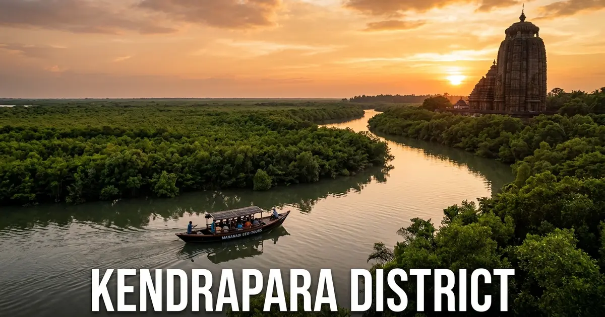
Kendrapara district occupies a distinguished position along the central coastline of Odisha, recognized worldwide for its extraordinary mangrove biodiversity, sacred spiritual traditions, and storied maritime history. Known spiritually as Tulasi Kshetra, this fertile deltaic land is anchored by the historic Sri Baladevjew Temple, where Lord Balarama is venerated as the primary presiding deity alongside Lord Jagannath and Goddess Subhadra.
Along its northeastern marine frontier lies Bhitarkanika National Park, the second-largest mangrove wetland ecosystem in India and a designated Ramsar wetland of international importance. Winding tidal rivers shelter the world’s largest concentration of giant saltwater crocodiles, while nearby Gahirmatha Marine Sanctuary hosts the planet’s most prolific nesting rookery for endangered Olive Ridley sea turtles.
Beyond ecological reserves, Kendrapara possesses an inspiring intellectual and cultural legacy. The district maintains one of the highest literacy rates in Odisha at over 85 percent, celebrates its renowned GI-tagged culinary treasure Kendrapada Rasabali, and preserves the historic 19th-century offshore monument of Hukitola.
Key Takeaways
- Kendrapara covers 2,644 square kilometers across one administrative subdivision, nine blocks, and nine tehsils.
- The district recorded a population of 1,440,218 in Census 2011, featuring a positive sex ratio of 1,006 females per 1,000 males and an impressive 85.15 percent literacy rate.
- Bhitarkanika National Park protects massive saltwater crocodiles, eight kingfisher species, and ancient mangrove tree species across tidal creeks.
- Sri Baladevjew Temple anchors Tulasi Kshetra, famous for its colossal Brahma Taladhwaja chariot, which stands taller than Puri’s Nandighosa chariot.
- Key cultural and heritage highlights include the GI-tagged Kendrapada Rasabali sweet, offshore Hukitola building, historic False Point Lighthouse, and golden grass Kaincha crafts.
Introduction to Kendrapara: Mangrove Wetlands, Sacred Shrines & Maritime Heritage
Kendrapara is located on the coastal delta of Odisha, bordered by Bhadrak district to the north, Jajpur district to the northwest, Cuttack district to the west, Jagatsinghpur district to the south, and the Bay of Bengal to the east. The administrative headquarters is Kendrapara town, situated approximately 85 kilometers northeast of the state capital, Bhubaneswar.
Historically an integral part of the historic parent territory of Cuttack district, Kendrapara was established as an independent revenue district on 1 April 1993. The district covers 2,644 square kilometers, characterized by flat alluvial delta plains dissected by tidal rivers, creeks, and coastal saline wetlands.
Motor vehicle administration operates under the regional transport code OD-29, managed by the Regional Transport Office in Kendrapara town.
| Geographic Metric | Canonical Statistic | Regional Context |
|---|---|---|
| Total Geographical Area | 2,644 sq km | Coastal river delta and mangrove district |
| District Headquarters | Kendrapara Town (Tulasi Kshetra) | Ancient spiritual center and administrative capital |
| Sub-Divisional Urban Centers | Kendrapara Sadar, Pattamundai | Administrative, commercial, and educational hubs |
| Geographic Coordinates | 20°20’ N – 20°37’ N, 86°14’ E – 87°01’ E | Central coastal plains and Bay of Bengal maritime rim |
| Average Elevation | 13 meters (43 feet) above sea level | Low-lying coastal floodplains and mangrove estuaries |
| Forest & Wetland Cover | 519 sq km | Over 19.63% of district area, primarily mangrove reserves |
| Motor Vehicle Registration (RTO) | OD-29 | Regional Transport Office, Kendrapara |
The climate of Kendrapara is tropical and humid, strongly influenced by its maritime proximity to the Bay of Bengal. Summers from March to June bring warm temperatures with high humidity, with afternoon sea breezes providing moderation along coastal villages.
The southwest monsoon delivers an average annual precipitation of 1,556 millimeters between June and October. This rainfall swells the river systems and flushes coastal estuaries with freshwater, supporting rich mangrove growth and brackish aquaculture.
Official government communications and environmental travel advisories are regularly published through the Odisha Tourism Official Portal and district administration archives.
Geographical Landscape, Deltaic River Networks & Mangrove Estuaries
The physical geography of Kendrapara represents a classic coastal delta formed by the interlocking distributaries of the Mahanadi, Brahmani, and Baitarani river systems. The district features virtually flat terrain, sloping gently eastward toward the maritime shoreline of the Bay of Bengal.
To the north, Kendrapara borders its coastal neighbor of Bhadrak district across the Dhamra estuary, where the combined waters of the Brahmani and Baitarani empty into the sea. The interior landscape is an intricate maze of fertile river channels, canals, and freshwater ponds.
The hydrological network of Kendrapara comprises multiple mighty rivers, distributaries, and tidal channels:
- Brahmani River: The second-longest river in Odisha, entering from Jajpur and branching into multiple channels before forming the southern boundary of Bhitarkanika.
- Baitarani River: Flows along the northern border, uniting with the Brahmani system to create the expansive Dhamra estuary.
- Kharasrota River: A major perennial branch of the Brahmani that meanders through Pattamundai and Aul blocks before discharging into the mangrove creeks.
- Luna & Chitrotpala Rivers: Important deltaic distributaries of the Mahanadi system that irrigate southern agricultural blocks like Marsaghai and Garadpur.
- Gobari & Hansua Rivers: Tidal rivers flowing past Kendrapara town and Mahakalapada, historically utilized for coastal barge traffic and inland navigation.
- Bhitarkanika Tidal Creeks: An intricate labyrinth of brackish creeks including the Suajore, Baunsagada, and Righagada that circulate seawater through mangrove forests.
The coastal fringe consists of dynamic barrier islands, mudflats, and sand spits that shift seasonally under the action of oceanic waves and tidal currents.
These coastal mangrove buffers provide indispensable natural defense against severe tropical cyclones, absorbing storm surges and protecting inland farming communities.
Historical Evolution: Ancient Maritime Kalinga, Royal Estates to Modern Formation
The historical legacy of Kendrapara stretches across centuries of maritime commerce, royal dynastic patronage, and heroic anti-colonial resilience. In ancient times, the estuarine ports along the Brahmani and Mahanadi deltas served as key embarkation harbors for the legendary Sadhabas (ancient Odia sea merchants) voyaging to Java, Sumatra, Bali, and Ceylon.
The territory came under the rule of the Bhauma-Karas, Somavamshis, and imperial Gangas. During the medieval period, the local Rajas of Kanika and Aul established fortified riverside seats, exercising feudal authority over the agricultural delta and maritime fishing grounds.
In the late 16th and early 17th centuries, Kendrapara faced repetitive incursions from Mughal forces. In 1661 CE, Mughal general Khan-i-Duran demolished the original Baladevjew temple in Kendrapara town, prompting devout priests to hide the sacred deities in forested hideouts before King Gopal Das of Kujanga consecrated the present grand temple at Ichhapur in 1761 CE.
Key historical milestones in Kendrapara’s journey include:
- Ancient Maritime Era: Prosperous seafaring trade conducted through estuarine harbors like False Point, exporting fine textiles, spices, and paddy across Southeast Asia.
- 1761 CE: Completion and consecration of the magnificent Sri Baladevjew Temple complex at Ichhapur by the local Maratha and Kujanga patrons.
- 1838 CE: Construction and lighting of the historic False Point Lighthouse, the oldest functional coastal lighthouse in eastern India.
- 1867 CE: Construction of the fortified Hukitola building by the British colonial administration as an offshore grain repository following the devastating Na’Anka famine of 1866.
- 1869 CE: Establishment of Kendrapara Municipality, one of the oldest urban local civic bodies in Odisha.
- 1993 CE: Formal reorganization on 1 April, establishing Kendrapara as an independent revenue district bifurcated from undivided Cuttack district.
The royal dynasties of Aul and Kanika played a notable role in supporting traditional literature, classical music, and freedom fighters during the national independence movement.
Today, preserved palace archives, stone temple walls, and colonial maritime structures provide visitors with tangible connections to this rich historical continuum. Further details are accessible on the Kendrapara District Administration Profile.
Administrative Framework: Subdivisions, 9 Blocks, Tehsils & Civic Governance
Kendrapara is governed under the jurisdiction of the Revenue Divisional Commissioner of the Central Division, based in Cuttack. Executive administration is directed by the Collector and District Magistrate in Kendrapara, supported by the Superintendent of Police for maintaining public peace and coastal security.
Unlike many larger western districts, Kendrapara is organized into a single administrative subdivision: Kendrapara Sadar. The territory is divided into nine community development blocks, nine tehsils, and 249 gram panchayats.
Urban civic management is handled by two municipal councils, delivering sanitation, drinking water, street illumination, and municipal infrastructure.
| Administrative Unit | Classification | Key Centers & Geographic Coverage |
|---|---|---|
| Kendrapara Sadar Subdivision | Administrative Subdivision | Encompasses the entire district territory across 9 blocks |
| Kendrapara Municipality | Urban Local Body (ULB) | District headquarters, historic Tulasi Kshetra, commercial core |
| Pattamundai Municipality | Urban Local Body (ULB) | Major agricultural market, educational hub, plumbing artisan center |
| Aul (Ali) Block | Community Development Block | Historic royal riverside estate along the Kharasrota River |
| Rajnagar Block | Community Development Block | Gateway to Bhitarkanika National Park and Gahirmatha coastline |
| Mahakalapada Block | Community Development Block | Maritime estuarine block, access point for Hukitola and False Point |
| Gram Panchayats | Rural Local Governance | 249 village clusters coordinating rural development programs |
Legislative representation includes five assembly constituencies: Kendrapara (SC), Patkura, Aul, Rajanagar, and Mahakalapada. The entire district unites under the Kendrapara Parliamentary Constituency in the Lok Sabha.
Decentralized governance through block offices has modernized saline embankments, constructed disaster-resilient cyclone shelters, and expanded piped rural water supply under the Jal Jeevan Mission.
Administrative initiatives have also enhanced eco-tourism infrastructure around Bhitarkanika, promoting community-based nature camps and sustainable livelihoods for local villagers.
Demographic Profile & Educational Excellence: Census 2011 Analysis
According to the official Census 2011 records, Kendrapara district has a total population of 1,440,218 persons, comprising 717,869 males and 722,349 females. A significant demographic feature is its positive sex ratio of 1,006 females per 1,000 males, well above both the Odisha state average of 979 and the national benchmark of 940.
The population density stands at 545 persons per square kilometer, reflecting the fertile agricultural nature of the coastal delta and high rural habitations.
Kendrapara stands out across Odisha for its educational achievements, recording a remarkable literacy rate of 85.15 percent in 2011. Male literacy reached 91.52 percent, while female literacy stood at 78.88 percent, ranking among the top educational districts in eastern India.
| Demographic Indicator | Census 2011 Measurement | Comparative Significance |
|---|---|---|
| Total Population | 1,440,218 | Approximately 3.43% of Odisha’s total population |
| Male Population | 717,869 | 49.84% of total district residents |
| Female Population | 722,349 | 50.16% of total district residents |
| Sex Ratio | 1,006 females / 1,000 males | High positive sex ratio reflecting social balance |
| Population Density | 545 persons / sq km | Dense coastal agrarian settlement |
| Overall Literacy Rate | 85.15% | One of the highest district literacy rates in Odisha |
| Male Literacy Rate | 91.52% | Exceptional educational attainment |
| Female Literacy Rate | 78.88% | Far exceeds state and national female literacy averages |
| Scheduled Caste (SC) Proportion | 21.36% | Substantial presence in agriculture, fishing, and crafts |
| Scheduled Tribe (ST) Proportion | 0.70% | Minimal tribal population across the coastal delta |
The social composition of Kendrapara is characterized by a strong Scheduled Caste presence (21.36 percent), actively participating in farming, marine fisheries, and handloom crafts.
The Scheduled Tribe population represents less than one percent, as the delta plains have historically been settled by agrarian, artisanal, and maritime coastal communities.
The high literacy rate has driven remarkable civic engagement, literature appreciation, and professional out-migration into specialized national engineering and skilled trades.
Coastal Economy: Delta Agriculture, Marine Fisheries & Pattamundai Diaspora
The economy of Kendrapara is anchored in coastal delta agriculture, extensive marine and brackish-water fisheries, and a nationally renowned skilled trade diaspora. The fertile alluvial soils between the Brahmani and Luna rivers support intensive paddy farming, pulses, oilseeds, and vegetables.
In low-lying coastal tracts prone to tidal inundation, farmers cultivate traditional salt-tolerant paddy varieties alongside modern hybrid varieties in inland blocks like Derabish and Garadpur.
Fisheries represent a primary economic engine, utilizing hundreds of kilometers of estuarine waterways and marine coastal waters.
Key dimensions of Kendrapara’s regional economy include:
- Marine & Estuarine Fisheries: Thousands of coastal fishermen operate motorized trawlers and gillnetters from landing centers at Kharinasi, Jamboo, and Talchua.
- Brackish-Water Aquaculture: Modern scientific farming of Black Tiger shrimp (Penaeus monodon) and Pacific White shrimp (Litopenaeus vannamei) for commercial export.
- The Pattamundai Plumbing Diaspora: Pattamundai block is nationally famous as the “Plumbing Capital of India”, having trained generations of master plumbers who work on major construction projects across Mumbai, Delhi, Bengaluru, Dubai, and the Gulf.
- Coconut & Betel Vine Cultivation: Lush coconut groves and shaded betel leaf (paan) plantations thrive along saline creeks in Mahakalapada and Rajnagar.
- Jute & Coir Agro-Enterprises: Riverine silt soils provide excellent conditions for jute cultivation, supporting traditional rope-making and packaging materials.
Remittances sent home by skilled plumbers and construction professionals from Pattamundai have transformed the rural landscape, financing modern concrete homes and rural educational trusts.
This combination of traditional coastal resources and specialized modern trade skills creates a stable, diverse economic base across the district.
Ecological Jewel of India: Bhitarkanika National Park & Crocodile Sanctuary
Covering 672 square kilometers of estuarine mangrove wetlands in the northeastern corner of Kendrapara, Bhitarkanika National Park & Wildlife Sanctuary is widely celebrated as one of Asia’s most magnificent ecological wonderlands. Gazetted as a wildlife sanctuary in 1975 and upgraded to a national park in 1998, it was designated as a Ramsar Wetland of International Importance in 2002.
Bhitarkanika preserves the second-largest contiguous mangrove ecosystem in the Indian subcontinent after the Sundarbans. The park is fed by the tidal waters of the Brahmani, Baitarani, and Dhamra rivers, creating a dynamic brackish habitat that supports over 60 distinct species of true mangroves and mangrove associates.
The defining conservation success of Bhitarkanika is its flourishing population of Saltwater Crocodiles (Crocodylus porosus). From just 96 individuals in 1975, rigorous conservation has expanded the population to more than 1,800 crocodiles today, including massive specimens measuring over 20 feet in length.
Key ecological highlights of Bhitarkanika National Park include:
- Saltwater Crocodile Nursery: Dangamal Crocodile Research Centre features captive breeding ponds, an interpretation museum, and the preserved skeleton of a 23-foot crocodile.
- Bagagahan Heronry: A world-renowned breeding colony where more than 50,000 migratory waterbirds, including Asian openbill storks, night herons, egrets, and darters, nest between June and November.
- Kingfisher Diversity: The mangrove waterways shelter eight distinct species of kingfishers, including the rare brown-winged kingfisher, pied kingfisher, and black-capped kingfisher.
- Mammalian Fauna: Abundant herds of spotted deer (chital), wild boar, rhesus macaques, fishing cats, Asian water monitor lizards, and smooth-coated otters.
- Tidal Boat Safaris: Eco-friendly motor launches departing from Khola and Gupti gates travel along narrow creeks flanked by dense mangrove root networks.
Walking along the designated nature trail at Dangamal leads visitors through medieval temple ruins, ancient hunting towers, and lotus-filled ponds under canopies of towering sundari and bani trees.
A safari through Bhitarkanika offers an intimate encounter with an ancient estuarine ecosystem. Further scientific survey details are documented on the Bhitarkanika National Park Wetland Profile.
Marine Sanctuaries & Sea Turtle Rookeries: Gahirmatha & Olive Ridley Nesting
Bordering the eastern seaward boundary of Bhitarkanika lies the Gahirmatha Marine Sanctuary, established in 1997 to safeguard the world’s most critical mass nesting sanctuary for endangered Olive Ridley sea turtles (Lepidochelys olivacea). The sanctuary encompasses 1,435 square kilometers of coastal waters and offshore marine zones stretching from the Dhamra river mouth to the Mahanadi mouth.
Every winter between November and May, hundreds of thousands of Olive Ridley sea turtles migrate thousands of kilometers across the southern oceans to mate in the shallow offshore waters of Gahirmatha.
The natural climax of this migration is the miraculous phenomenon known in Odia as Arribada (mass arrival), when countless female turtles emerge simultaneously onto narrow sandy beaches under the cover of night to lay eggs.
Key facets of the Gahirmatha marine conservation sanctuary include:
- World’s Largest Rookery: Gahirmatha regularly hosts mass nesting events where over 300,000 to 500,000 sea turtles lay eggs on the isolated sand spits of Ekakula and Nasi Islands.
- Stringent Marine Protection: The state forest department and Indian Coast Guard enforce mechanized fishing bans within 20 kilometers of the coastline during the nesting season to prevent turtle mortality.
- Hatchling Emergence: Approximately 45 to 50 days after nesting, millions of tiny turtle hatchlings emerge from underground sand nests and crawl instinctively toward the open ocean under moonlight.
- Marine Biodiversity: The sanctuary waters also harbor Indo-Pacific humpback dolphins, bottle-nosed dolphins, sea snakes, and diverse species of marine pelagic fish.
Due to the fragile nature of sea turtle nesting, public tourist access to the isolated nesting sand spits is strictly restricted during peak Arribada periods.
However, visitors can observe breeding turtles in shallow coastal waters during daytime boat safaris conducted from authorized forest entry points.
Sacred Citadel of Tulasi Kshetra: Sri Baladevjew Temple & Brahma Taladhwaja
The spiritual soul of Kendrapara resides within the sanctum of the Sri Baladevjew Temple, situated in Ichhapur on the outskirts of Kendrapara town. Revered across eastern India as Tulasi Kshetra, this sacred complex holds equal spiritual significance with the other three holy realms of Odisha: Shankha Kshetra (Puri), Padma Kshetra (Konark), and Ekamra Kshetra (Bhubaneswar).
The temple is uniquely dedicated to Lord Baladevjew (Balarama) as the primary presiding deity, seated alongside his younger brother Lord Jagannath, sister Goddess Subhadra, and the sacred Sudarshana Chakra.
The temple complex is enclosed by massive high stone walls known as the Meghnad Pacheri, containing multiple halls built in classic Kalinga architectural tradition.
Devotees comparing sacred shrines often evaluate Baladevjew alongside other celebrated architectural temples across Odisha to study distinctive regional traditions.
Key architectural and ritual traditions of the Sri Baladevjew Temple include:
- Brahma Taladhwaja Chariot: The annual Rath Yatra of Baladevjew features a colossal wooden chariot called Brahma Taladhwaja, measuring approximately 49 feet in height, standing taller than the main chariot in Puri.
- Consecrated Mahaprasad: The temple kitchen prepares delicious consecrated vegetarian offerings, including traditional ghee rice, dalma, kanika, and mouthwatering sweet pitha.
- Jhulan Yatra Celebrations: An elaborate monsoon swing festival observed in the month of Shravana, where beautifully decorated miniature idols are placed on ornate swings.
- Seven Sanctified Courtyards: The temple precinct contains the Vimana, Jaga Mohana, Natamandapa, and Bhoga Mandapa, surrounded by auxiliary shrines dedicated to Goddess Tulasi and various avatars.
The atmosphere inside the temple courtyard is tranquil, shaded by ancient banyan and neem trees where pilgrims gather to chant devotional verses.
A visit to Baladevjew Temple offers travelers a deep experience of classical Odia Vaishnavite devotion. Further architectural documentation is preserved on the Baladevjew Temple Heritage Monograph.
Offshore Strongholds & Maritime Relics: Hukitola Monument & False Point Lighthouse
Kendrapara houses rare and captivating maritime architectural monuments dating from the British colonial era, located along the isolated coastal islands near the Mahanadi estuary. Foremost among these is the historic Hukitola Building, situated on the uninhabited island of Hukitola near Jambu.
Constructed in 1867 under the supervision of British engineer Captain H. L. Thuillier following the catastrophic Na’Anka famine of 1866, this monumental stone edifice was designed as a fortified offshore rice storage depot and storm refuge.
Built entirely from massive laterite stone blocks with a rainwater harvesting roof and subterranean cellars, the building stands as an enduring engineering achievement.
Travelers exploring coastal navigation links frequently connect this heritage with the neighboring maritime corridor of Jagatsinghpur district across the southern boundary of the delta.
Key maritime heritage sites in Kendrapara include:
- Hukitola Island Building: A 19th-century offshore stone complex featuring 14 massive halls, arched verandas, and a sophisticated central freshwater filtration system that collected rainwater.
- False Point Lighthouse: Commissioned in 1838 at the mouth of the Mahanadi estuary, this 129-foot circular granite tower is the oldest operating lighthouse on the eastern coast of India.
- Historic False Point Port Ruins: Preserved remnants of colonial maritime custom offices, harbor quays, and anchorage buoys that handled steamships between Calcutta and Britain.
- Batighar Island Village: A peaceful coastal hamlet surrounding the False Point lighthouse, accessible only by motorized riverboat through mangrove creeks.
Reaching Hukitola and False Point requires an unforgettable boat journey from the fishing jetties at Ramnagar or Kharinasi across wide estuarine channels.
As the boat glides past coastal mudflats, travelers frequently observe pods of leaping estuarine dolphins and flocks of migratory sea terns.
Royal Legacies & Riverfront Estates: Aul Palace & Kanika Rajbati
The riverside banks of Kendrapara preserve magnificent royal palaces that reflect the architectural grandeur and cultural patronage of regional feudal rulers. The most renowned royal seat is the Aul Palace (Ali Rajbati), situated gracefully along the banks of the Kharasrota River in Aul block.
Dating back to the 16th century, the palace served as the royal residence of the Rajas of Aul, who claimed direct descent from the medieval Gajapati kings of Odisha.
The palace complex displays an elegant combination of traditional Odia defensive architecture and colonial Indo-Saracenic elements, featuring expansive festival courtyards, carved wooden balconies, and arched entrance gateways.
Further north in Rajkanika block stands the majestic Kanika Palace (Kanika Rajbati), the historic ancestral seat of the influential Rajas of Kanika.
Key highlights of Kendrapara’s royal palaces include:
- Aul Palace Riverside Ghat: A private stone flight of steps descending to the Kharasrota River, historically used for royal boat processions and ceremonial temple dips.
- Kanika Palace Library & Armory: Preserves valuable medieval palm-leaf manuscripts, royal correspondence, and antique swords, matchlock rifles, and shields.
- World-Record Crocodile Skull: The Kanika Palace museum houses the preserved skull of an enormous 23-foot saltwater crocodile shot in 1926, recognized in the Guinness Book of World Records.
- Historic Temples of Aul: Ancient stone shrines dedicated to Lord Baraha and Goddess Biraja situated within walking distance of the palace grounds.
While these palaces remain private family estates, exterior views from the riverside riverbanks offer photographers and heritage lovers captivating vistas of historic aristocratic life.
Exploring these royal riverfronts provides travelers with a unique window into the feudal politics and literary patronage that shaped coastal Odisha.
Golden Eco-Craft: Hand-Woven Golden Grass (Kaincha) Art of Kendrapara
Kendrapara is widely acclaimed across India for its exquisite eco-friendly handicraft tradition known as Golden Grass Craft (Kaincha Craft). Kaincha is a wild, golden-yellow aquatic reed (Vetiveria zizanioides) that grows abundantly along the wet riverbanks, marshy channels, and swampy depressions across the district.
For generations, skilled rural women artisans have harvested, dried, and split this natural reed, weaving it into an impressive assortment of durable, biodegradable utility products and decorative items.
Today, golden grass weaving provides vital independent livelihoods to thousands of rural women organized through self-help groups (SHGs) under Mission Shakti.
Distinctive features of authentic Kendrapara Golden Grass craft include:
- Natural Lustre & Golden Color: When dried in natural sunlight, Kaincha acquires a beautiful golden sheen that requires no artificial chemical lacquers or harmful dyes.
- Diverse Functional Items: Master artisans craft sturdy laundry baskets, fruit bowls, table mats, hand fans, fashionable tote bags, jewelry boxes, and decorative wall hangings.
- Fine Twill & Braid Weaving: The crafting technique involves intricate hand braiding and spiral coiling, creating items that are surprisingly strong, lightweight, and long-lasting.
- National Artisan Awards: Weavers from villages like Jajpur, Baro, and Pattamundai have won prestigious national handicrafts awards for their innovation and intricate workmanship.
Purchasing authentic golden grass crafts directly from artisan cooperatives in Kendrapara or official government fair exhibitions supports rural women’s economic independence.
These elegant, eco-friendly creations represent a harmonious marriage of natural coastal wetlands and sustainable rural artistic traditions.
Gastronomic Icon: The GI-Tagged Kendrapada Rasabali & Coastal Flavors
The culinary pride of Kendrapara centers upon one of the most celebrated sweet delicacies of eastern India: Kendrapada Rasabali. Deeply intertwined with the sacred rituals of the Sri Baladevjew Temple for over four centuries, Rasabali holds prestigious Geographical Indication (GI) status recognition for its exceptional heritage.
Rasabali is prepared through a meticulous culinary process using fresh cow milk cottage cheese (chhena), seasoned with a touch of flour and cardamom.
The chhena is kneaded into soft flattened patties, gently deep-fried in pure desi ghee until reddish-brown, and then steeped for hours in rich, thick rabri (condensed milk) infused with crushed green cardamom and saffron.
Key culinary specialties that travelers must enjoy in Kendrapara include:
- Kendrapada Rasabali (GI Tagged): Soft, spongy chhena patties soaked in rich, aromatic condensed milk, melting gently on the palate with delicate floral sweetness.
- Baladevjew Temple Mahaprasad: A sacred vegetarian spread comprising earthen-pot cooked rice, dalma, kanika sweet rice, and regional vegetable curries.
- Pattamundai Chhena Gaja: Dense, crispy golden-brown squares of baked cottage cheese, soaked in light cardamom sugar syrup.
- Brahmani River Fish & Prawn Curries: Fresh river fish, giant tiger prawns, and mud crabs cooked in spicy mustard paste (besara) with green chilies and garlic.
- Kendrapara Mudhi & Ghuguni: Puffed rice served hot with spiced yellow pea curry, chopped onions, and fresh coriander at evening roadside stalls.
Tasting fresh Rasabali at renowned sweet stalls near the Baladevjew temple gates or in Kendrapara town market provides an unforgettable culinary highlight.
The culinary heritage of Kendrapara celebrates dairy richness, fresh coastal catches, and traditional confectionary mastery. A historical overview can be reviewed on the Kendrapada Rasabali Geographical Indication Dossier.
Transportation & Transit Logistics: Reaching and Navigating Kendrapara
Reaching and navigating Kendrapara is straightforward, facilitated by upgraded national highway corridors, well-surfaced state highways, and expanding railway connections.
The district headquarters, Kendrapara town, is positioned along State Highway 9A (Cuttack-Chandbali road) and is directly accessible from National Highway 53.
The comprehensive transit matrix below provides clear travel routes and operational hubs for prospective visitors:
| Mode of Transport | Primary Hubs & Routes | Connectivity Details & Operational Status |
|---|---|---|
| Air Travel | Biju Patnaik International Airport, Bhubaneswar (BBI - 85 km) | Operates daily domestic flights across India and international direct connections |
| Rail Transport | Cuttack Junction (CTC - 55 km) / Kendrapara Road (KENP) / Jajpur Keonjhar Road (70 km) | Cuttack is a major rail hub; Haridaspur-Paradip railway line serves local freight and passenger transit |
| National Highways | NH-53 (Chandikhole-Paradip) / NH-16 (connecting at Chandikhole) | Four-lane expressways offering fast road links from Bhubaneswar, Cuttack, and Kolkata |
| State Highways | State Highway 9A (Cuttack-Kendrapara-Pattamundai-Chandbali) | Smooth two-lane arterial road providing direct access through the heart of the district |
| Intercity Bus Service | Kendrapara Old & New Bus Stands | Continuous bus departures to Cuttack (every 10 minutes), Bhubaneswar, Paradip, and Bhadrak |
From Cuttack Railway Station, frequent government and private express buses depart every 10 to 15 minutes, completing the journey to Kendrapara town in approximately 75 minutes.
Travelers heading to Bhitarkanika National Park should take buses or private rental taxis from Kendrapara town via Pattamundai to Rajnagar (45 km) and on to Khola Gate or Gupti Gate (another 20 km), where authorized forest safari boats depart.
Rental cars, shared jeeps, and auto-rickshaws are widely available at Kendrapara, Pattamundai, and Rajnagar for flexible daily excursions.
Seasonal Weather & Optimal Travel Timings
Understanding coastal Odisha’s tropical weather cycles is essential when organizing a trip to Kendrapara, particularly for wildlife viewing and boat safaris in Bhitarkanika. The maritime location produces humid summer conditions, while post-monsoon and winter months offer pleasant outdoor temperatures.
The seasonal breakdown below outlines climate trends, temperature ranges, and practical travel guidance across the year:
| Season | Calendar Months | Temperature Range | Weather Characteristics | Travel Feasibility & Advice |
|---|---|---|---|---|
| Winter | October to February | 14°C – 28°C | Cool morning breezes; mild sunny afternoons | Peak Travel Season: Ideal for Bhitarkanika safaris, crocodile basking, birdwatching, and temple tours |
| Summer | March to June | 26°C – 39°C | Warm, humid afternoons; pleasant coastal evening breezes | Wildlife viewing viable during early morning boat rides; carry hydration and sun protection |
| Monsoon | July to September | 25°C – 33°C | Heavy coastal rainfall; swollen rivers and creeks | Park breeding season closures; excellent for Bagagahan heronry bird nesting |
The ideal period to visit Kendrapara district is from October through February. During these winter months, comfortable temperatures make boat cruises through Bhitarkanika exceptionally rewarding, as giant saltwater crocodiles emerge onto sunny mudbanks to bask for hours.
Winter also brings thousands of migratory waterbirds to the Bagagahan heronry and surrounding wetlands, delighting nature photographers and ornithologists.
Note that Bhitarkanika National Park is officially closed to tourists for approximately ten days in January for the annual crocodile and bird census, and again from May to July for crocodile nesting.
Summer months between April and June experience high coastal humidity, making early morning boat excursions the most comfortable option.
Accommodation, Eco-Tour Guidelines & Practical Travel Advice
Kendrapara provides a varied selection of hospitality accommodations, ranging from town hotels to comfortable forest nature camps. In Kendrapara town, quality budget and business hotels cluster around College Road, Tinikonia Bagicha, and Marshaghai Road, providing air-conditioned rooms and dining.
For visitors touring Bhitarkanika, the state forest department and OTDC operate excellent eco-resorts and nature camps at Dangamal, Gupti, and Habalikhati, featuring luxury tented cottages and local dining halls.
To ensure a safe, environmentally responsible, and fulfilling trip through Kendrapara, visitors should observe several key guidelines:
- Bhitarkanika Boat Booking Protocol: Book eco-tourism cottages and safari boat permits in advance through the official Eco Tour Odisha portal. Always hire registered forest guides and depart from authorized forest department entry gates at Khola or Gupti.
- Wildlife Safety Caution: Never attempt to step out of the safari boat onto mudbanks inside Bhitarkanika, as large saltwater crocodiles remain camouflaged near the waterline. Keep arms and cameras inside the boat railing at all times.
- Plastic-Free Sanctuary Rule: Bhitarkanika is a strictly enforced single-use plastic-free zone. Avoid carrying plastic bags, discard garbage only in designated bins, and carry reusable stainless-steel water flasks.
- Baladevjew Temple Etiquette: Leave leather shoes, belts, and wallets in vehicle lockers before entering the temple complex. Photography of the inner sanctum deities is prohibited; respect traditional temple customs and sevayats.
- Rasabali Authenticity Tip: To purchase genuine Kendrapada Rasabali, visit reputed sweet confectionaries near the main Baladevjew temple gate or established sweet shops on Kendrapara Main Road to ensure fresh preparation in pure desi ghee.
Frequently Asked Questions (FAQ) About Kendrapara District
What is Kendrapara district famous for?
Kendrapara district is famous across India for Bhitarkanika National Park, which protects the nation’s largest population of giant saltwater crocodiles and diverse mangrove forests. The district is equally renowned for the historic Sri Baladevjew Temple in Tulasi Kshetra, the famous GI-tagged Kendrapada Rasabali sweet, and the mass nesting rookeries of Olive Ridley sea turtles at Gahirmatha.
Why is Kendrapara known as Tulasi Kshetra?
Kendrapara is revered spiritually as Tulasi Kshetra because it is the primary sacred abode of Lord Baladevjew (Balarama), holding spiritual status alongside Puri, Konark, and Bhubaneswar. According to regional tradition, Lord Balarama defeated the demon Kandrasura here and married his daughter Tulasi, consecrating this holy river delta as his eternal sanctuary.
What makes Bhitarkanika National Park ecologically unique?
Bhitarkanika National Park is the second-largest mangrove wetland ecosystem in India and an internationally designated Ramsar site home to more than 1,800 saltwater crocodiles. The sanctuary also shelters eight species of colorful kingfishers, the world-famous Bagagahan migratory bird heronry, and protected mangrove channels that act as natural storm barriers.
What is Kendrapada Rasabali and when did it get GI status?
Kendrapada Rasabali is an iconic traditional sweet originating as a sacred ritual offering at the Sri Baladevjew Temple, officially awarded Geographical Indication (GI) status for its unique regional identity. The delicacy consists of deep-fried flattened cottage cheese (chhena) patties steeped in rich, thickened condensed milk infused with fragrant cardamom and saffron.
What is the best time of year to visit Kendrapara district?
The optimal time to visit Kendrapara is between October and February when comfortable winter weather brings mild temperatures ranging from 14°C to 28°C. These cool, sunny months provide ideal conditions for boat safaris to spot basking crocodiles in Bhitarkanika and exploring the sacred shrines of Tulasi Kshetra.