Raibania Fort Jaleswar Balasore: History, Timings & Guide
Explore Raibania Fort near Jaleswar in Balasore, Odisha. Discover the history of eastern India's largest medieval fort, timings, route, and architecture.
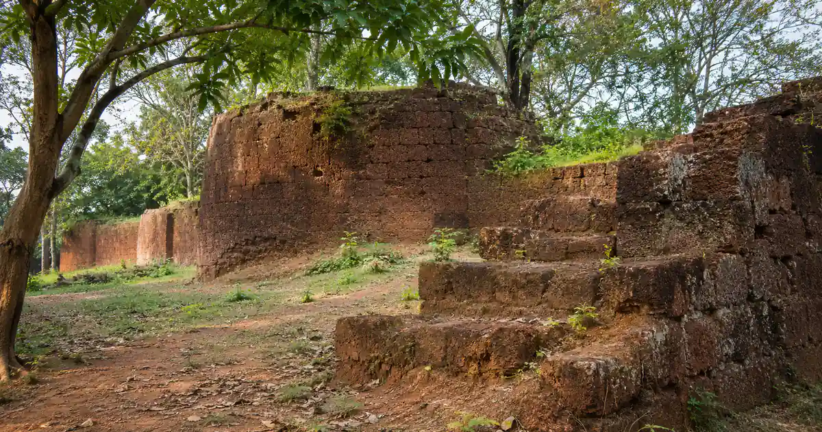
Rising silently amid northern Odisha near the Subarnarekha River, Raibania Fort Jaleswar Balasore stands as eastern India’s largest medieval military stronghold. Constructed in the thirteenth century by King Langula Narasingha Deva I, this colossal fort once guarded the northern frontier of the Kalinga empire.
Today, travelers and heritage enthusiasts can explore towering dressed laterite ramparts, ancient stone gateways, and centuries-old temple ruins hidden beneath rural greenery.
Key Takeaways
- Location & Setting: Situated in Raibania village within Jaleswar block, approximately 16 km northwest of Jaleswar town in northern Balasore district.
- Entry Fee & Timings: Free public entry. The open archaeological grounds remain open daily between 8:00 AM and 5:00 PM.
- Colossal Scale: Spans multiple square kilometers across four interconnected forts, making it larger than any other surviving medieval fort complex in eastern India.
- Accessibility: Located 16 km from Jaleswar railway station, 65 km north of Balasore city, and 95 km south of Kharagpur along the NH-16 highway corridor.
Raibania Fort Jaleswar Balasore at a Glance: Quick Timings, Fees & Key Facts
Raibania Fort offers an unforgettable journey into Odisha’s medieval military brilliance and territorial resilience. Before starting your expedition across these vast laterite ruins, review this essential reference table detailing visitor timings, access points, and practical site facts.
| Parameter | Verified Details | Notes |
|---|---|---|
| Location | Raibania, Jaleswar Block, Balasore District | 16 km northwest of Jaleswar near Subarnarekha River |
| Fort Foundation | 13th Century CE (c. 1238–1264 CE) | Built by Eastern Ganga King Langula Narasingha Deva I |
| Timings | Daily: 8:00 AM to 5:00 PM | Open every day from sunrise to sunset |
| Entry Fee | Free entry | No ticket counter; unrestricted public heritage site |
| Photography | Allowed freely | Excellent light for architectural and drone photography |
| Best Season | October to March | Mild daytime temperatures suitable for walking tours |
| Nearest Railway Station | Jaleswar (JLE, 16 km) / Balasore (BLS, 65 km) | Regular passenger and express trains on Howrah-Chennai line |
| Nearest Airport | Biju Patnaik International, Bhubaneswar (260 km) | Netaji Subhash Chandra Bose Airport, Kolkata is 175 km north |
Core Historical Highlights
Frequently documented in historical gazetteers as Raibanya fort Odisha, this citadel was not merely a single bastion, but a coordinated network comprising four distinct forts. The two larger forts were erected around modern Raibania, while two companion forts guarded nearby Phulahatta.
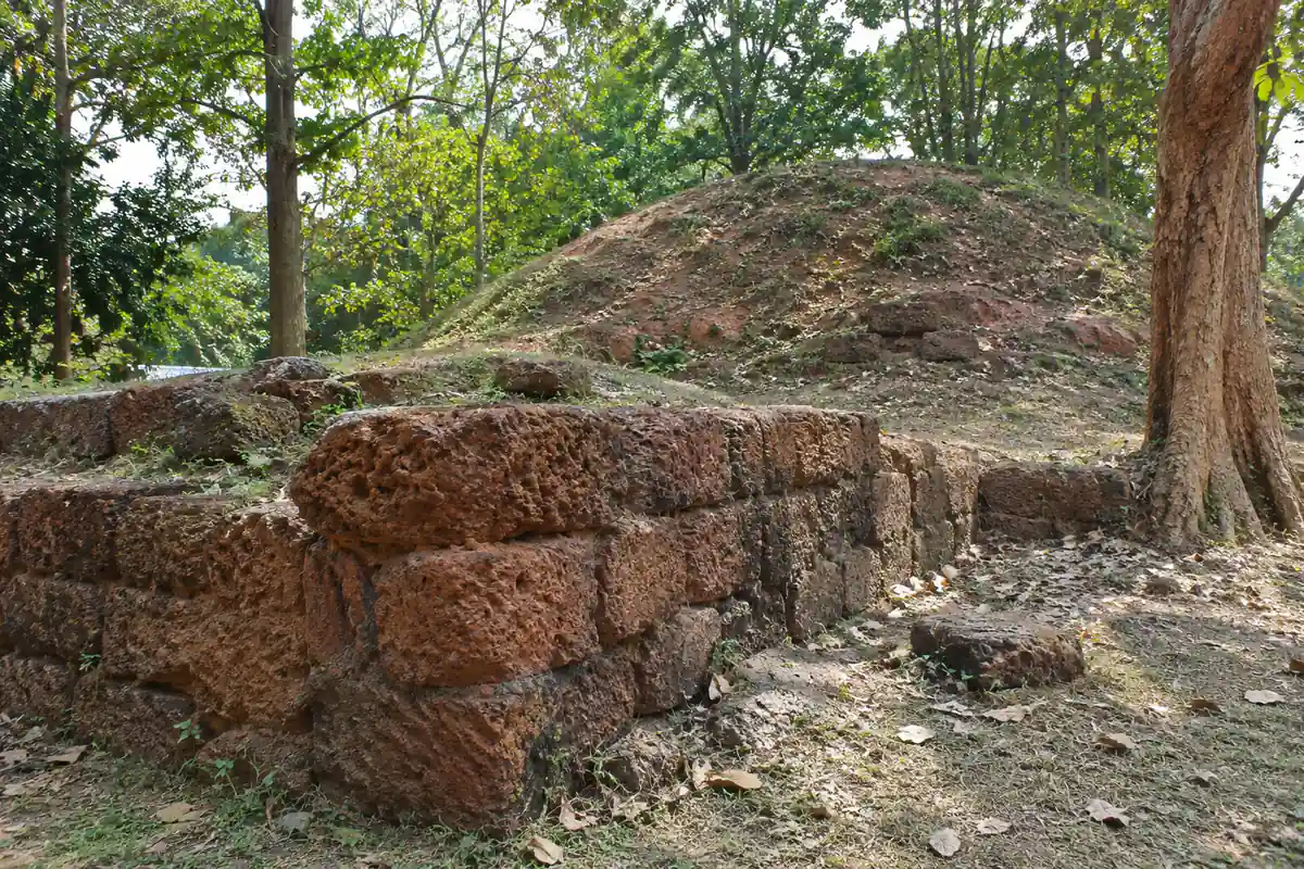
The entire defensive perimeter was built using enormous blocks of local laterite stone laid without lime mortar. Maintained under state heritage initiatives guided by the Official Balasore District Administration and Odisha Tourism Department, Raibania represents an essential stop in our Balasore district travel and heritage guide.
Who Will Appreciate Visiting Raibania Fort
History researchers and archaeology students will appreciate tracing the massive scale of 13th-century military engineering. The site retains deep moats (Gadha), ancient gateways, and sacrificial shrines that have survived over seven centuries.
Nature lovers and landscape photographers will also find beauty in the weathered stone walls framed by flowering mango orchards and rustic village ponds. Because the ruins are spread across expansive rural terrain, visitors should expect moderate cross-country walking.
The Epic History of Eastern India’s Largest Medieval Fort
The establishment of Raibania Fort is intimately linked with the golden age of the Eastern Ganga Dynasty. King Langula Narasingha Deva I, renowned globally as the builder of the magnificent Sun Temple at Konark, ruled an empire spanning from the Hooghly in Bengal to the Godavari in the south.
| Historical Phase | Period | Strategic Milestone |
|---|---|---|
| Ganga Dynasty Ascendancy | 1238–1264 CE | King Narasingha Deva I builds Raibania to repel northern invaders |
| Mughal Administrative Surveys | 1590s CE | Documented as “Rayn” with three massive forts in Ain-i-Akbari |
| British Archaeological Study | 1872 CE | Collector John Beames surveys and documents the four-fort network |
| Modern Heritage Status | 20th–21st Century | Protected as a major monument by Odisha State Archaeology |
Langula Narasingha Deva I and the Northern Frontier Defense
During the middle of the thirteenth century, the rulers of the Delhi Sultanate and the Turkic governors of Bengal repeatedly launched aggressive military raids toward Odisha’s northern borders. Recognizing the strategic vulnerability of the Subarnarekha river basin, Narasingha Deva I chose Raibania as the site for an unyielding frontier garrison.
Odisha military engineers chose high ground bounded by river marshes, constructing massive ramparts that could shelter an entire army alongside cavalry, war elephants, and royal granaries. Historical records suggest that garrisons stationed at Raibania repeatedly drove back the armies of Tughral Tughan Khan, establishing Kalinga’s military dominance across the eastern seaboard.
Much like the sunken star-shaped Potagarh Fort in Ganjam secured the southern Rushikulya maritime corridor centuries later, Raibania served as the northern shield of ancient Odisha.
Records in the Mughal Ain-i-Akbari (16th Century)
Centuries after the fall of the Eastern Ganga Dynasty, Raibania continued to impress imperial cartographers and military chroniclers. In the late sixteenth century, Mughal historian Abul Fazl documented the complex in his celebrated administrative treatise, the Ain-i-Akbari.
Fazl recorded the location under the name Rayn, observing that the district contained three extraordinarily strong forts capable of housing large defensive garrisons. This imperial acknowledgment confirmed that Raibania remained a formidable military benchmark long after royal dynasties had shifted their capitals southward.
John Beames’ Pioneering 1872 Archaeological Survey
Modern knowledge of Raibania’s true dimensions is largely credited to John Beames, the visionary British Magistrate and Collector of Balasore. In 1872, Beames conducted an exhaustive field survey across the dense jungle that had overgrown the ruins.
Publishing his findings in the Indian Antiquary, Beames was astonished by the staggering scale of the laterite ramparts, recording that the main walls were so broad that horsemen could gallop along their crests. His detailed maps and architectural descriptions rescued Raibania from historical obscurity and established its status as eastern India’s greatest medieval fort.
Monumental Architecture and Defense Engineering
The architectural brilliance of Raibania Fort lies in its colossal defensive geometry and sophisticated water-harvesting systems. Unlike the laterite and sandstone ramparts seen at the historic Barabati Fort in Cuttack, Raibania relies entirely on massive dry-masonry laterite blocks fitted with interlocking precision.
Dressed Laterite Ramparts and Massive Defensive Moats
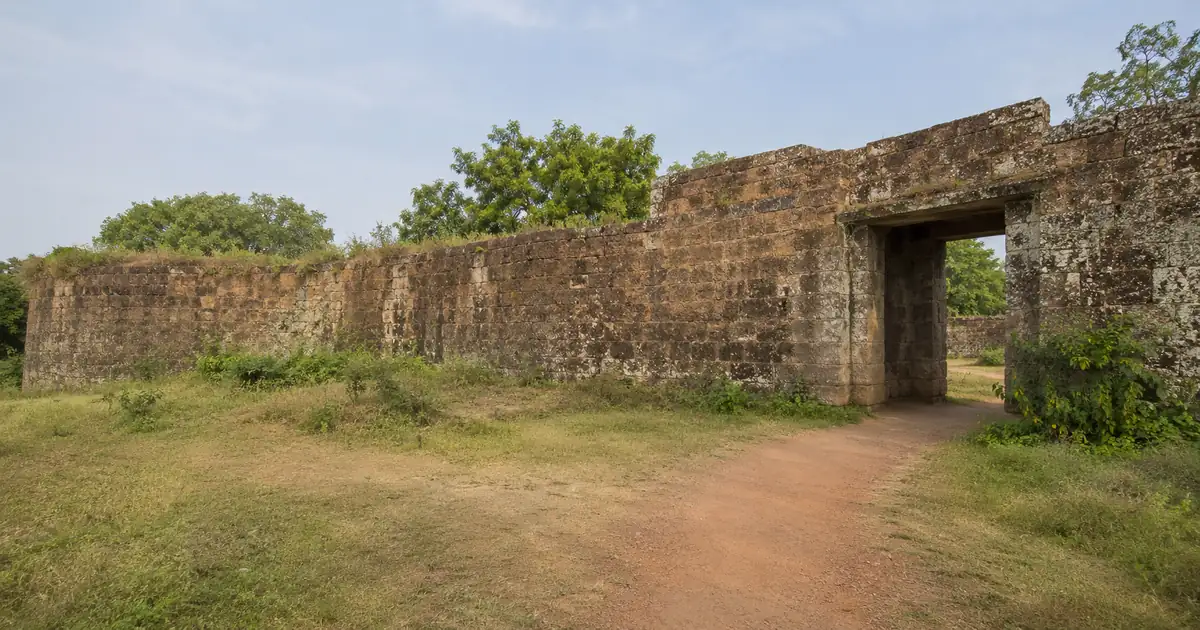
The perimeter wall of the main fortress rises nearly 25 to 30 feet from its foundation base. Masons dressed native porous laterite stone into uniform cubical blocks, stacking them without any mortar binding to form a wall wide enough to accommodate artillery and cavalry movements.
Encircling these laterite ramparts were concentric moats (Gadha), measuring over one hundred feet in width. Fed by seasonal streams and groundwater channels, these deep moats created an impassable water barrier against enemy infantry and battering rams.
The Historic Gateways: Singhadwar and Hatidwar
Access into the fort was restricted through heavily fortified monumental gateways. The most prominent surviving portal is the Singhadwar (Lion Gate), featuring towering stone jambs once flanked by carved royal guardian lions.
Another monumental entryway is the Hatidwar (Elephant Gate), engineered with wide stone ramps and elevated arch clearances to allow war elephants carrying armored howdahs to pass freely into the royal courtyard. A smaller concealed gate, known as Sunamukhidwar, provided a private egress point for scouts and administrative couriers.
Satagambhira Hall and the Sacred Jayachandi Temple
Within the inner precinct stands the enigmatic Satagambhira, or the Seven-Chambered Hall. Local historians believe this sunken stone pavilion served as a subterranean treasury, war council chamber, or retreat during intense summer heat.
Nearby sits the historic Jayachandi Temple, housing the tutelary goddess worshipped by Ganga warriors before marching into combat. Local villagers continue to perform daily rituals here, offering vermilion and wild flowers at the ancient sanctum.
Best Season to Visit Raibania Fort and Weather Insights
Northern Balasore experiences distinct seasons shaped by its inland river basin location near the West Bengal border. Timing your visit during the comfortable cooler months ensures an enjoyable outdoor walking experience.
Winter Exploration (October to March)
The months from October through March represent the optimal window for exploring Raibania Fort. Daytime temperatures range from 18°C to 27°C with crisp morning breezes and clear blue skies.
The cool weather makes it easy to walk the several kilometers of trails connecting the ramparts, Jayachandi shrine, and ancient water reservoirs. Photography during these months is exceptional, as soft winter sunlight illuminates the rusty red tones of the ancient laterite masonry.
Monsoon and Summer Realities
The monsoon season from June to September brings heavy rains that fill the ancient moats and turn the surrounding countryside bright green. However, wet undergrowth, slippery moss on stones, and muddy trails can make exploration challenging.
Summer months between April and June bring intense dry heat, with afternoon temperatures frequently climbing past 38°C. Travelers arriving in summer should schedule visits early between 7:30 AM and 10:00 AM, avoiding midday sun completely and carrying ample hydration.
How to Reach Raibania Fort Jaleswar: Road, Rail, and Air Directions
Raibania Fort is well-connected to major transit arteries in northern Odisha, making it an accessible day excursion from Jaleswar, Balasore, or Kolkata.
| Transit Hub | Distance to Fort | Recommended Travel Mode |
|---|---|---|
| Jaleswar Railway Station (JLE) | 16 km | Local auto-rickshaw or private taxi (30 minutes) |
| Balasore Railway Station (BLS) | 65 km | Private cab or express bus via NH-16 (1.5 hours) |
| Kolkata Airport (CCU) | 175 km | Outstation taxi or train via Kharagpur (3.5 hours) |
| Bhubaneswar Airport (BBI) | 260 km | Express train or coastal highway drive (5 hours) |
Reaching by Train via Jaleswar and Balasore
The most convenient railhead is Jaleswar Railway Station (station code: JLE), located merely 16 km southeast of the fort. Frequent express and passenger trains connecting Kolkata (Howrah/Shalimar) and Puri or Bhubaneswar stop here daily.
From Jaleswar station, travelers can hire auto-rickshaws for roughly ₹350 to ₹500 for a round-trip excursion including waiting time. Alternatively, Balasore Railway Station (BLS) provides national rail connectivity with premium express trains like Vande Bharat and Rajdhani.
Driving Routes via NH-16 and State Highways
Motorists traveling from Bhubaneswar or Cuttack should follow National Highway 16 north through Bhadrak and Balasore toward Jaleswar. Before entering Jaleswar town, turn west onto the Raibania connecting road near Laxmannath.
The road from Jaleswar to Raibania village is paved and passes through peaceful rural hamlets and green paddy terraces. Ample parking space is available near the entrance to the Jayachandi Temple complex.
Air Travel via Bhubaneswar and Kolkata Airports
Air travelers can fly into Netaji Subhash Chandra Bose International Airport (CCU) in Kolkata, which sits approximately 175 km north of Raibania. From Kolkata, one can board a comfortable two-hour train ride to Jaleswar.
Alternatively, travelers landing at Biju Patnaik International Airport (BBI) in Bhubaneswar can board express trains heading northward to Jaleswar, enjoying a smooth four-hour rail journey across coastal Odisha.
Nearby Attractions in the Balasore Tourism Circuit
A morning visit to Raibania Fort pairs naturally with several other world-class religious and coastal destinations across northern Balasore district.
Spiritual Heritage at Chandaneswar Shiva Temple
Located about 35 km southeast of Raibania, the sacred Chandaneswar Shiva Temple is one of the most revered pilgrimage shrines in eastern India. Dedicated to Lord Shiva, the temple draws thousands of devotees, especially during the annual Chadak Mela in April.
Pilgrims often combine a morning darshan at Chandaneswar with an afternoon heritage walk among the laterite walls of Raibania.
Red Crabs and Serenity at Talsari Beach
Just 5 km beyond Chandaneswar lies the tranquil shoreline of Talsari Beach. Sheltered by whispering casuarina groves and calm river backwaters, Talsari is famed for its colonies of red ghost crabs scuttling across wide sand dunes.
Visitors can enjoy fresh tender coconut water, hire local motorized boats to cross the shallow creek, and savor freshly prepared seafood at rustic coastal eateries.
Vanishing Sea Phenomenon at Chandipur Beach
Approximately 75 km south of the fort, travelers can witness the remarkable unusual receding waters of Chandipur Beach. During ebb tide, the sea retreats up to five kilometers out into the bay, allowing visitors to literally walk across the seabed.
Chandipur also offers comfortable OTDC Panthanivas lodging and fresh local cuisine, making it an ideal overnight base for touring the district.
Practical Visitor Guidelines and Heritage Conservation
Because Raibania Fort is an open-air archaeological site without commercial ticketing booths, visitors should come prepared for an authentic, self-guided exploration.
Footwear, Sun Protection, and Safety Precautions
Wear durable trekking shoes or walking boots with firm traction. The site involves navigating uneven dirt paths, overgrown grassy mounds, and ancient stone slabs that can be loose.
Carry a wide-brimmed sun hat, sunglasses, and at least one liter of drinking water per traveler. There are small snack stalls near the village square, but commercial amenities within the monument grounds are minimal.
Responsible Archaeology and Photography Ethics
Raibania Fort is a priceless state archaeological asset. Visitors should never dislodge laterite blocks, deface ancient carvings, or climb structurally compromised arches.
Pack out all food containers, beverage bottles, and plastic packaging to maintain the natural cleanliness of the heritage grounds. When photographing the sacred Jayachandi temple, respect local devotees during morning and evening prayer hours.
Frequently Asked Questions (FAQs)
Who built Raibania Fort in Balasore?
Raibania Fort was built during the thirteenth century by King Langula Narasingha Deva I of the Eastern Ganga Dynasty. He engineered this massive fortress to defend the northern borders of the Kalinga empire against invading armies from Bengal.
Why is Raibania Fort considered unique in eastern India?
Raibania Fort is regarded as the largest medieval fortification complex in eastern India, spanning several square kilometers across four interconnected forts. Its construction entirely from dressed dry-masonry laterite stone without mortar makes it an engineering marvel.
Is there an entry ticket required to visit Raibania Fort?
No entry ticket is required to explore Raibania Fort, and access is completely free for all domestic and foreign tourists. The grounds remain open daily from 8:00 AM to 5:00 PM.
How far is Raibania Fort from Jaleswar and Balasore?
Raibania Fort is located roughly 16 km northwest of Jaleswar town and approximately 65 km north of Balasore city. Travelers can hire auto-rickshaws or private taxis easily from Jaleswar railway station.
Who was John Beames and what was his connection to Raibania Fort?
John Beames was a British civil servant and Balasore Collector who conducted the first extensive archaeological survey of Raibania Fort in 1872. His detailed monograph published in the Indian Antiquary documented the fort’s four-gate defense system and brought it national recognition.
What nearby attractions can I combine with a trip to Raibania Fort?
Visitors can combine Raibania Fort with a visit to the sacred Chandaneswar Shiva Temple, the tranquil Talsari Beach, and the receding sea at Chandipur Beach. All three destinations lie within a convenient driving radius in northern Balasore district.