Gandahati Waterfall Gajapati: 2026 Travel & Route Guide
Plan your trip to Gandahati Waterfall in Gajapati district. Explore route directions, timings, entry fees, elephant corridors, and 2026 picnic tips.
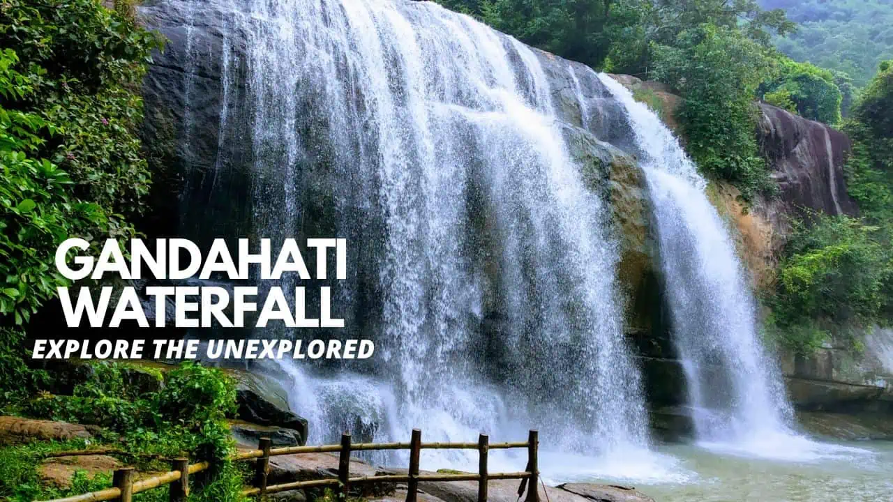
Gandahati Waterfall is one of Southern Odisha’s most scenic perennial cascades, located in the Rayagada administrative block of Gajapati district. Cascading over massive granite ledges fed by the Mahendratanaya river basin, this secluded waterfall is enveloped by dense sal forests and historic elephant migration corridors. The natural amphitheater surrounding the pool creates a shaded microclimate that attracts picnickers, landscape photographers, and eco-tourists throughout the year.
Key Takeaways
- Gandahati Waterfall drops approximately 20 meters (65 feet) down granite rock shelves within a 1,212-hectare protected forest reserve.
- The cascade maintains perennial water flow throughout the calendar year, fed by tributaries of the sacred Mahendratanaya river.
- Visitor hours run daily from 7:00 AM to 5:30 PM, with admission completely free and small vehicle parking charges at the forest gate.
- Gandahati sits 27 kilometers north of Paralakhemundi town and roughly 100 kilometers southwest of Berhampur railway station.
Gandahati Waterfall: Fast Facts and 2026 Visitor Summary
Gandahati Waterfall is managed by the local forest department and tourism authorities, offering railed stone staircases and covered pavilions for visitor safety. The table below details key geographic metrics, travel hours, and amenities cross-referenced with the Odisha Tourism official travel directory.
| Metric | Specification | Traveler Guidelines |
|---|---|---|
| Location | Rayagada Block, Gajapati District, Odisha | Sits 27 km from Paralakhemundi and 100 km from Berhampur |
| Drop Elevation | Approximately 20 meters (65 feet) | Perennial river cascade over multi-tiered granite boulders |
| Forest Reserve | 1,212.40 hectares of protected forest | Mixed deciduous woodland rich in sal, piasal, and medicinal trees |
| Visiting Hours | 7:00 AM to 5:30 PM daily | Daylight access only; gates close before sunset for wildlife safety |
| Entry Fee | Free admission for all tourists | Nominal vehicle parking fees: ₹20 (bikes) and ₹50 (four-wheelers) |
| Best Travel Season | October through March | Post-monsoon months offer full water volume and pleasant temperatures |
[!TIP] Arrive before 10:00 AM during winter weekends. Early hours provide clear morning light for photography, quiet viewing decks, and ample picnic space before regional day-trippers arrive.
Travelers comparing cascading river courses across Southern Odisha can consult our detailed directory of waterfalls across Odisha to coordinate multi-waterfall routes.
Geographic Setting and Mahendratanaya River System
Gandahati Waterfall sits at an elevation of approximately 609 feet (185 meters) above sea level in the Eastern Ghats foothills. The surrounding valley features deep laterite soil and ancient metamorphic granite boulders shaped by centuries of seasonal river flow.
The cascade is fed by perennial mountain rivulets originating from the upper catchments of the Mahendratanaya river. This sacred river flows eastward from the slopes of the Mahendragiri hill summit before irrigating agricultural valleys across Gajapati and emptying into the Bay of Bengal.
Unlike seasonal cataracts across northern plateaus that run dry by March, Gandahati maintains a consistent volume of water year-round. This dependable discharge makes the site essential for both regional irrigation canals and local wildlife populations that drink along the riverbanks.
Historical Legacy and Paralakhemundi Royal Connection
The forest tract surrounding Gandahati historically belonged to the Paralakhemundi royal estate under the Suryavamsi Gajapati rulers. Regional governance operated through the traditional Mutha system, where tribal headmen administered forested territories while preserving communal forest rights.
Maharaja Sri Krushna Chandra Gajapati Narayan Dev, a key founding father of modern Odisha in 1936, took great interest in preserving these southern woodlands. The royal family established summer retreats in the highlands and enacted early wildlife protections around the falls, as recorded in the Paralakhemundi royal estate historical records.
The name Gandahati derives from regional lore combining local words for river bends and wild elephants. Local folklore describes how large herds of Asian elephants gathered at this wide rock pool to bathe during hot summer months.
Cultural travelers visiting the area can combine the waterfall with historic royal landmarks in our comprehensive guide to places to visit across Gajapati district.
Forest Biodiversity: Sal Canopies, Indigenous Flora, and Avian Wildlife
The 1,212-hectare forest reserve encompassing Gandahati features a classic mixed deciduous forest ecosystem typical of the Eastern Ghats moist deciduous belt. The upper canopy is dominated by dense Shorea robusta (sal) trees, accompanied by Piasal (Indian kino), Arjun, and Mahua trees.
Under the forest canopy grow valuable medicinal plants, including Amla, Harida, and Bahada, which together constitute the classical Ayurvedic formulation known as Triphala. Forest conservation programs and habitat protections are coordinated through the Eco Tour Odisha forest sanctuary portal.
The forested gorge supports diverse birdlife, making Gandahati a rewarding destination for birdwatchers. Frequent sightings include the Malabar whistling thrush, Asian paradise flycatcher, golden oriole, and crested serpent eagle.
Along the river shallows above and below the main falls, quiet observers occasionally spot Asian small-clawed otters foraging among the boulders. Forest signboards urge visitors to maintain silence to avoid disturbing native wildlife.
Best Season to Visit Gandahati Waterfall
The ideal window to explore Gandahati Waterfall spans from October through March, when southern Odisha experiences dry, pleasant winter weather with daytime temperatures averaging 20°C to 28°C.
Immediately following the annual southwest monsoon in October and November, the Mahendratanaya river swells to peak discharge. The waterfall roars across its entire rock amphitheater, generating thick clouds of fine mist that drift over the lower viewing bridges.
During mid-winter (December to February), the water runs crystal-clear, and roadside mustard fields throughout Gajapati bloom in vivid yellow. Coastal travelers often pair winter trips here with boat safaris across Chilika Lake eco-destinations situated further north along National Highway 16.
Summer months between April and June bring daytime temperatures exceeding 38°C. While the waterfall still flows, visits during this period are best planned in the early morning before midday heat builds.
Nearby Attractions in Gajapati District
A day excursion to Gandahati can easily be linked with several top-tier heritage and natural attractions within Gajapati district.
Located roughly 70 kilometers north through scenic hill roads, the Chandragiri Tibetan settlement hosts the grand Padmasambhava Mahavihara. Travelers can read our Jiranga Buddhist Monastery guide to plan visits around monastic prayer schedules and traditional carpet weaving workshops.
Closer to Gandahati, Paralakhemundi town (27 kilometers south) features the grand Maharaja Palace with British and Kalinga architectural motifs, along with traditional horn-craft artisan studios in the old bazaars.
For hot springs relaxation, Taptapani sits approximately 75 kilometers away along the road toward Berhampur, featuring natural sulfur spring bathhouses and OTDC Panthanivas accommodations.
How to Reach Gandahati Waterfall: Berhampur, Rayagada, and Palasa Routes
Gandahati Waterfall is located in the Rayagada block of Gajapati district and is well-served by regional paved highways.
The distance from Rayagada district headquarters to Paralakhemundi in Gajapati is approximately 140 kilometers, requiring about three and a half hours via State Highway 4. From central Paralakhemundi, the waterfall sits just 27 kilometers north along the Paralakhemundi-Mohana road, reached in 45 minutes by car or hired auto-rickshaw.
From Berhampur railway station, travelers cover roughly 100 kilometers traveling southwest via Digapahandi and Paralakhemundi. The scenic drive takes approximately three hours through verdant paddy fields and forested ghat turns.
Air travelers landing at Bhubaneswar can cut surface transit times by utilizing seasonal flight connectivity to Rangeilunda airstrip near Berhampur. Detailed district transit roads and block subdivisions are documented in the Gajapati district administrative records.
Frequently Asked Questions About Gandahati Waterfall
What are the entry fees and opening hours at Gandahati Waterfall?
Entry to Gandahati Waterfall is free for all visitors, with gates open daily from 7:00 AM to 5:30 PM. Parking fees of ₹20 for two-wheelers and ₹50 for four-wheelers are collected at the forest entrance.
Is Gandahati Waterfall safe for swimming and family picnics?
Visitors can wade safely in the shallow rock pools near the viewing decks, but swimming directly beneath the heavy cascade drop is strictly barred due to slippery submerged rocks and deep undertows. Shaded picnic gazebos are located near the upper banks.
How far is Gandahati Waterfall from Paralakhemundi town?
Gandahati Waterfall sits approximately 27 kilometers north of Paralakhemundi town. The drive takes about 45 minutes along well-paved rural highways passing through agricultural villages.
Is Gandahati a perennial waterfall?
Gandahati is a true perennial waterfall fed by tributaries of the Mahendratanaya river, ensuring steady water flow through both peak winter months and hot summer dry seasons.
What is the road distance between Rayagada and Gajapati district?
The road distance from Rayagada town to Paralakhemundi, the administrative headquarters of Gajapati district, is approximately 140 kilometers via State Highway 4. The journey typically takes about 3.5 to 4 hours by road.